
This item below is out of stock, but another example (left) is available. To view the available item, click "Details."
Details
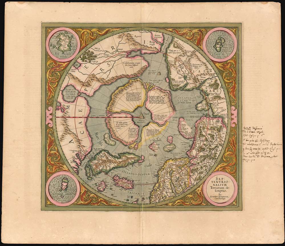
1595 First Edition Mercator Map of the Arctic (1st Map of the North Pole)
1595 (undated) $30,000.00
1606 Mercator Hondius Map of the Arctic (First Map of the North Pole)
NorthPole3-mercator-1606$2,250.00

Title
Septentrionalium Terrarum descriptio.
1613 (undated) 15 x 16 in (38.1 x 40.64 cm) 1 : 34214400
1613 (undated) 15 x 16 in (38.1 x 40.64 cm) 1 : 34214400
Description
This is the second state of Gerard Mercator's 1606 map of the North Pole or Arctic, one of the great cartographer's most interesting and important maps. Mercator's Arctic projection has its roots in a magnificent 1569 wall map of the world in which Mercator first introduces his revolutionary projection. As regards the Arctic, the difficulty with the Mercator Projection is that to accurately depict the Polar Regions, a map would have to be infinitely tall. Mercator compensated for this by including a polar projection, very similar to the map shown here, in the lower-left hand corner of his great map. This may rightly be considered to be the world's first specific map of the North Pole. Mercator later reissued this map in an expanded format for his 1595 atlas. Following a number of important expeditions to the Arctic in subsequent 10 years, Mercator's successor Jodocus Hondius reissued the original 1595 map with a number of revolutionary and highly significant changes.
The idea of a great whirlpool far to the north can also be found in many early legends and texts which are often associated with the legendary Lofoten Maelstrom in Norway. The explorers John Davis and Martin Frobisher both mention an inflowing current that they clearly believe to be the great polar rivers and the Arctic maelstrom:
All in all this is a very important early map of the North Pole and the surrounding Arctic portions of Asia, Europe, and North America. It marks a significant step forward in the cartographic understanding of the region and, more importantly, is a ground breaking transition between mediaeval and modern cosmographical perspectives.
Taking It From The Top
Our survey of this map must naturally being with the North Pole itself which Mercator envisions as a large black rock, the Rupes Nigra, surrounded by a great whirlpool into which four powerful rivers flow. These rivers divide a massive continent-sized landmass into four distinct islands or countries. When the English polymath John Dee wrote to Mercator asking about his sources for this map, Mercator returned the following letter which survives in his own hand:In the midst of the four countries is a Whirl-pool, into which there empty these four indrawing Seas which divide the North. And the water rushes round and descends into the Earth just as if one were pouring it through a filter funnel. It is four degrees wide on every side of the Pole, that is to say eight degrees altogether. Except that right under the Pole there lies a bare Rock in the midst of the Sea. Its circumference is almost 33 French miles, and it is all of magnetic Stone (…) This is word for word everything that I copied out of this author years ago.The author that Mercator refers to is generally believed be Jacobus Cnoyen van Herzogenbusch who is himself referencing an enigmatic lost work, the Inventio Fortunata (Fortunate Discoveries). Little is known of this work, save that it was composed in the 14th century and was a well-known resource for cartographers of the 15th and 16th centuries. The author of this work is a figure of considerable mystery and arguments have been made that he is Nicholas of Lynn, Thomas Kingsbury, or Hugh of Ireland. The work tells of a Minorite monk from Oxford who traveled extensively in northern lands, including Iceland, Greenland, Norway, and possibly even Labrador. The Inventio also itself references a far older and similarly lost work, the Gestae Arthuri, which adds a new chapter to the legend of King Arthur, citing that his warriors conquered Iceland, Greenland, the Faeroes, and parts of Norway.
The Magnetic North
Regardless of the attribution of Mercator's sources, the idea of the Arctic being divided into four lands surrounding a black magnetic rock was, even in the 16th century, not new. Variants on the magnetic rock theme, the Rupes Nigra, can be found in such esteemed references such as the texts of Ptolemy, which identifies several such. The presence of such a magnetic mountain at the extreme north may have seemed a natural connection for scholars attempting to explain the wonders of the compass. Curiously, although referencing the Inventio with regard to the presence of the Rupes Nigra at the Arctic Pole, Mercator does not ascribe to it any magnetic property. This he reserves for another magnetic rock located north of the Straight of Anian, which he here identifies as the magnetic pole - possibly an attempt to account for magnetic variation?The idea of a great whirlpool far to the north can also be found in many early legends and texts which are often associated with the legendary Lofoten Maelstrom in Norway. The explorers John Davis and Martin Frobisher both mention an inflowing current that they clearly believe to be the great polar rivers and the Arctic maelstrom:
This place seemeth to have a marvellous great indrafte, and draweth in to it most of the drift ice and other things which doe flote in the sea (George Best - Martin Frobisher's Lieutenant)It is hard to know exactly what these navigators witnessed, but there can be no doubt that Arctic currents in Davis's Strait are powerful and erratic.
which inlet or gulfe this afternoone and in the night we passed over: where to our great admiration we saw the sea falling down into the gulfe with a mighty overfal and roaring, and with divers circular motions like whirle-pooles. (James Davis)
Indigenous Peoples
One of the large polar islands, located north of Norway, Mercator claims is the home to a band of female Pygmies. This too references the old English voyages described in the Inventio Fortunata. The author of the Inventio seems quite clear that no vessel could survive the Polar Rivers or the great maelstrom, so any hope to accurately describe the region can be but speculative. Nevertheless, here we have a reference that is suggestive of an actual voyage to the region. The female Pygmies may well be a reference to Lapland Eskimos who are quite small in stature. That the group was predominantly female is consistent with Eskimo hunting patterns in which the men will often leave in groups to hunt.Hondius's Updates: Old meets New
Mercator's original map from his 1569 wall map, as well as the first edition of his atlas map of the Arctic, published in 1595, shows four complete islands with a solid coastline. This edition marks a significant leap forward in Arctic cartography. Mercator completed his 1595 map just before he died in 1594. Two years later the Dutchman Barentz, in search of a northwest passage, discovered Spitsbergen and rounded the northern tip of Nova Zembla. This incredible achievement redefined the cartographic perspective of the region, for the newly discovered islands were well into the latitudes where Mercator had mapped his four Arctic countries. In 1606, Mercator's heir, Jodocus Hondius, had to redraw Mercator's 1595 map to account for the Dutch discoveries in Spitsbergen and Nova Zembla (Novaya Zemlya). Attempting to reconcile recent discoveries with a century of cosmographical convention, Hondius erased part of the 'Pygmei' island and instead added Nieulant, Willoughbbe's Land and MacFin - alternate names for the islands of Spitsbergen. What Hondius thus creates is a map that embraces two realities, both of which cannot exist simultaneously. The first is the old world four island notion embraced by Mercator and the second is a modern world newly discovered. Other maps of this region would, in the subsequent decades, follow suit until, by about 1636, all trace of Mercator's four countries, the Rupes Nigra, and the Arctic maelstrom had vanished.The Manuscript
This example bears, in the right margin in a 17th century hand, nine lines of manuscript text. An early user of this map added this in order to expand on the map's treatment of the Dutch discoveries in and around Spitzbergen and Nova Zembla. The anonymous writer notes alternative names in use for the Strait of Nassau (Waygats Strait, now known as Proliv Yugorskiy Shar); he also draws attention to the discoveries around Spitzbergen and Nova Zembla. With all of these, the writer notes page numbers in the Atlas' text where the topics are treated in detail. Such marginalia is not atypical for works that saw active use, and the presence of this text on this map, and pertaining to these specific discoveries, testifies to the particular importance and interest that they held for the contemporary reader and scholar.Mythical Geography
The intriguing elements of Mercator and Hondius' map do not end with the North Pole. The mythical island of Frisland, which appears between Greenland and Iceland, is one such example. Here both the configuration of Greenland and the existence of Frisland are drawn from the Zeno Map, composed by the Venetian explorers Nicolo and Antonio Zeno. The brothers Zeno explored the coasts of Greenland in the 14th century. Some have suggested that they continued west of Greenland to land on Newfoundland, thus advocating a Venetian discovery of America. This idea has largely been discredited. However, it seems certain that they did land on the western shores of Greenland and upon their return landed in Iceland which they subsequently mapped twice, once as Frisland and once properly as Iceland. Frisland continued to appear on maps of this region well into the 16th century.North America
Mercator's interesting mapping of North America in the left hand quadrants of this map is also of exceptional interest. There are no significant changes in Hondius' 1606 treatment of the northern parts of America over Mercators 1595 treatment; however, there are significant differences between the 1595 map and the 1569 inset map, which left the region blank. One can only assume that Mercator must have come across new information regarding the northern part of the Americas in the intervening years. One such example is the 'Lago de Conibaz', a large lake, with a central island that has an outlet into a great Arctic Bay to the northeast of the Straight of Anian. Conibas appeared on a number of earlier maps including its first appearance on the Thevet Map of 1575. Thevet is known to have met with Cartier and may have derived the lake from these conversations. Some suggest that the term refers to 'Cornibotz', an alternate name for Wampum shells. In any case, this lake has been associated by some scholars with Great Salt Lake, Lake Ontario, the Great Lakes in general, and some of the other large Canadian lakes. Whatever it may be - and there is a great deal of mystery here - it does suggest that European cartographers had some sense of the great inland lakes of North America long before their official discovery.California
Mercator also, curiously, places California north of the Strait of Anian. The source of this decision is unclear. In earlier maps Mercator names this region 'Bergi Regio'. In most other maps of the period California is properly located around modern day Baja California - where it was originally identified. Thus, Mercator’s positioning of California is exceptionally curious. Mercator did everything for a reason and consequently we can speculate. California at this time was not 'California' as we understand it today. The name 'California' comes from a c. 1475 Spanish novel, Las Sergas de Esplandian (The Adventures of Esplandian) by Garci Rodríguez de Montalvo. Montalvo describes an island 'East of the Indies' inhabited by Amazons. It was the conquistador Hernan Cortez who first to attached the name California to a physical location - modern day Baja. This must have happened around 1540. Cortez at the time was searching for the Strait of Anian, the imaginary equivalent to the Bering Strait. The first mention of Anian appears in Polo's narratives, which describe it much as Montalvo descries California, as 'a place to the east of India'. This India is not modern India, but rather a term that refers to farthest Asia - China, Japan, Korea, etc. In the 16th century the line between nonfiction and fiction was not so clear as today. Cortez and the other conquistadores would have been aware of Montalvo's work, but would not necessarily have considered it entirely fictional. That is to say, they expected to discover California. Keep in mind, in those days the navigators did not believe that Asia was far beyond Mexico. By 'discovering' California in Baja, Cortez in fact believed he had at last stumbled upon Anian and a route to Asia. Thirty years later Mercator had probably figured out that Cortez's claims were baseless but the name Cortez applied to Baja stuck. Mercator himself identifies Baja as California in some of his charts of Mexico. So, why did he also place it in the Arctic? We think that here Mercator was looking for the 'true' California. It was obvious that the California of Cortez was a fiction, but that did not mean that Montalvo's idea of California was wrong, only that it has been misplaced. By attaching California to the Strait of Anian - also located to the east of Asia - Mercator was most likely working out the true placement of Montalvo's California.Revelations in Central Asia
Opposite the American side of the Strait of Anian, is the Asian land of Gog, which appears bound in a tight ring of mountains. Gog and Magog, Biblical nations from the Book of Revelations, were associated by many Europeans with the Tartars. It was believed that Alexander the Great walled off the Kingdom of Gog and Magog behind a mountain range. Many early maps, following up on this legend as well as references from the journals of Marco Polo, place either Gog or Magog in the northeastern extreme of Asia behind an impenetrable mountain range.All in all this is a very important early map of the North Pole and the surrounding Arctic portions of Asia, Europe, and North America. It marks a significant step forward in the cartographic understanding of the region and, more importantly, is a ground breaking transition between mediaeval and modern cosmographical perspectives.
Publication History and Census
This updated state of Mercator's map was introduced in the 1606 edition of the Mercator and Hondius Atlas and was included in editions of the work until 1634. This example conforms typographically to the 1613 Latin edition of the work. Although the map does appear on the market, bright examples with old color of this quality have become increasingly difficult to find.CartographerS
Gerard Mercator (March 5, 1512 - December 2, 1594) is a seminal figure in the history of cartography. Mercator was born near Antwerp as Gerard de Cremere in Rupelmonde. He studied Latin, mathematics, and religion in Rupelmonde before his Uncle, Gisbert, a priest, arranged for him to be sent to Hertogenbosch to study under the Brothers of the Common Life. There he was taught by the celebrated Dutch humanist Georgius Macropedius (Joris van Lanckvelt; April 1487 - July 1558). It was there that he changed him name, adapting the Latin term for 'Merchant', that is 'Mercator'. He went on to study at the University of Louvain. After some time, he left Louvain to travel extensively, but returned in 1534 to study mathematics under Gemma Frisius (1508 - 1555). He produced his first world map in 1538 - notable as being the first to represent North America stretching from the Arctic to the southern polar regions. This impressive work earned him the patronage of the Emperor Charles V, for whom along with Van der Heyden and Gemma Frisius, he constructed a terrestrial globe. He then produced an important 1541 globe - the first to offer rhumb lines. Despite growing fame and imperial patronage, Mercator was accused of heresy and in 1552. His accusations were partially due to his Protestant faith, and partly due to his travels, which aroused suspicion. After being released from prison with the support of the University of Louvain, he resumed his cartographic work. It was during this period that he became a close fried to English polymath John Dee (1527 - 1609), who arrived in Louvain in 1548, and with whom Mercator maintained a lifelong correspondence. In 1552, Mercator set himself up as a cartographer in Duisburg and began work on his revised edition of Ptolemy's Geographia. He also taught mathematics in Duisburg from 1559 to 1562. In 1564, he became the Court Cosmographer to Duke Wilhelm of Cleve. During this period, he began to perfect the novel projection for which he is best remembered. The 'Mercator Projection' was first used in 1569 for a massive world map on 18 sheets. On May 5, 1590 Mercator had a stroke which left him paralyzed on his left side. He slowly recovered but suffered frustration at his inability to continue making maps. By 1592, he recovered enough that he was able to work again but by that time he was losing his vision. He had a second stroke near the end of 1593, after which he briefly lost speech. He recovered some power of speech before a third stroke marked his end. Following Mercator's death his descendants, particularly his youngest son Rumold (1541 - December 31, 1599) completed many of his maps and in 1595, published his Atlas. Nonetheless, lacking their father's drive and genius, the firm but languished under heavy competition from Abraham Ortelius. It was not until Mercator's plates were purchased and republished (Mercator / Hondius) by Henricus Hondius II (1597 - 1651) and Jan Jansson (1588 - 1664) that his position as the preeminent cartographer of the age was re-established. More by this mapmaker...
Jodocus Hondius (October, 14 1563 - February 12, 1612) was an important Dutch cartographer active in the late 16th and early 17th centuries. His common name, Jodocus Hondius is actually a Latinized version of his Dutch name, Joost de Hondt. He is also sometimes referred to as Jodocus Hondius the Elder to distinguish him from his sons. Hondius was a Flemish artist, engraver, and cartographer. He is best known for his early maps of the New World and Europe, for re-establishing the reputation of the work of Gerard Mercator, and for his portraits of Francis Drake. Hondius was born and raised in Ghent. In his early years he established himself as an engraver, instrument maker and globe maker. In 1584 he moved to London to escape religious difficulties in Flanders. During his stay in England, Hondius was instrumental in publicizing the work of Francis Drake, who had made a circumnavigation of the world in the late 1570s. In particular, in 1589 Hondius produced a now famous map of the cove of New Albion, where Drake briefly established a settlement on the west coast of North America. Hondius' map was based on journal and eyewitness accounts of the trip and has long fueled speculation about the precise location of Drake's landing, which has not yet been firmly established by historians. Hondius is also thought to be the artist of several well-known portraits of Drake that are now in the National Portrait Gallery in London. In 1593, Hondius returned to Amsterdam, where he remained until the end of his life. In 1604, he purchased the plates of Gerard Mercator's Atlas from Mercator's grandson. Mercator's work had languished in comparison to the rival atlas, Theatrum Orbis Terrarum by Ortelius. Hondius republished Mercator's work with 36 additional maps, including several which he himself produced. Despite the addition of his own contributions, Hondius recognizing the prestige of Mercator's name, gave Mercator full credit as the author of the work, listing himself as the publisher. Hondius' new edition of Mercator revived the great cartographer's reputation and was a great success, selling out after a year. Hondius later published a second edition, as well as a pocket version called the Atlas Minor. The maps have since become known as the "Mercator/Hondius series". Between 1605 and 1610 Hondius was employed by John Speed to engrave the plates for Speed's The Theatre of the Empire of Great Britaine. Following Hondius' death in 1612, his publishing work in Amsterdam was continued by his widow and two sons, Jodocus II and Henricus. Later his family formed a partnership with Jan Jansson, whose name appears on the Atlasas co-publisher after 1633. Eventually, starting with the first 1606 edition in Latin, about 50 editions of the Atlas were released in the main European languages. In the Islamic world, the atlas was partially translated by the Turkish scholar Katip Çelebi. The series is sometimes called the 'Mercator/Hondius/Jansson' series because of Jansson's later contributions. Hondius' is also credited with a number of important cartographic innovations including the introduction of decorative map borders and contributions to the evolution of 17th century Dutch wall maps. The work of Hondius was essential to the establishment Amsterdam as the center of cartography in Europe in the 17th century. Learn More...
Source
Mercator, G. and Hondius, J, Atlas, 1606.
Mercator's Atlas is one of the most important works in the history of cartography. Although in fact Ortelius was the first to publish a proper atlas, the Teatrum Orbis Terrarum, Mercator's work the first book to employ the term Atlas for a collection of maps. The term is derived both from the mythical titan, Atlas, who was forced to bear the world upon his shoulders, and the Libyan king, philosopher, and astronomer of the same name that, so the legend goes, constructed the first globe. Mercator dedicated the final 25 years of his life to compile the Atlas. He published two parts during his lifetime in 1585 and 1589, but the final part published posthumously by his son Rumold Mercator, in 1595. The map plates for the Atlas were later acquired by Jodocus Hondius who published the most complete and well known edition in 1606. It was Jodocus who popularized the Atlas and who did the most to elevate Gerard Mercator's name.
Condition
Very good condition. Very lightly toned for this kind. Two marginal mends well away from printed image.
References
OCLC: 898431950. Taylor, E.G.R. (1956). 'A Letter Dated 1577 from Mercator to John Dee', Imago Mundi 13: 56–68. Van der Krogt, P. C. J., Koeman's Atlantes Neerlandici, 0020:1A. Burden, P., The Mapping of North America: A List of Printed Maps, 1511-1670, 88. Verner, Coolie and Stuart-Stubbs, B., The North Part of America, p. 142-187. National Library of Australia, 1628 MAP RM 150. Ginsberg, William B., Printed Maps of Scandinavia and the Arctic, 1482-1601, 33.3. Kershaw, K., Early Printed Maps of Canada, 23C. Costa, B. F., 'Arctic Exploration', Journal of the American Geographical Society of New York, Vol 12, p. 159-192. Pool, J., 'Spitsbergen: Early Exploration and Mapping', IMCOS Journal, vol 121, 35-42.