1688 Coronelli / Nolin Map of New Mexico - Peñalosa Geography
NouveauMexique-coronellinolin-1688$14,500.00
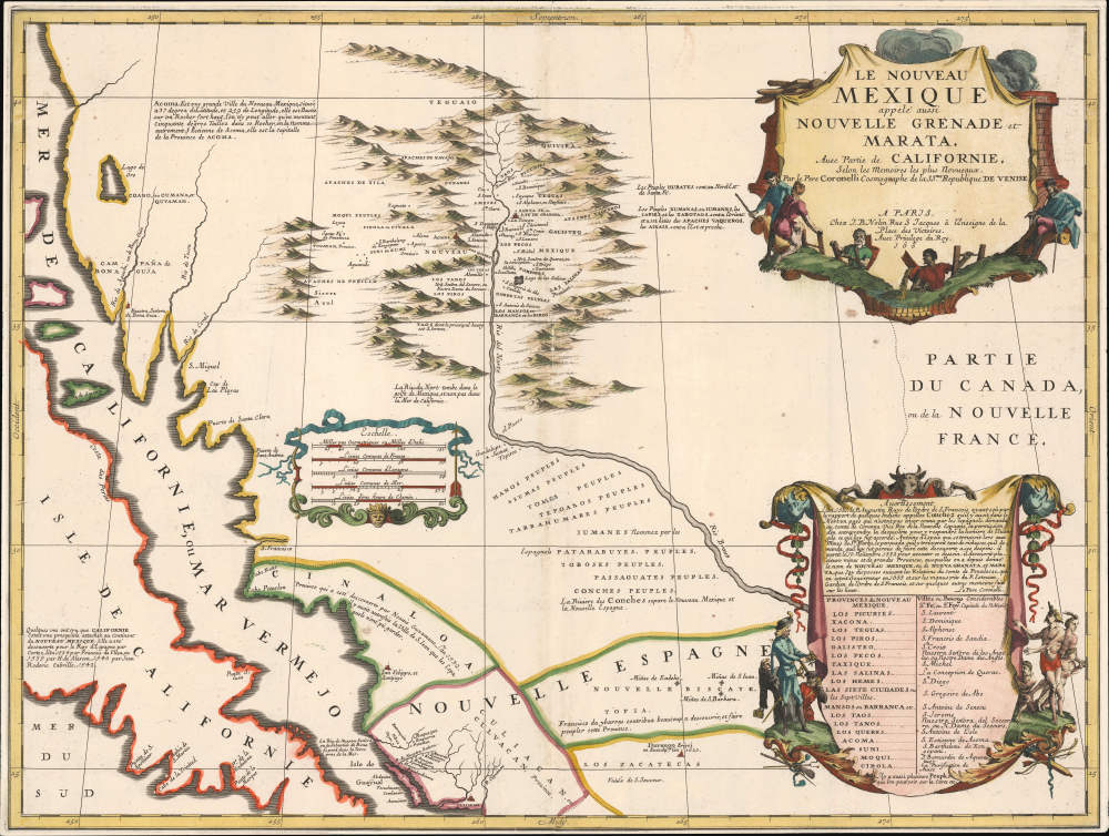

Title
Le Nouveau Mexique appelé aussi Nouvelle Grenade et Marata Avec Partie de Californie, Selon les Memoires les plus Nouveaux.
1688 (dated) 18 x 24 in (45.72 x 60.96 cm) 1 : 4500000
1688 (dated) 18 x 24 in (45.72 x 60.96 cm) 1 : 4500000
Description
A seminally important map, this is the 1687-88 Coronelli-Nolin separately-published map of the North American Southwest, in its first edition. This map is a cornerstone for any collection dedicated to the southwest: it is the first published map to introduce the cartography of Don Diego Peñalosa with regard to the Rio Grande valley as far north as Santa Fe. Peñalosa's cartography not only has a swashbucklingly enigmatic history, but it is also foundational for most subsequent maps of the region for the next century. This is also one of the earliest maps, following the 1660 Nicolosi map, to correctly map the Rio Grande emptying into the Gulf of Mexico as opposed to the Sea of California.
This last, 'Acoma' is significant and features a descriptive annotation of interest,
A Closer Look
Coverage centers on the western and northern parts of the Rio Grande, here identified as the Rio Bravo in the south, and the Rio del Norte in the north. It extends west to include the Sea of California and the 'Isle of California', and north to include what is today southern California, and south to include parts of Mexico. In modern terms, coverage incorporates most of New Mexico, parts of Arizona, Texas, southern California, and northwestern Mexico, including Baja Sur, Baja Norte, Sinaloa, Sonora, Chihuahua, Durango, Coahuila, Nuevo Leon, and Zacatecas. Annotations discuss the various provinces, noting early explorations dating to Guzamano (1532), Cortez (1534), Alarcon (1540), and Cabrillo (1542).Correcting the Rio Grande
The Rio Grande, here identified as the Rio del Norte and, to the south, the Rio Bravo, significantly, flows correctly from the mountains north of Santa Fe south, then southeast to the Gulf of Mexico. This is one of the earliest maps to make this correction, following the 1600 map of Giovanni Battista Nicolosi. Coronelli makes note of this significant point,La Riu: du Nort tombe dans le golfe de Mexique, et non pas dans la Mer de Californie.While not the first to make this correction of the Rio Grande, Coronelli's influence was such that he popularized the correction into cartographic canon.
Translation to English:
[The Rio del Norte flows into the Gulf of Mexico, and not into the Sea of California.]
New Cartography in New Mexico
Of perhaps greater significance is the Coronelli's mapping of the upper Rio Grande / Rio del Norte after the cartography of Diego Dionisio de Peñalosa Briceño y Berdugo (1621 - 1687). Peñalosa was the erstwhile governor of New Mexico, exiled by the Inquisition. Peñalosa fled to France (c. 1687), where he campaigned for France to conquer New Mexico and set him up as a modern-day Cortez. Peñalosa brought with him never-before-seen cartography; a manuscript map, likely in Peñalosa's own hands, survives in the Naval Library in Paris (Lowery 225), and is likely Coronelli's source. The map offers a wealth of never-before-published indigenous placenames in the Upper Rio Grande, as well as proper mappings of the known site: Taos, Santa Fe (correctly mapped for the first time), and Acoma.This last, 'Acoma' is significant and features a descriptive annotation of interest,
Acoma. Est une grande Ville du Nouveau Mexique, située à 37 degrés de Latitude, et 259 de Longitude, elle est Bastie sur un Rocher fort haut, l’on n’y peut aller qu’en montant cinquante degrés. Taillez dans ce Rocher, on la nomme autrement St Étienne de Acoma, elle est la Capitale de la Province de ACOMA.
[Acoma. It is a large city in New Mexico, located at 37 degrees latitude and 259 degrees longitude. It is built on a very high rock, and one can only reach it by ascending fifty degrees. Carved into this rock, it is also called St. Stephen of Acoma, and it is the capital of the province of ACOMA.]This may be the earliest published cartographic reference to the Acoma cliff dwellings. The description can be attributed to Pedro de Castañeda, who accompanied the Coronado Expedition (1540 - 1542) and sighted the dwellings in 1540.
Further north, in the mountains beyond Taos - and beyond European knowledge - are the supposed indigenous empires of Teguaio and Quivira. These kingdoms, presumed to be rich golden empires akin to the Inca, were central to Peñalosa's arguments that attacking and conquering New Mexico was a viable expenditure of resources.
The other argument for such lies lies to the south, in the mines of Nueva Vizcaya, discovered by Francisco de Ibarra (1539 - June 3, 1575), a Spanish-Basque explorer, founder of the city of Durango, and governor of the Spanish province of Nueva Vizcaya. These mines, particularly the Miñas de S. Barbara, were a key enticement. They were discovered in 1567 and, though initially difficult to exploit due to extreme remoteness and lack of indigenous labor, by 1600, Santa Barbara had become a wealthy silver center. Peñalosa argued that this valuable resource was lightly defended and would be easy for a foreign power, say France, to seize. Rene Robert Cavalier, Sieur de La Salle, active at the same time, no doubt had the mines of Santa Barbara in mind when leading his own expedition to found a colony along the Gulf - more on this below.La Salle, Peñalosa, Coronelli - Ambition and Treachery
This map is the first to capture one of the most compelling narratives of exploration, ambition, and treachery in the history of North American colonization. Coronelli's map draws heavily on the explorations and imagination of an elusive but noteworthy figure, Diego Dionisio de Peñalosa Briceño y Berdugo (1621 - 1687). Peñalosa was a Peruvian-born Creole descended from Spanish nobility. Through an array of misadventures, he briefly became Governor of New Spain before falling afoul of the Inquisition, resulting in his exile. He concocted a plan for self-aggrandizement and revenge against Spain, which he presented to King Louis XIV of France in 1687. The King declined. Nonetheless, while in the French court, he became close with René-Robert Cavelier de La Salle, who adopted his plan and successfully presented it to the King, arguing for a French settlement at the mouth of the Mississippi. Although Peñalosa was rejected, La Salle met with royal approval, and a colonization attempt ensued.
Peñalosa argued that a French colony could be easily established at or near the mouth of the Rio Bravo (Rio Grande). He suggested that the region was poorly defended and sparsely populated but that such a colony would have ready access to both the coveted silver mines of Santa Barbara and the supposed golden indigenous cities of 'Quivira' and Teguayo' (Teguaio). He composed a map to this effect, which likely does not survive but was presented to La Salle and the mapmaker Vincenzo Coronelli.
La Salle set sail for the New World with several ships and a large colonizing party. Conventional scholarship suggests that through shipboard infighting and leadership squabbles, La Salle 'missed' the mouth of the Mississippi, instead landing several hundred miles to the west, deep in Spanish territory, not far from the Rio Bravo (Rio Grande). It is more likely that the landing was intentional, as the location followed the Peñalosa plan. Whether the King was aware of La Salle's intent to follow Peñalosa's suggestions is unclear; he may have ordered La Salle's true objectives be kept secret to avoid alarming the Spanish, or it may have been subterfuge on the part of La Salle and Peñalosa.
Either way, La Salle's colony was established near the Rio Grande on the Peñalosa model. Back in France, Coronelli, with royal patronage, composed this map based on Peñalosa's information. Peñalosa's data includes numerous previously unrecorded place names, among them settlements, forts, roads, and other important features, and the location of the Mines of Santa Barbara, Edehé, and San Juan (Shown here at bottom). Peñalosa was the first to divide the Rio Grande into the southern Rio Bravo and the northern Rio Norte, and among the first to have it correctly flowing into the Gulf of Mexico.Lago de Oro
Another point of interest is the large inland lake, Lago de Oro, appearing at the western extreme of the map, just east of the Sea of California. This lake, along with the nearby Rio de Aguchi and Rio de Coral, appears on maps as early as 1604. We have been unable to unearth more information on this curious lake. It may be associated with the nearby river, Aguchi, which some have associated with the words 'Anpach', which the missionary Fray Francisco de Escobar, who accompanied Coronado, claims meant 'gold' in the language of the local indigenous peoples.Publication History and Census
This map was engraved in Venice and published by Vincenzo Coronelli and Jean Baptiste Nolin. Like many of the maps Coronelli produced with Nolin, credit is also given in the title to Jean Nicolas du Tralage (Sr. Tilleman), though his role in its production remains vague. There are two editions, the present first edition, with the date incomplete (168*), and an updated edition of 1742, with the date present. All examples are exceedingly rare.
CartographerS
Vincenzo Maria Coronelli (August 16, 1650 - December 9, 1718) was an important 17th-century cartographer and globe maker based in Venice. Coronelli was born the fifth child of a Venetian tailor. Unlikely to inherit his father's business, he instead apprenticed in Ravenna to a woodcut artist. Around 1663, Coronelli joined the Franciscan Order and, in 1671, entered the Venetian convent of Saint Maria Gloriosa dei Frari. Coronelli excelled in the fields of cosmography, mathematics, and geography. Although his works include the phenomenal Atlante Veneto and Corso Geografico, Coronelli is best known for his globes. In 1678, Coronelli was commissioned to make his first major globes by Ranuccio II Farnese, Duke of Parma. Each superbly engraved globe was five feet in diameter. Louis IV of France, having heard of the magnificent Parma globes, invited Coronelli to Paris, where from 1681-83 he constructed an even more impressive pair of globes measuring over 12 feet in diameter and weighing 2 tons each. The globes earned him the patronage of Louis XIV and privileged access to French cartographic information from Jesuit sources in the New World, particularly Louisiana. Coronelli returned to Venice and continued to publish globes, maps, and atlases, which were admired all over Europe for their beauty, accuracy, and detail. He had a particular fascination for the Great Lakes region, and his early maps of this area were unsurpassed in accuracy for nearly 100 years after their initial publication. He is also well known for his groundbreaking publication of the first accurate map depicting the sources of the Blue Nile. At the height of his career, Coronelli founded the world's first geographical society, the Accademia Cosmografica degli Argonauti, and was awarded the official title Cosmographer of the Republic of Venice. In 1699, in recognition of his extraordinary accomplishment and scholarship, Coronelli was also appointed Father General of the Franciscan Order. The great cartographer and globe maker died in Venice at the age of 68. His extraordinary globes can be seen today at the Bibliothèque Nationale François Mitterrand in Paris, Biblioteca Marciana in Venice, the National Library of Austria, the Globe Museum in Vienna, the Library of Stift Melk, the Special Collections Library of Texas Tech University, as well as lesser works in Trier, Prague, London, and Washington D.C. Coronelli's work is notable for its distinctive style, which is characterized by the high-quality white paper, dark intense impressions, detailed renderings of topographical features in profile, and numerous cartographic innovations. More by this mapmaker...
Jean-Baptiste Nolin (1657 - 1725) was a French cartographer and publisher active in Paris during the late 17th and early 18th centuries. Nolin was a man of exceptional business acumen and while many cartographers struggled financially, he prospered. Many attribute this to the fact that Nolin produced very little original work, relying primarily on business relationships with the legendary Italian cartography Vincenzo Coronelli, Jean-Dominique Cassini, and the French geographer Jean Nicolas du Trallage, Sieur de Tillemont (1620 – 1698). His work is known for exceptional aesthetic élan, combining Italianesque baroque and rococo ethics with most current cartographic data. It might also be said that Nolin was a bit of a con-artist in his self-promotion, often inaccurately using such titles as 'Engraver to the King' and 'Geographer to the Duke of Orleans', neither of which appointments he actually held. In 1705, he was successfully sued by Guillaume De L’Isle for copyright infringement, a case which cost him significant scientific credibility. Nonetheless, Nolin remained commercially popular and prosperous. Nolin's son, also Jean Baptiste Nolin (1686 - 1762) inherited his father’s map plates and republished many of his maps, as well as issuing his own unique maps, well into the 18th century. Both Nolins maintained offices on Rue St. Jacques, Paris. Learn More...
Jean-Nicolas de Tillemont (fl. c. 1640 - 1720), a.k.a. Jean Nicolas du Tralage, Sieur de Tillemont, was a French cartographer best known for his collaborations with the Italian cartographer Vincenzo Coronelli and French map publisher Jena Baptiste Nolin. Most of Tillemont's work involved re-engineering and updating Coronelli's maps for the French market in partnership with Nolin. Little else is known of his life. Learn More...
Source
Coronelli, V., Cartes Generales des Royaumes de l'Europe et des Particuliers de France, (Paris: Chez I. B. Nolin) 1693.
Condition
Very good. Expert fiber reinforcement to margins.
References
Library of Congress, G4300 1685.C6. Princeton,
HMC01.6798. Burden, P., The Mapping of North America, #631. Cohen, pp.43-45. Lowery, W., The Lowery Collection, #177. Wheat, C. I., Mapping of the Transmississippi West, 1540 – 1861, #66.