
This item below is out of stock, but another example (left) is available. To view the available item, click "Details."
Details
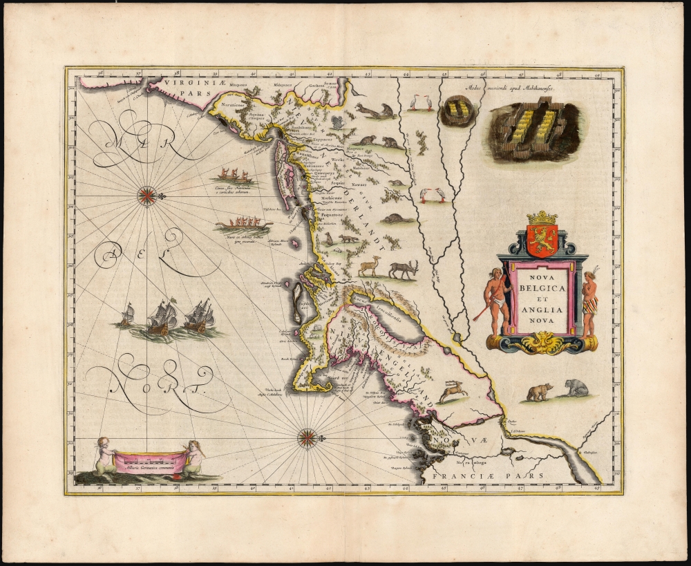
1634 Blaeu Map of New England and the New Netherlands: First Edition!
1634 (undated) $6,500.00
1640 Blaeu Map of New England and the New Netherlands
NovaBelgicaetAngliaNova-blaeu-1634$2,375.00


Title
Nova Belgica Et Anglia Nova.
1634 (undated) 15.25 x 20 in (38.735 x 50.8 cm) 1 : 3300000
1634 (undated) 15.25 x 20 in (38.735 x 50.8 cm) 1 : 3300000
Description
This is a beautiful c. 1640 example of Willem Blaeu's 1634 map of the American Northeast, the region settled by the Dutch (New Netherlands) and the English (New England). Oriented to the west, Blaeu's map covers the American coast from Virginia, past New York and Long Island to Cape Cod, New England, and Quebec. The map is the first of the region to accurately depict the fur-bearing and food animals of the region, and it does so in profusion. Between this imagery, and the fleet of trade ships heading towards the coast, the decorative elements vividly emphasize the potential for wealth offered by this region.
Adriaen Block's Map
This map is cartographically derived from data accumulated by Adriaen Block and other Dutch fur traders active in the early 17th century. Burden writes:This important map was one of the most attractive of the Americas at the time. It is noted for the fact that its primary source is the first manuscript map of Adriaen Block, 1614. Indeed, it is the first full representation of it in print. It is one of the earliest to name Nieu Amsterdam. Block, a Dutch fur trader, explored the area between Cape Cod and Manhattan, examining the bays and rivers along the way. This helped to create an accurate picture of the longitudinal scale of the coastline. His manuscript map was the first document to delineate an insular Manhattan; it also provides the earliest appearance of Manhates and Nieu Nederland.Despite the early year of the Block manuscript, it would be at least fifteen years before Blaeu began work on the printed version. The Stokes Collection in New York possesses an example of the map on thicker paper without text on the reverse which could well be a proof issue of some kind, to which has been attributed a date of 1630.
Blaeu's Updates
Blaeu's map is not a slavish copy of the Block chart. Some of these changes apparent here could be accounted for by the fact that the surviving Block map is not the original, and that the copyist omitted some place names referred to in the text of de Laet's work of 1630. Block drew on Champlain's map of 1612 for the depiction of his namesake lake, here named Lacus Irocoisiensis, referencing the Five Nations in whose domain that lake lay. The eastward displacement of this lake from its true position north of the Hudson River is testament to the extent to which the Dutch and the French were not, at this point, sharing information.Interesting Toponomy
Some nomenclature has its origins in Blaeu's second Paskaert of c.1630, and others, such as Manatthans, in de Laet. The English colony of Nieu Pleimouth is identified. This and other English names along that part of the coast are largely derived from Smith's New England, 1616. Cape Cod is here improved over the Block manuscript by being reconnected to the mainland, the narrow strait having been removed. The coastline between here and Narragansett Bay, which can be clearly recognized, is not so accurate. Adriaen Blocx Eylandt leads us to the Versche Rivier, or Connecticut River, which Block ascended as far as was possible. 't Lange Eyland is named; however, it is incorrectly too far east, being applied to what is possibly Fishers Island. De Groote bay marks Long Island Sound. The Hudson River is still not named as such, but is littered with Dutch settlements, and the failed Fort Nassau is here depicted renamed as Fort Orange. He does, however, improve on the direction of its flow. Blaeu separates the sources of the Hudson and Delaware Rivers which had been causing some confusion. Nieu Amsterdam is correctly marked as a fort at the tip of an island separated on the east side by Hellegat, or the East River. The coastline south of Sandy Hook also shows signs of improvement.A Decorative Trailblazer
Blaeu's map was the first of the region to depict, reasonably accurately, the fauna of the northeast. The whole map is adorned by deer, foxes, bears, egrets, rabbits, cranes, and turkeys. Beavers, polecats, and otters appear here for the first time on a printed map. The map also includes an engraving of a Mohawk village at the top right, loosely derived from the De Bry-White engravings. The impact of these decorative flourishes was widespread in the map trade: Jansson's map of the same region, derived from the 1630 De Laet, had shared its predecessor's Spartan aesthetic. Almost immediately on the 1634 publication of the Blaeu map, Jansson reworked his own map: copying wholesale virtually all the decorative elements of this map.Publication History and Census
This map was engraved as early as 1630, and first appeared in Blaeu's atlas in the German edition of 1634. It would prove to be a staple map of Blaeu's atlases, and it was included in every edition of the firm's output until its dissolution in 1672. It appears in only one state. Consequently, the map is well represented in institutional collections, and can be found on the market with some regularity. The present example was included in one of the German editions of Atlas Novus beginning in 1640, or Joan Blaeu's magnificent Atlas Maior. (The pagination for these editions of both works is the same for this map.) Examples of this map come on the market from time to time.CartographerS
Willem Janszoon Blaeu (1571 - October 18, 1638), also known as Guillaume Blaeu and Guiljelmus Janssonius Caesius, was a Dutch cartographer, globemaker, and astronomer active in Amsterdam during the late 16th and early 17th centuries. Blaeu was born 'Willem Janszoon' in Alkmaar, North Holland to a prosperous herring packing and trading family of Dutch Reformist faith. As a young man, he was sent to Amsterdam to apprentice in the family business, but he found the herring trade dull and instead worked for his cousin 'Hooft' as a carpenter and clerk. In 1595, he traveled to the small Swedish island of Hven to study astronomy under the Danish Enlightenment polymath Tycho Brahe. For six months he studied astronomy, cartography, instrument making, globe making, and geodesy. He returned to Alkmaar in 1596 to marry and for the birth of his first son, Johannes (Joan) Blaeu (1596 – 1673). Shortly thereafter, in 1598 or 1599, he relocated his family to Amsterdam where he founded the a firm as globe and instrument makers. Many of his earliest imprints, from roughly form 1599 - 1633, bear the imprint 'Guiljelmus Janssonius Caesius' or simply 'G: Jansonius'. In 1613, Johannes Janssonius, also a mapmaker, married Elizabeth Hondius, the daughter of Willem's primary competitor Jodocus Hondius the Elder, and moved to the same neighborhood. This led to considerable confusion and may have spurred Willam Janszoon to adopt the 'Blaeu' patronym. All maps after 1633 bear the Guiljelmus Blaeu imprint. Around this time, he also began issuing separate issue nautical charts and wall maps – which as we see from Vermeer's paintings were popular with Dutch merchants as decorative items – and invented the Dutch Printing Press. As a non-Calvinist Blaeu was a persona non grata to the ruling elite and so he partnered with Hessel Gerritsz to develop his business. In 1619, Blaeu arranged for Gerritsz to be appointed official cartographer to the VOC, an extremely lucrative position that that, in the slightly more liberal environment of the 1630s, he managed to see passed to his eldest son, Johannes. In 1633, he was also appointed official cartographer of the Dutch Republic. Blaeu's most significant work is his 1635 publication of the Theatrum orbis terrarum, sive, Atlas Novus, one of the greatest atlases of all time. He died three years later, in 1638, passing the Blaeu firm on to his two sons, Cornelius (1616 - 1648) and Johannes Blaeu (September 23, 1596 - December 21, 1673). Under his sons, the firm continued to prosper until the 1672 Great Fire of Amsterdam destroyed their offices and most of their printing plates. Willem's most enduring legacy was most likely the VOC contract, which ultimately passed to Johannes' son, Johannes II, who held the position until 1617. As a hobbyist astronomer, Blaeu discovered the star now known as P. Cygni. More by this mapmaker...
Joan (Johannes) Blaeu (September 23, 1596 - December 21, 1673) was a Dutch cartographer active in the 17th century. Joan was the son of Willem Janszoon Blaeu, founder of the Blaeu firm. Like his father Willem, Johannes was born in Alkmaar, North Holland. He studied Law, attaining a doctorate, before moving to Amsterdam to join the family mapmaking business. In 1633, Willem arranged for Johannes to take over Hessel Gerritsz's position as the official chartmaker of the Dutch East India Company, although little is known of his work for that organization, which was by contract and oath secretive. What is known is his work supplying the fabulously wealthy VOC with charts was exceedingly profitable. Where other cartographers often fell into financial ruin, the Blaeu firm thrived. It was most likely those profits that allowed the firm to publish the Theatrum Orbis Terrarum, sive, Atlas Novus, their most significant and best-known publication. When Willem Blaeu died in 1638, Johannes, along with his brother Cornelius Blaeu (1616 - 1648) took over the management of the Blaeu firm. In 1662, Joan and Cornelius produced a vastly expanded and updated work, the Atlas Maior, whose handful of editions ranged from 9 to an astonishing 12 volumes. Under the brothers' capable management, the firm continued to prosper until the 1672 Great Amsterdam Fire destroyed their offices and most of their printing plates. Johannes Blaeu, witnessing the destruction of his life's work, died in despondence the following year. He is buried in the Dutch Reformist cemetery of Westerkerk. Johannes Blaeu was survived by his son, also Johannes but commonly called Joan II, who inherited the family's VOC contract, for whom he compiled maps until 1712. Learn More...
Adriaen Block (c. 1567 – 1627) was a Dutch private trader, privateer, and ship's captain best known for exploring the coastal and river valley areas between present-day New Jersey and Massachusetts between 1611 to 1614. He is associated with possibly having named Block Island, Rhode Island, and establishing early trade with the Native Americans. The 1614 map of his last voyage provided the basis for Willem Blaeu's Nova Belgica et Anglia Nova, which would present many European readers with their first image of the mid-Atlantic region appear for the first time. The term 'New Netherland' appeared on the Block chart for the first time.
Though his childhood is obscure to us, by 1590 Block appears to have been active in the European shipping trade and by 1601, he had sailed as far as the Dutch East Indies. By 1604 he had been granted Letters of Marque from Dutch authorities to capture enemy ships, on which he seems to have made good at least once. Reports of Hudson's 1609 voyage to the Hudson Valley led Block to make three journeys to the same vicinity and its surrounds. He would be the first known European to sail through Hell Gate and explore the East River, and one of the first to explore Long Island Sound. Learn More...
Source
Blaeu, W., Atlas Maior, (Amsterdam: Blaeu) 1640-1670.
In 1662 Joan Blaeu published his masterwork, which has been described as 'the greatest and finest atlas ever published' (Verwey, 1952): his monumental, eleven-volume Atlas Maior. This contained nearly six hundred maps, more than two hundred in excess of the Blaeus' mainstay the Atlas Novus. The former work already being renowned for the quality and beauty of its maps, Blaeu not only added copious material but improved the sophistication of his work: many of the newly-added maps utilized larger-sized presses and sheets, and the artistry applied to the engravings was often far superior to that of the earlier maps in the atlas - many of which by now were 30, and some more than 50 years old. Blaeu's Atlas Maior was published from 1662 to 1672, consisting of some 594 maps compiled into upwards of 9 volumes with some editions containing as many as 12 volumes. This triumphant work's publishing life was cut violently short when, in 1672, the Blaeu's mammoth workshop was destroyed by fire; surviving stock would be sold at auction between 1674 and 1677, occasionally appearing under the imprint of later Dutch printers such as Pieter Schenk and Pieter Mortier. The maps added to the Atlas Maior, owing to their tragically short publishing life, are among the hardest-to-find of the Blaeu maps.
Condition
Very good. Expert centerfold mend at bottom just entering border with no loss, else excellent with generous margins and superb original color, possibly refreshed.
References
OCLC 46842203. Burden, P., The Mapping of North America, 241. Schwartz, S. and Ehrenberg, R., The Mapping of America,pl.58, p.103. McCorkle, B. B, New England in Early Printed Maps 1513 - 1800, 635.1.