
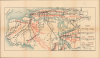
1925 French Subway Map of New York City


This item has been sold.
Légende New York Subway.
Height of the Subway Building Boom. - in French.
Choose a Collection:
- Digital Map Information
- Suitable for large format printing
- Full resolution TIFF file
- ICC color profile embedded
- Delivered instantly via download link
This Item
Enquire
Height of the Subway Building Boom. - in French.
This is an unusual 1925 French-language map of the New York City Subway System, at that time divided between the Interborough Rapid Transit Company (IRT) and the Brooklyn-Manhattan Transit Corporation (BMT). The map captures the city's system of subway and elevated lines near their peak, in the midst of a construction boom, before the combination of several factors began to severely strain the system.A Closer Look
The map is oriented towards the west, with Manhattan and the Bronx at the top and Queens and Brooklyn below. Subway lines are traced in black and elevated lines are red, with the lines of the IRT and BMT (operating as the New York Municipal Railway Corp. under the Dual Contracts, discussed below) distinguished by solid or dashed lines. Lines under construction are also depicted, with express portions distinguished from local service (omnibus), including today's 1 (Broadway-Seventh Avenue Local) and E (Eighth Avenue Express) trains. Insets cover the downtown sections of Manhattan and Brooklyn in greater detail.Height of the Subway and Elevated System
During the 1920s, New York City's mass transit system experienced a chaotic yet spectacular period of growth, driven by the historic Dual Contracts expansion in 1913, in which the IRT and Brooklyn Rapid Transit Company (BRT, predecessor to the BMT) coordinated with each other and the city to rehabilitate existing lines and expand new ones. The two companies raced to weave together networks of subway lines and wooden elevated 'els,' the latter running north and south along several major avenues in Manhattan and above important arteries in the boroughs. This transit boom transformed the city's geography, turning remote outer-borough farmlands into bustling residential hubs practically overnight. However, political friction was brewing beneath the surface. Frustrated by the private companies, populist Mayor John Hylan (in office 1918 - 1925) broke ground on the Independent Subway System (IND) in 1925. This entirely city-owned-and-operated network was explicitly designed to compete with, and eventually choke out, the private lines.The momentum of the 1920s careened into a sharp decline over the subsequent decades due to political stubbornness and shifting American lifestyle trends. City leaders rigidly enforced a mandated five-cent fare, refusing to raise it despite high post-WWI inflation. This move starved the IRT and BMT of the revenue required for basic maintenance and modernization, driving both giants into bankruptcy and forcing a unified city takeover in 1940. The rise of automobile culture, suburbanization, and the highway-centric planning of figures like 'Power Broker' Robert Moses diverted critical funding away from public trains. The iconic, noisy elevated lines were progressively dismantled as urban eyesores, leaving a financially strained, deferred-maintenance subway system to navigate a decades-long uphill battle toward recovery.
Publication History and Census
This map was prepared by an unknown cartographer in or around the year 1925 (dated by the designation of 'lignes en construction 1925'). Presumably, it was intended for French-speaking visitors to the city and may have appeared in a French-language city guide. We have been unable to locate any other cataloged examples.Condition
Very good. Light wear along original fold lines. Closed margin tears professionally repaired on verso. Slight loss at a fold intersection. Verso repair to a fold separation.