
1944 Ward / Pitner Octant Projection 'Octovue' Map of the World

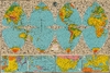

The Illustrated World Octovue Projection.
Projection for the Postwar World.
- Digital Map Information
- Suitable for large format printing
- Full resolution TIFF file
- ICC color profile embedded
- Delivered instantly via download link
Projection for the Postwar World.
This is Harold B. Ward and L. E. Pitner's visually stunning, large-format 1944 'octovue' map of the world, an illustrated folding map conceived to teach geography for the aviation age. In the interest of mathematical and geographical accuracy, it divides the globe into eight curved triangular sections rather than stretching the continents across a continuous rectangular surface. Its accompanying explanations connect this unfamiliar arrangement to a world being drawn closer together by aircraft, while pictures introduce the inhabitants, industries, wildlife, and landmarks of distant countries. This vision of global connectivity ran counter to the world's situation during the most intense phase of World War II (1939 - 1945), but presaged the world that would emerge from the conflict.A Closer Look
The world unfolds in eight sections lettered A through H, with four northern octants above four southern octants. A globe near the top illustrates the sphere's underlying division. Color-shading is used to differentiate topography and terrain. Rivers, cities, national and regional boundaries, mountain elevations, and selected ocean depths are all indicated. George O. Young's black-line illustrations fill the spaces outside and between the colored sections, depicting a wide range of subjects, including Tibetan monasteries, Japanese fishing boats, Canadian logging, American oil wells, Brazilian coffee drying, and South African gold mining. Landmarks such as Boulder Dam, the George Washington Bridge, and the Sydney Harbor Bridge also appear. Four supplementary panels along the bottom address Eastern Asia, the Pacific Islands, the United States, and Europe. These were almost certainly included so readers could follow developments in the ongoing world war, which is otherwise scarcely mentioned. (The Eastern Asia panel does include the Burma Road.)The 'Pitner Projection'
The 8-part arrangement was the central proposition of the publication. Its explanatory diagrams ask readers to imagine dividing a globe at the equator, cutting each hemisphere into four parts, and transferring the resulting spherical triangles to paper. The same sections could then be arranged either on the north-up world map on the front cover or around the poles in the hemisphere maps on the verso. The text presents Octovue as a solution to the distortion of shapes, sizes, distances, and positions. It uses diagrams of Greenland to criticize familiar Mercator maps.Contrary to the map's grandiose claim to be 'unique in the history of mapmaking' and that 'For the first time since the dawn of civilization, you see... a sphere spread out before you on a flat surface, free of distortions either in size, in shape, in distance or in position,' octant world map projections had been conceived as early as the 16th century (including, perhaps, by Leonardo da Vinci). They appeared as printed maps in the early 17th century by Nicolaas Geelkercken (1616) and Daniel Angelocrater (1628), using eight gores as Ward and Pitner do here. Such maps do not 'solve' the issue of projecting a three-dimensional sphere onto a two-dimensional surface, as Pitner suggests here, but they can be argued to be more mathematically accurate than Mercator projections, which were originally intended for navigation.
The Verso: An Illustrated Geography for a Smaller World
On the verso, two four-lobed polar hemisphere maps rearrange the octants around the North and South Poles, with alternating colors identifying time zones. An adjacent 'Geografacts' column explains time, distance, latitude, longitude, and basic facts about the Earth, while a densely printed index and gazetteer supplies locations, populations, areas, and descriptions of political divisions, cities, and islands. The introductory essay identifies educators, students, and travelers as the intended audience. More significantly, it explains why their geographical understanding needed to change: steamships and aircraft were reducing the time separating distant peoples. A diagram compares the apparent size of the world, expressed in travel time, in 1800, 1900, and 1944. Another passage argues that aviation had brought Americans as close to Tibet and India as earlier generations had been to friends in other states.Two galleries of colored pictures extend that argument. One pairs places with modes of travel, including Venice and its gondolas, the Yukon and dog sleds, Tibet and yaks, and New Mexico and a streamlined train. The other, headed 'Our New Neighbors,' presents people in regional dress and settings, with a prominent Statue of Liberty among the surrounding scenes. As with the map and extensive text, these illustrations hint at the internationalism of the Postwar period.
The Accompanying Promotional Brochure
A separate brochure demonstrates how the map's distributor, Wilcox and Follett, marketed Octovue to American schools, libraries, and households. Its illustrated cover surrounds a segmented globe with readers of different ages beneath an airplane and the promise to show the world as it really is. Inside, comparisons with Mercator, hemisphere, and ellipsoidal maps assign Octovue a markedly superior publisher-devised utility rating. The other side advertises a related classroom wall map and a twenty-page book version. An order form offers several roller-mounted and muslin-backed formats.Publication History and Census
This map was prepared by Pitner, with assistance from Ward, and printed by the E. F. Schmidt Company in Milwaukee, Wisconsin, in 1944 for distribution by Wilcox and Follett. It follows a 1943 edition, titled 'Air age octovue map of the world,' which is seemingly more common. This edition is cataloged only in the holdings of the University of California, Berkeley; Université Laval; and the University of Southern Maine's Osher Map Library.Cartographers
Harold B. Ward (fl. 1918 - 1944) was a United States-based geographer and educational map editor associated with the University of Chicago and with world-map publishing in Milwaukee during the first half of the 20th century. In 1918, he was listed as an assistant in the University of Chicago's Department of Geography and as undergoing training for the Engineer's Corps in Washington, D.C. His subsequent academic work included the University of Chicago doctoral dissertation Hamilton, Ontario, as a Manufacturing Center, an investigation of urban industrial geography. Ward's cartographic activities included editing 'The Illustrated World Octovue Projection,' designed and published by L. E. Pitner in Milwaukee in 1944. This illustrated world map presented the Earth in eight sections, accompanied by regional insets and numerous vignettes of landscapes, wildlife, and human activities; its editorial credit identified Ward with the qualifications Ph.D. and F.R.G.S. Ward also appears to have taught at Northwestern University and the George Peabody College of Teachers in Nashville. Further Details...
Lloyd E. Pitner (fl. 1943 - 1944) was an American map designer and publisher active in Milwaukee, Wisconsin, during the mid-20th century, known for his Octovue world maps. Working with editor Harold B. Ward, he published the Air Age Octovue Map of the World in 1943 and The Illustrated World Octovue Projection in 1944. The latter identifies his publishing address as 229 West Mineral Street, Milwaukee. Pitner's projection divided the globe into eight spherical triangular sections, four north and four south of the equator, arranged on a flat sheet. The illustrated version supplemented this geographical framework with numerous vignettes depicting wildlife, landmarks, transportation, and regional cultures, together with inset maps and explanatory material. Although its promotional text claimed freedom from distortion of shape, size, and distance, the Octovue system is more cautiously described in the cartographic literature as resembling oblique Lambert azimuthal equal-area projections centered symmetrically on individual octants. Further Details...
Emil F. Schmidt (born December 1, 1894 - ?) was an American lithographic printer and founder of the E. F. Schmidt Company, a Milwaukee advertising and lithographic printing business established in 1923. According to city directories, Schmidt had some experience in the field before founding his own firm, though his employer is not recorded. The E. F. Schmidt Co. invested early in sheet-fed offset lithography, being one of several Milwaukee firms using this method that carved out specialized niches for themselves. For Schmidt, this was as a specialist producer of corporate advertising calendars, expanding its market throughout the Midwest during the 1950s and 1960s and subsequently reaching customers in New York. Its clients included General Electric and Pan American Airways, which ordered imprinted calendars for distribution to employees and customers. Corporate annual reports complemented this seasonal calendar business. During the 1970s, the company invested in specialized binding machinery and shifted from sheet-fed printing to web-offset production, using continuous rolls of paper, at a new plant in Menomonee Falls, Wisconsin. It is unclear when Emil F. Schmidt died, but the business remained under Schmidt family ownership, with Harold Schmidt (perhaps a brother) serving as president until his death in 1978 and another brother serving as chairman. Thereafter, management increasingly pursued large-run retail catalogs, securing business from Neiman-Marcus, the Horchow Collection, and other department stores. In 1981, Arandell acquired the company, and the combined enterprise became Arandell-Schmidt Corporation (originally founded as R and L Service Inc.), continuing the predecessor firm's expansion into color catalog printing. The Arandell Corporation continues to operate today as one of the leading producers of catalogs for upscale retailers in the United States. Further Details...
Condition
Excellent.
References
OCLC 21829212. Snyder, J. and Steward, H., eds., Bibliography of Map Projections, (second edition) 1997, #2124 and #2812.