
Schmidt, Emil F.
Projection for the Postwar World.
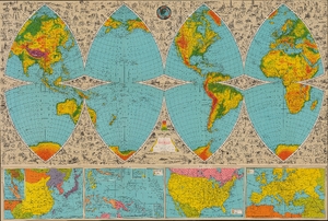
The Illustrated World Octovue Projection.
$1,500.00
Acquire
- Digital Map Information
- Suitable for large format printing
- Full resolution TIFF file
- ICC color profile embedded
- Delivered instantly via download link
This is Harold B. Ward and L. E. Pitner's visually stunning, large-format 1944 'octovue' map of the world, an illustrated folding map conceived to teach geography for the aviation age. In the interest of mathematical and geographical accuracy, it divides the globe into eight curved triangular sections rather than stretching the continents across a continuous rectangular surface. Its accompanying explanations connect this unfamiliar arrangement to a world being drawn closer together by aircraft, while pictures introduce the inhabitants, industries, wildlife, and landmarks of distant countries. This vision of global connectivity ran counter to the world's situation during the most intense phase of World War II (1939 - 1945), but presaged the world that would emerge from the conflict. (more details)