This item has been sold, but you can get on the Waitlist to be notified if another example becomes available, or purchase a digital scan.
1848 / 1850 Fremont / Preuss Map of Upper California and the Great Basin
OregonUpperCalifornia-preuss-1848$425.00

Title
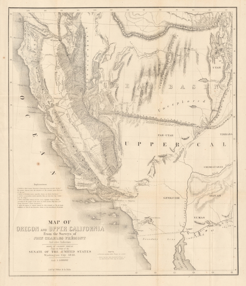
Map of Oregon and Upper California From the Surveys of John Charles Frémont And other Authorities.
1848 (dated) 20.75 x 18 in (52.705 x 45.72 cm) 1 : 3000000
1848 (dated) 20.75 x 18 in (52.705 x 45.72 cm) 1 : 3000000
Description
This is the c. 1850 second issue of John C. Frémont and Charles Preuss' seminal 1848 map of the American West, often considered the first accurate mapping of the vast region between the Rocky Mountains and the Pacific Ocean. Although smaller than the 1848 map on which it is based (UpperCaliforniaOregon-fremont-1848), being later, this issue was also able to include some information not on the original.
Maintaining the same scale as the larger first issue, this map instead covers a narrower swath of the continent, as far north as the 42nd parallel and as far east as the 112th parallel, whereas the first issue extends northwards to the 49th parallel north (the modern U.S.-Canada border) and further eastwards into New Mexico. However, the present map traces more of Frémont's travels in California's Central Valley and passes through the Coast Ranges. This second issue was generally included with copies of President Polk's report to the House of Representatives on California and New Mexico (House Ex. Doc. 17, 31st Congress, 1st Session), as opposed to the larger, earlier 1848 issue of Frémont's report to Congress.
A Closer Look
Coverage includes the Spanish province and then Mexican territory of Alta California with portions of the surrounding territories, including the modern states of California, Nevada, Arizona, and Utah. The map includes many important details that are of considerable historical significance, as well as curiosities such as ephemeral place names. Many of these occur in and around the gold region of California, which may have made its first appearance in print on the 1848 issue of Frémont's map. Sacramento remains 'Nueva Helvetia' here, the name given to it by John Sutter, on whose property gold was first discovered in 1848. Lake Tahoe makes a scarce appearance as 'Lake Bonpland' while other places maintain a form of their Spanish ('Rio d. l. Plumas,' 'R. d. l. Americanos,' Monte Rey) or Indian names (Mt. Tsashtl). Two settlements are labeled 'S. Jose,' one at the location of the modern city of that name and one, ironically, at the location of the later town of Frémont, named for the map's creator. This map also includes the first reference to the Mormon settlements along the Great Salt Lake on a printed map.Maintaining the same scale as the larger first issue, this map instead covers a narrower swath of the continent, as far north as the 42nd parallel and as far east as the 112th parallel, whereas the first issue extends northwards to the 49th parallel north (the modern U.S.-Canada border) and further eastwards into New Mexico. However, the present map traces more of Frémont's travels in California's Central Valley and passes through the Coast Ranges. This second issue was generally included with copies of President Polk's report to the House of Representatives on California and New Mexico (House Ex. Doc. 17, 31st Congress, 1st Session), as opposed to the larger, earlier 1848 issue of Frémont's report to Congress.
Historical Context
This map emerged in the wake of the Mexican-American War (1846 - 1848) and the signing of the Treaty of Guadalupe Hidalgo, which ceded vast new territories to the United States, including the present-day states of California, Nevada, Utah, New Mexico, most of Arizona and Colorado, and parts of Oklahoma, Kansas, and Wyoming. As the area was poorly understood, Frémont's reports and Preuss' maps were the best available geographic references to the region. According to Wheat,in the history of the American West, the year 1848 is signalized by three events above all others, the discovery of gold at Sutter's Mill… the formal close of the Mexican War… which brought the cession of California and New Mexico… and the creation of the Territory of Oregon… All three events figure in the characteristic maps produced during the year, and particularly the cartographic monument of 1848, the magnificent 'Map of Oregon and Upper California. (Wheat, C. I., Mapping of the Transmississippi West, 1540 - 1861, 49).
Publication History and Census
This map was originally published in 1847 to accompany Frémont's 1848 Geographical Memoir upon Upper California (30th Congress, 1st session, Senate miscellaneous document 148; and 2nd session, House miscellaneous document 5). It was drawn by Charles Preuss and then engraved and printed by E. Weber of Baltimore (soon after renamed A. Hoen). This second issue appeared in the January 21, 1850 'Report of President Taylor to the House of Representatives providing information on the subject of California and New Mexico' (31st Congress, 1st Session. Ex. Doc. No. 17). Due to their identical title and publication information, and highly similar appearance, this issue is often cataloged as the 1848 issue, making a census difficult to establish. Both issues have become scarcer and more desirable in recent years.CartographerS
John Charles Frémont (January 21, 1813 - July 13, 1890) was an American military officer, politician, and explorer. Fremont was born in Savannah, Georgia. A man of adventure, Frémont led several expeditions into the American West in the 1840s, earning the nickname 'The Pathfinder.' His explorations, documented in reports and maps, significantly contributed to the understanding of the western United States and were instrumental in guiding settlers to the region. Frémont's military career was marked by his role in the Bear Flag Revolt (June 1846), leading to the annexation of California as part of the United States. In politics, he was a prominent figure in the early Republican Party and was its first presidential candidate in 1856, though he was unsuccessful in his bid. His later life was marred by controversy and financial troubles, but his early contributions to the exploration and expansion of the American West cemented his place in U.S. history. He died in 1890 in New York City. More by this mapmaker...
Charles Preuss (1803 - September 2, 1854), or as he was born George Karl Ludwig Preuss, was a German-born lithographer and cartographer who produced several important maps of the American West in the middle part of the 19th Century. Preuss was born in Hohscheid, Germany, where grew up and studied the science of Geodesy. There he also studied lithography with its inventor, Aloys Snefleder. After mastering the art, he worked under the Prussian Government as a mapmaker and surveyor. Preuss immigrated to the United States with his wife and children in 1834. In the United States, he worked at a few minor drafting positions before taking work under Ferdinand Hassler and the U.S. Coast Survey. Hassler introduced Preuss to Captain John Charles Fremont, who was then planning his landmark surveying expedition to the American West. Impressed with Preuss' work, Fremont hired him as the expedition's cartographer. Preuss seems to have been singularly unimpressed with Fremont and the American West, complaining bitterly in his journals about both. He considered Fremont "childish" and the scenery "dull" and "lackluster." Nonetheless, he was convinced to participate in one expedition after another, and the maps he produced, both under Fremont and under Stansbury, were among the most important maps of the region ever drafted. These include, among many others, the first map of the Oregon Trail, the first accurate mapping of the Great Salt Lake, the naming of the Golden Gate, and the first identification of the California Gold region. Preuss's maps influenced North American cartography for the next two decades. Kemble Warren, who assembled Preuss' maps as well as the work of many others into his "General Map" of the American West, said of Preuss, "his skill in sketching topography in the field and in representing it on the map has never been surpassed in this country." Ultimately, despite his many successes, the admiration of his peers, and a life of adventure, Preuss seems to have suffered from chronic depression, apparently the result of sunstroke in California. In September of 1854, he hung himself from a tree limb in Washington, D.C. Learn More...
August Hoen and Company (fl. c. 1840 - 1981) was a Baltimore based engraving and lithography firm active in the middle part of the 19th century. A. Hoen and Co. was originally founded by Edward Weber under the name 'E. Weber and Company.' Weber died in the early 1850s and his company was taken over by German immigrant August Hoen (18?? - 1886) and his brothers, Henry and Ernest Hoen. As general interest lithographers, the Hoen firm's corpus includes posters, cigar boxes, sheet music covers, and posters as well as maps. They are best known for their pioneering multi-color lithographic techniques. After the death of August Hoen, the business passed on to his son, Albert Hoen. Another son, Earnest A. Hoen, moved to Richmond, Virginia and opened a branch of the firm there where he was granted a charter to produce Civil War era Confederate Currency. Their contributions to the cartographic field are generally in association with engraving and printing work done for Jacob Monk and the U.S. Geological Survey. The Hoen family maintained an active interest in the firm for the next 100 years or so until it finally filed for bankruptcy in 1981. Learn More...
Source
'Report of President Taylor to the House of Representatives providing information on the subject of California and New Mexico.' 31st Congress, 1st Session. Ex. Doc. No. 17.
Condition
Very good. Minor toning on old fold lines.
References
Wheat, C. I., Mapping of the Transmississippi West, 1540 – 1861, #559. Howes, W., U.S.iana (1650-1950): A Selective Bibliography in which are Described 11,620 Uncommon and Significant Books Relating to the Continental Portion of the United States, #F366. Streeter 2524; Schwartz, S. and Ehrenberg, R., The Mapping of America, pl. 171. Cohen, P., Mapping the West; America's Westward Movement 1524-1890, p. 152.