This item has been sold, but you can get on the Waitlist to be notified if another example becomes available, or purchase a digital scan.
1814 Thomson / Neele Map of the Ottoman Empire, Turkey in Asia
OttomanEmpire-thomson-1814$137.50

Title
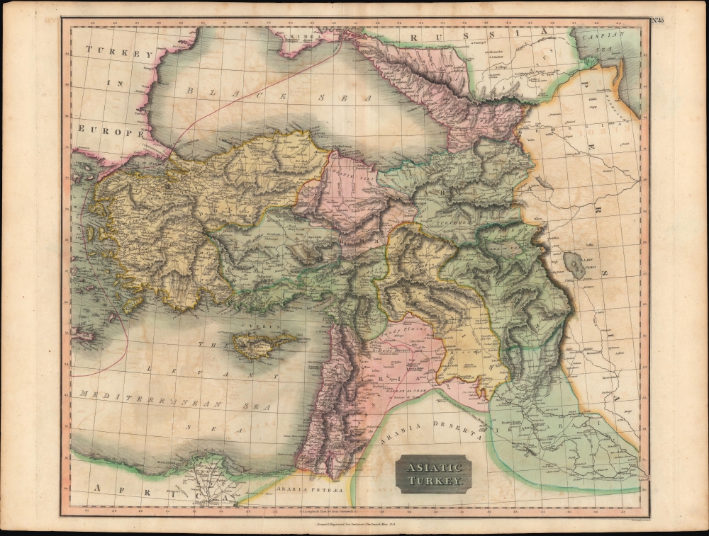
Asiatic Turkey.
1814 (dated) 20.25 x 24 in (51.435 x 60.96 cm) 1 : 4000000
1814 (dated) 20.25 x 24 in (51.435 x 60.96 cm) 1 : 4000000
Description
A fine example of John Thomson's vibrant hand-colored 1814 map of 'Asiatic Turkey,' that is, the Asian portion of the Ottoman Empire, published in his New General Atlas in 1815.
A Closer Look
Ranging from Greece to Egypt and from the Caucasus to Basrah, near the Persian Gulf in Iraq, this map lists cities, towns, and other settlements in fantastic detail. Mountains, waterways, roads, caravan routes, and other features are also noted. Ottoman provinces (eyalets) are color-shaded for easy distinction. Some hand-written annotations around Arabkir (Arapgir) in Turkey, west of Lake Van. A red line running through the Black Sea and the Mediterranean demarcated the boundary of Europe and Asia.Historical Context
When this map was produced, the Ottomans were desperately trying to shore up their frontiers in the face of multiple threats. To their north, the Russians had chipped away at their domain in a succession of wars over the preceding century. To the south, the Wahhabi movement had broken loose Ottoman control over Arabia, including the all-important holy cities of Mecca and Medina. To the west, nascent national resistance movements threatened the European portion of the Sultan's realm. And to the southwest, after regaining control of Egypt from the French, the Ottomans struggled to maintain influence as one of their own generals, Muhammad Ali, gained primacy over several rivals; he would eventually go on to found an independent dynasty that threatened the Sultanate itself (reconquering Arabia for the Sultan before doing so). Reform efforts were launched to manage these and other problems, but struggled amid factional infighting and resistance from entrenched interests, including the famed janissary corps.Publication History and Census
This map was prepared by John Thomson and engraved by Samuel John Neale (or Neele) for inclusion in Thomson's New General Atlas, which went through multiple printings in Edinburgh, London, and Dublin between 1815 and 1817. Examples of the map display different pagination (or none at all) and other minor details depending on the printing, with the plate number here (No. 45) seemingly added separately from the main plate. Compared to the example held by the David Rumsey Historical Map Collection (List No. 1007.049, published in London by Baldwin, Craddock, and Joy), the present map has a different title and slightly wider scope, including, for example, more of the Crimean Peninsula and Egypt. It is also noticeably more detailed on road networks and settlements. All these facts suggest that Thomson made an entirely new plate for the present printing, whereas plates for most other maps in the atlas were only slightly modified, if at all, for different printings.CartographerS
John Thomson (1777 - c. 1841) was a Scottish cartographer, publisher, and bookbinder active in Edinburgh during the early part of the 19th century. Thomson apprenticed under Edinburgh bookbinder Robert Alison. After his apprenticeship, he briefly went into business with Abraham Thomson. Later, the two parted ways, John Thomson segueing into maps and Abraham Thomson taking over the bookbinding portion of the business. Thomson is generally one of the leading publishers in the Edinburgh school of cartography, which flourished from roughly 1800 to 1830. Thomson and his contemporaries (Pinkerton and Cary) redefined European cartography by abandoning typical 18th-century decorative elements such as elaborate title cartouches and fantastic beasts in favor of detail and accuracy. Thomson's principle works include Thomson's New General Atlas, published from 1814 to 1821, the New Classical and Historical Atlas of 1829, and his 1830 Atlas of Scotland. The Atlas of Scotland, a work of groundbreaking detail and dedication, would eventually bankrupt the Thomson firm in 1830, at which time their plates were sequestered by the court. The firm partially recovered in the subsequent year, allowing Thomson to reclaim his printing plates in 1831, but filed again for bankruptcy in 1835, at which time most of his printing plates were sold to A. K. Johnston and Company. There is some suggestion that he continued to work as a bookbinder until 1841. Today, Thomson maps are becoming increasingly rare as they are highly admired for their impressive size, vivid hand coloration, and superb detail. More by this mapmaker...
Samuel John Neele (July 29, 1758 - May 13, 1824) was a prolific British map engraver active in the late 18th and early 19th centuries. Neele apprenticed as a printer and engraver with Harry Ashby from about 1781 to 1782 before establishing himself independently in 1785 at 352 Strand, London. The combination of business acumen and technical skill made Neele extremely successful with literally hundreds of maps to his credit. His vast corpus was composed of notable maps by most major English publishers of the period including, Haywood, Faden, Wallis, Stockdale, Arrowsmith, Thomson, Pinkerton, and Greenwood, among others. Neele's sons, James and Josiah Neele, also engravers, took over their fathers business around 1818, both becoming notable in their own right. Learn More...
Source
Thomson, J., A New General Atlas, (Edinburgh) 1817.
Thomson's New General Atlas was first published in 1817 and continued to be published until about 1821. This is the first of Thomson's major cartographic works and the atlas for which is most celebrated. The New General Atlas follows in the Edinburgh School, which eschews excessive decoration in favor of a more minimalistic fact-based cartographic vision, as established by John Pinkerton, Laurie and Whittle, John Cary, and others in the previous decades. The maps are notable for their massive scale, heavy stock, elegant color work, and easy-to-read typefaces. Although the atlas stopped being published after 1821, Thomson continued to offer 'supplementary' maps that could be tipped into the atlas as late as 1830, when he declared bankruptcy. The maps in the Thomson Atlas were engraved by Thomas Clerk, William Dassauville, Nathaniel Rogers Hewitt, James Kirkwood, Robert Kirkwood, John Menzies, George Menzies, Edward Mitchell, John Moffatt, Samuel John Neele, Robert Scott, and James Wyld.
Condition
Very good. Light foxing. Light offsetting. 1.5 inch printer's fold on bottom border.
References
Rumsey 1007.049 (variant printing).