
1943 Japan Publishing Distribution Company Map of the WWII Pacific Theater

This item has been sold.
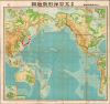
Newest Pacific Situation Map. / 最新太平洋形勢地圖
Hawaii as the nexus of Japanese WWII Pacific strategy. California as the target!
- Digital Map Information
- Suitable for large format printing
- Full resolution TIFF file
- ICC color profile embedded
- Delivered instantly via download link
Hawaii as the nexus of Japanese WWII Pacific strategy. California as the target!
This is a rare 1943 (Showa 18) large-format Japanese map of the Pacific, North and South America, and East Asia. Issued at the height of World War II, this map highlights Hawaii's significance to Japan's Pacific strategy as a nexus for all traffic, military and otherwise, between Asia and America.A Closer Look
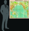
This large-format map embraces all of the Pacific from Asia to America; Australia, Oceania and the South Pacific appear in detail. It includes virtually all of North America. Insets placed in the lower left corner detail Singapore, Panama, and a profile of the Panama Canal. The upper left includes two insets: one detailing the region around Manila in the Philippines, and the other focusing on the island of Oahu, with a further detail of Pearl Harbor. The upper right-hand corner, optimistically, includes inset maps of Los Angeles and San Francisco.Japanese-claimed territories, in this case Korea, Japan, parts of Sakhalin, Taiwan, parts of Malaysia, and Micronesia, are highlighted in red. Those areas under the Japanese sphere of influence, including Manchuria, China, Burma, and Cambodia, are outlined in red. The map also highlights the Japanese Kuril Islands and several Aleutian Islands where Japanese air bases had been constructed in anticipation of action against the United States. A stamp in the upper left indicates approval by the Imperial Japanese authorities.
Publication History and Census
This map was published by the Japan Publishing Distribution Company, Ltd. (日本出版配給株式會社) in January 1943. We have handled this map only once before. These two examples are the only ones we have seen on the market or in institutional collections.Cartographer
Japan Publishing Distribution Co., Ltd. (日本出版配給株式會社; May 5, 1941 - March 28, 1949), was a nationalized joint-stock publishing company active during the World War II period in Japan. Established on May 5, 1941 (Showa 16). The government supported firm consolidated more than 200 independent publishers as a national propaganda network. The published under the guidance of the Ministry of Commerce and Industry and the Japan Publication Cultural Association. After the War, from 1946 (Showa 21), the company was returned to private management and renamed Nihon Shuppan Distribution Control Co., Ltd. The constituent firms dispersed shortly afterwards and by 1949 the Japan Publishing Distribution Co., Ltd. Some of the breakaway firms still publish. Further Details...
Condition
Very good. Toning on old fold lines; some marginal mends and repaired splits along some folds. Reinforced at intersections of some folds.