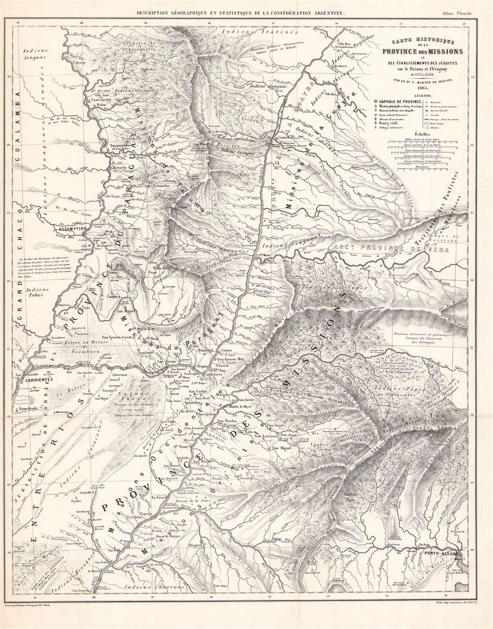
1873 Martin de Moussy Map of Paraguay
Paraguay-moussy-1873$1,200.00

Title
Carte Historique de la Province des Missions et Établissements des Jésuites sur le Parana et l'Uruguay de 1575 a 1766.
1873 (dated) 20.5 x 16.25 in (52.07 x 41.275 cm) 1 : 1870000
1873 (dated) 20.5 x 16.25 in (52.07 x 41.275 cm) 1 : 1870000
Description
This is an 1865-dated (1873) map of Paraguay and the neighboring Missions Province, an often-contested land between that country, Uruguay, and the Argentine Confederation. It was the work of French émigré physician and surveyor Martin de Moussy (Victor) who explored the region on behalf of the Argentine Confederation. It is a superbly detailed work, marking current settlements and former Jesuit ones, Indigenous regions, and the locations of battles fought in the 1851-52 Platine War, during which Martin had served in the Argentine National Guard.
A Key Borderland
The July 19, 1852, treaty between the Argentine Confederation and Paraguay (following the 1851-2 Platine War) was written to dispose of two areas: the area west of the Paraguay River, assigned to Paraguay; and the Misiones region (southeast of the Paraná River), assigned to Argentina. Despite belonging to Argentina by the treaty, the region was administered and claimed by Paraguay, Argentina having refused to ratify the treaty. Claims to these lands would remain sticking points in the relations of the nations of the La Plata region, but not so much as did the rights for travel on the rivers - over which Paraguay jealously exercised control. Following the war, Martin was assigned by Argentina to survey the Rio de la Plata as well as the Uruguay and Paraguay rivers. Following his return to France he published accounts of his travels, in particular, his 10-volume Description geographique et statistique de la confederation Argentine,in which this map was included.Publication History and Census
This map was printed by Lemercier in 1873 for inclusion in V. Martin de Moussy's 'Description geographique et statistique de la confederation Argentine, 'the first atlas of the Argentine Confederation'. The work is scarce on the market but is well represented in institutional collections.CartographerS
Victor Martin de Moussy (June 26, 1810 - March 26, 1869) was a French physician and author. In 1841 he emigrated to Rio de Janeiro, resettling to Montevideo in 1842, where he became successful in his vocation. He became rich enough to quit medicine, and became a patron of the sciences - he founded an astronomical observatory, which he donated to the city. For ten years the observatory operated with good results.
The 1846 siege of Montevideo by Rosas and Oribe led him to encourage the foundation of a foreign national guard: one French and the other Italian (and everyone else.) Martin served as physician of both legions, which mainly provided civil order during the war. The legions were dissolved with the 1852 peace. Following the war, Martin explored the Rio de la Plata on behalf of the Argentine government travelling from 1855 to 1858 surveying that river as well as the Uruguay, and Paraguay rivers. Ill health would send him back to France in 1859, where he would publish accounts of his travels, in particular his ten volume 'Description geographique et statistique de la confederation Argentine.' More by this mapmaker...
Rose-Joseph Lemercier (June 29, 1803 - 1887) was a French photographer, lithographer, and printer. One of the most important Parisian lithographers of the 19th century, Lemercier was born in Paris into a family of seventeen children. His father was a basket maker, and he even began working as a basket maker at the age of fifteen, but Lemercier was drawn to lithography and printing and soon entered into an apprenticeship with Langlumé, where he worked from 1822 until 1825. After working for a handful of other printers, Lemercier started his own firm in 1828 at 2, rue Pierre Sarrazin with only one printing press. He subsequently moved a few more times before arriving at 57, rue de Seine, where he founded the printing firm Lemercier and Company. He created the firm Lemercier, Bénard and Company in 1837 with Jean François Bénard. Lemercier bought out Bénard's share in the firm in 1843 and, since his two sons died at a young age, he decided to bring his nephew Alfred into the business beginning in 1862, who would progressively take on more and more responsibility in running the firm. Between 1850 and 1870, Lemercier's firm was the largest lithographic company in Paris. The firm began to decline in prestige in the early 1870s, and, after Lemercier's death in 1887, its descent only quickened. It is unclear when the firm closed, but Alfred directed the firm until his death in 1901. Learn More...
Source
Martin de Moussy, V., Description geographique et statistique de la confederation Argentine., (Paris: Lemercier) 1873.
Condition
Very good. Minor marginal mend, else excellent.
References
Rumsey 0464.005. OCLC 495028295, 431774434.