
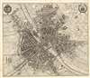
1655 Merian Map of Paris, France

This item has been sold.
Parys Ao. 1654.
Beautiful, Minutely Detailed Plan of Paris.
- Digital Map Information
- Suitable for large format printing
- Full resolution TIFF file
- ICC color profile embedded
- Delivered instantly via download link
Beautiful, Minutely Detailed Plan of Paris.
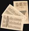
This is a 1655 Caspar Merian plan, or map of Paris, France. It appeared in Merian's Topographiae Gallae, published in Frankfurt in 1655. The plan is oriented to the south-east, centered on the Île de la Cité and Notre Dame Cathedral. The younger Merian includes in the upper corners the coats-of-arms of Paris and of France. The walled city has 793 streets, parks, and principal structures numbered to a key which appeared in the text, and which is included in full with this plan (three leaves, double-sided letterpress.) The title of the view implies that it portrays Paris 'in 1654,' and indeed it is a faithful reproduction of the four-sheet (and all-but unobtainable) Boisseau Plan général de la ville, cité, université, isles et faubourgs de Paris, which was not published until 1657 despite being dated 1648.Publication History and Census
This view was created by Caspar Merian for inclusion in his Topographiae Gallae,, published in Frankfurt am Main, in 1655 with a further editions 1661. The Topographiae is well-represented in institutional collections. Although this view does appear on the market from time to time, it is catalogued in OCLC as a separate engraving only in the Herzogin Anna Amalia Bibliothek Klassik, and the Biblioteca Nacional de Espana.Cartographer
Matthäus Merian (September 22, 1593 - June 19, 1650), sometimes referred to as 'the Elder' to distinguish from his son, was an important Swiss engraver and cartographer active in the early to mid 17th century. Merian was born in Basel and studied engraving in the centers of Zurich, Strasbourg, Nancy and Paris. In time Merian was drawn to the publishing mecca of Frankfurt, where he met Johann Theodor de Bry, son of the famed publisher Theodor de Bry (1528 - 1598) . Merian and De Bry produced a number of important joint works and, in 1617, Merian married De Bry's daughter Maria Magdalena. In 1623 De Bry died and Merian inherited the family firm. Merian continued to publish under the De Bry's name until 1626. Around this time, Merian became a citizen of Frankfurt as such could legally work as an independent publisher. The De Bry name is therefore dropped from all of Merian's subsequent work. Of this corpus, which is substantial, Merian is best known for his finely engraved and highly detailed town plans and city views. Merian is considered one of the grand masters of the city view and a pioneer of the axonometric projection. Merian died in 1650 following several years of illness. He was succeeded in the publishing business by his two sons, Matthäus (1621 - 1687) and Caspar (1627 - 1686), who published his great works, the Topographia and Theatrum Europeaum, under the designation Merian Erben (Merian Heirs). Merian's daughter, Anna Maria Sibylla Merian, became an important naturalist and illustrator. Today the German Travel Magazine Merian is named after the famous engraver. Further Details...
Source
Merian, C. Topographiae Galliae, Oder Beschreibung und Contrafaitung der vornehmbsten und bekantisten Oerter in dem mächtigen und grossen Königreich Franckreich, (Frankfurt) 1655.
Condition
Very good. Slight wear at folds, reinforced at bottom centerfold not affecting printed image, else excellent with a bold, sharp strike.
References
OCLC 1135312529. Boutier Les Plans De Paris 89.