This item has been sold, but you can get on the Waitlist to be notified if another example becomes available, or purchase a digital scan.
1919 British Admiralty Nautical Chart of the Mississippi River from New Orleans to its Mouth
PassesNewOrleans-admiralty-1919$375.00


Title
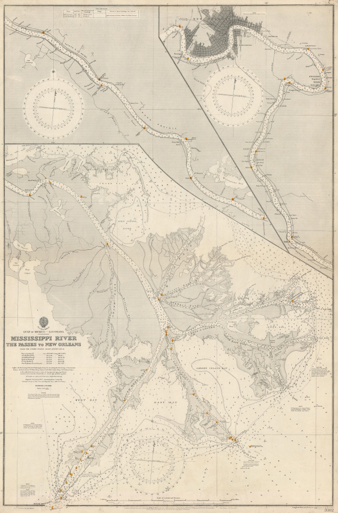
Gulf of Mexico. Louisiana. Mississippi River The Passes to New Orleans.
1919 (dated) 39.75 x 26.5 in (100.965 x 67.31 cm) 1 : 80630
1919 (dated) 39.75 x 26.5 in (100.965 x 67.31 cm) 1 : 80630
Description
This is a 1919 British Admiralty nautical chart or map of the Mississippi River from New Orleans to The Passes - thus detailing one of the most important water routes in the United States. Providing a plethora of information necessary to navigate the river, this chart offers a detailed look at the Great River.
A Closer Look
Depicting the course of the Mississippi River in three sections from New Orleans to The Passes, depth soundings, navigational lights, and settlements along the river's banks are included. The first section, from New Orleans to Deer Range, occupies the upper right. Streets are illustrated in New Orleans, with churches, City Hall, the U.S. Mint, and the Jackson Monument identifiable. Numerous railways run north from New Orleans, while only two continue south along the Mississippi. The second section of the map depicts from Harlem south to Bolivar Point, with bays, canals, and bayous identified. The third section, occupying at least two-thirds of the sheet, depict from Bayou Tourtillon to the Gulf of Mexico. The Head of Passes, the recognized mouth of the Mississippi, is labeled, before the river splits into the Pass a Loutre, South East Pass, South Pass, and South West Pass. Bays, lights, bayous, islands, and innumerable depth soundings all appear here to aid in navigating these surprisingly difficult waters. Most mouths of rivers are relatively shallow and easy to navigate, but the Mississippi Passes can prove hazardous, especially at high water.Publication History and Census
This chart was engraved by Davies and Company and published by the British Admiralty from U.S. Coast Survey in 1919. The first edition of the chart was published in 1903, with a new edition published in 1917 and small corrections published in 1918 and 1919. We have been unable to locate any examples cataloged in institutional collections, but editions of the chart appear on the market from time to time.CartographerS
The British Admiralty Office (1795 - Present) or the United Kingdom Hydrographic Office refers to the Branch of the English government that is responsible for the command of the British Navy. In 1795 King George III created the United Kingdom Hydrographic Office, known in short as the U.K.H.O., to provide top notch nautical charts to the vast Royal Navy. Prior the founding of the Admiralty the surveying and creation of nautical charts was primarily a commercial venture wherein the cartographer himself, more of than not, actually financed the printing of his own material. The great navigator Cook himself is known to have scrambled for funds to publish his own seminal charts - the most important and advanced of the period. The system of privately funded nautical mapping and publishing left vast portions of the world uncharted and many excellent charts unpublished. King George III, responding significant loss in trade revenue related to shipwrecks and delay due to poor charts, recognized the need for an institutionalized government sponsored cartographic agency - the Admiralty. The first head of the Admiralty, a position known as Hydrographer, was the important cartographer Alexander Dalrymple. Dalrymple started by organizing and cataloging obtainable charts before initiating the laborious process of updating them and filling in the blanks. The first official Admiralty Chart appeared in 1800 and detailed Quiberon Bay in Brittany. By 1808 the position of Hydrographer fell to Captain Thomas Hurd. Hurd advocated the sale of Admiralty charts to the general public and, by the time he retired in 1829, had issued and published some 736 charts. Stewardship of the organization then passed to Rear Admiral Sir Francis Beaufort. It was under Beaufort's administration that the Admiralty truly developed as a "chart making" as opposed to a "chart cataloging" institution. Beaufort held his post from 1829 to 1854. In his 25 years at the Admiralty Beaufort created nearly 1500 new charts and sponsored countless surveying and scientific expeditions - including the 1831 to 1836 voyage of the H.M.S. Beagle. By 1855 the Admiralty's chart catalog listed some 1,981 charts. More by this mapmaker...
Davies and Company (fl. c. 1880 - 1930) was an engraving and lithography firm active in London during the late 19th century. The firm engraved nautical charts for the British Admiralty Hydrographic offices in the 1880s to the early 1920s. The firm may be the successor of Davies, Bryer, and Company (fl. 1866 - 1872), who also worked with the Admiralty, which dissolved in 1872. It may also be related to the firm of Robert Davies, Maddock, and Company, which was dissolved in 1905. Their imprint, as Davies and Company, appears as early as 1880 and as late as the 1920s, but the firm may have closed its doors by that point and the imprints persist on map plates only as a legacy. Learn More...
The Office of the Coast Survey (1807 - present) founded in 1807 by President Thomas Jefferson and Secretary of Commerce Albert Gallatin, is the oldest scientific organization in the U.S. Federal Government. Jefferson created the "Survey of the Coast," as it was then called, in response to a need for accurate navigational charts of the new nation's coasts and harbors. The spirit of the Coast Survey was defined by its first two superintendents. The first superintendent of the Coast Survey was Swiss immigrant and West Point mathematics professor Ferdinand Hassler. Under the direction of Hassler, from 1816 to 1843, the ideological and scientific foundations for the Coast Survey were established. These included using the most advanced techniques and most sophisticated equipment as well as an unstinting attention to detail. Hassler devised a labor intensive triangulation system whereby the entire coast was divided into a series of enormous triangles. These were in turn subdivided into smaller triangulation units that were then individually surveyed. Employing this exacting technique on such a massive scale had never before been attempted. Consequently, Hassler and the Coast Survey under him developed a reputation for uncompromising dedication to the principles of accuracy and excellence. Unfortunately, despite being a masterful surveyor, Hassler was abrasive and politically unpopular, twice losing congressional funding for the Coast Survey. Nonetheless, Hassler led the Coast Survey until his death in 1843, at which time Alexander Dallas Bache, a great-grandson of Benjamin Franklin, took the helm. Bache was fully dedicated to the principles established by Hassler, but proved more politically astute and successfully lobbied Congress to liberally fund the endeavor. Under the leadership of A. D. Bache, the Coast Survey completed its most important work. Moreover, during his long tenure with the Coast Survey, from 1843 to 1865, Bache was a steadfast advocate of American science and navigation and in fact founded the American Academy of Sciences. Bache was succeeded by Benjamin Pierce who ran the Survey from 1867 to 1874. Pierce was in turn succeeded by Carlile Pollock Patterson who was Superintendent from 1874 to 1881. In 1878, under Patterson's superintendence, the U.S. Coast Survey was reorganized as the U.S. Coast and Geodetic Survey (C & GS) to accommodate topographic as well as nautical surveys. Today the Coast Survey is part of the National Oceanic and Atmospheric Administration or NOAA as the National Geodetic Survey. Learn More...
Condition
Very good. Light wear along original centerfold.