
This item below is out of stock, but another example (left) is available. To view the available item, click "Details."
Details
1798 Laurie and Whittle Nautical Chart or Map of Burma (Myanmar)
1798 (dated) $2,000.00
1798 Laurie and Whittle Nautical Chart or Map of Burma (Myanmar)
PeguBurma-lauriewhittle-1798$875.00

Title
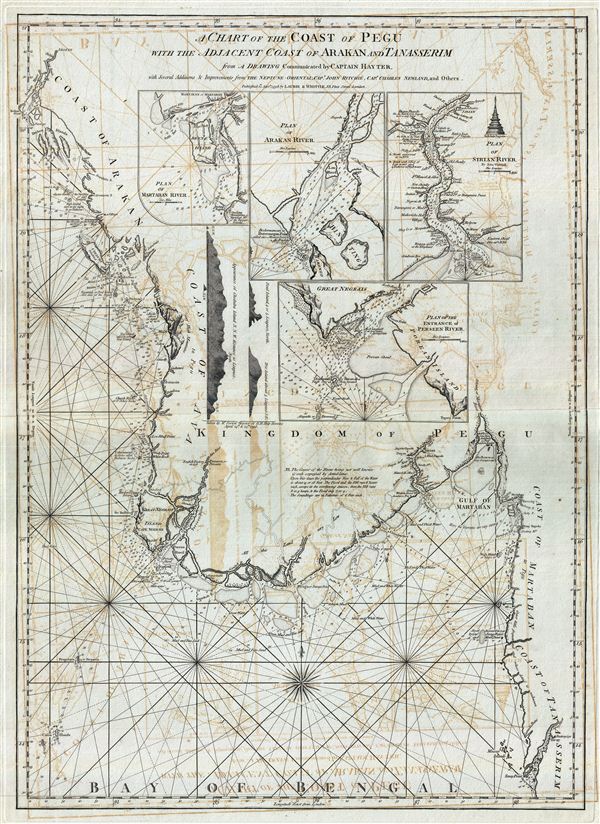
A Chart of the Coast of Pegu with the Adjacent Coast of Arakan and Tanasserim.
1798 (dated) 32 x 23 in (81.28 x 58.42 cm) 1 : 1250000
1798 (dated) 32 x 23 in (81.28 x 58.42 cm) 1 : 1250000
Description
A fine example of Laurie and Whittle's 1798 nautical chart or maritime map of Burma, Myanmar, or as it was known in the 18th century, Pegu. The map covers the western extension of Southeast Asia from the city of Arakan (today the magnificent and almost impossible to access ruin of Mrauk-U), south along the coastline to the Irrawaddy River Delta, inland to Rangoon (Yangon, here identified as Dagon, for the awe inspiring Shwedagon Pagoda), and then south past the Gulf of Martaban (Mawlamyine), to the Kyan River and Tavay Point (formerly Victoria Point, currently Kawthaung, the Thailand-Myanmar border).
The map offers rich detail including countless depth soundings, notes on the sea floor, commentary on reefs, rhumb lines, and a wealth of other practical information for the mariner. The interior is predominantly blank and annotations on the map clearly refer to a general lack of information regarding the region. Nonetheless, the 1748 site of an English factory on the Persain River (Currently Pathein, Myanmar) is identified and various inland river routes are tenuously ghosted in.
Four large inset maps fill the empty space. These include a plan of the Martaban River (modern Mawlamyine) and the sacred Buddhist shrine at Quekmay (Kyaiktiyo), the precariously balanced Golden Rock Pagoda. Another map illustrating the Arakan River entrance, though the map does not continue inland as far as the city of Arakan, today's Mrauk-U. A third plan details the Sirian River, the modern Irrawaddy River, identifying the site of Rangoon (Yangon) as Dagon. A finally the fourth inset focuses on the entrance to the Perseen River, an important trade artery developed prior Rangoon and the site of an early British trading post at Pathein. To the left of the inset maps, there are three coastal profile views.
This chart is cartographically derived from Jean-Baptiste d'Apres de Mannevillette's similar chart issued for the 1745 Neptune Oriental. It was twice reissued by Sayer and Bennet, and again, in this updated version by Laurie and Whittle, who acquired the Sayer and Bennet printing plates. The present Laurie and Whittle example is notable for several important updates by the British sea captains Hayter, Ritchie, and Newland.
Cartographer
Laurie and Whittle (fl. 1794 - 1858) were London, England, based map and atlas publishers active in the late 18th and early 19th century. Generally considered to be the successors to the Robert Sayer firm, Laurie and Whittle was founded by Robert Laurie (c. 1755 - 1836) and James Whittle (1757-1818). Robert Laurie was a skilled mezzotint engraver and is known to have worked with Robert Sayer on numerous projects. James Whittle was a well-known London socialite and print seller whose Fleet Street shop was a popular haunt for intellectual luminaries. The partnership began taking over the general management of Sayer's firm around 1787; however, they did not alter the Sayer imprint until after Sayer's death in 1794. Apparently Laurie did most of the work in managing the firm and hence his name appeared first in the "Laurie and Whittle" imprint. Together Laurie and Whittle published numerous maps and atlases, often bringing in other important cartographers of the day, including Kitchin, Faden, Jefferys and others to update and modify their existing Sayer plates. Robert Laurie retired in 1812, leaving the day to day management of the firm to his son, Richard Holmes Laurie (1777 - 1858). Under R. H. Laurie and James Whittle, the firm renamed itself "Whittle and Laurie". Whittle himself died six years later in 1818, and thereafter the firm continued under the imprint of "R. H. Laurie". After R. H. Laurie's death the publishing house and its printing stock came under control of Alexander George Findlay, who had long been associated with Laurie and Whittle. Since, Laurie and Whittle has passed through numerous permeations, with part of the firm still extant as an English publisher of maritime or nautical charts, 'Imray, Laurie, Norie and Wilson Ltd.' The firm remains the oldest surviving chart publisher in Europe. More by this mapmaker...
Source
Laurie, R., and Whittle, J., The East-India Pilot, or Oriental Navigator, on One Hundred and Eighteen Plates: Containing a Complete Collection of Charts and Plans, &c., &c. for the Navigation not only of the Indian and China Seas, but of those also between England and the Cape of Good-Hope; Improved and Chiefly Composed from the Last Work of M. D'Apres de Mannevillette; with Considerable Additions, from Private Manuscripts of the Dutch, and from Draughts and Actual Surveys Communicated By Officers of the East-India Company A New Edition, Containing One Hundred and Five Charts. (London: Laurie and Whittle) 1798.
Condition
Very good. Minor wear and verso repair along original centerfold. Original platemark visible. Some transference.
References
National Library of Australia, 3666143; MAP Ra 52.