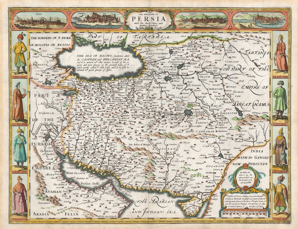
1626 John Speed 'carte á figures' Map of Persia, Afghanistan and Pakistan
Persia-speed-1676$2,200.00

Title
The Kingdome of Persia with the cheef Citties and Habites described. By John Speede.
1676 (undated) 15.5 x 20 in (39.37 x 50.8 cm) 1 : 9300000
1676 (undated) 15.5 x 20 in (39.37 x 50.8 cm) 1 : 9300000
Description
This is John Speed's map of Persia in its 1676 Bassett and Chiswell edition. This beautiful map is one of the most desirable early maps of the Near East, combining superb engraving, attractive Dutch styling, and entertaining and abundant English text. While Speed cannot be accused of innovation as a mapmaker, he was an accomplished historian and compiler. His atlases of the British Isles and the World are among the signal cartographic works of the 17th century.
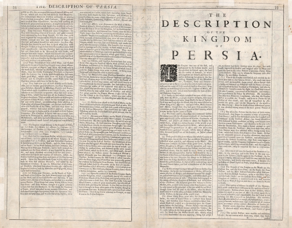
The map's verso includes Speed's historical text on the Kingdom of Persia, written in entertaining and idiosyncratic English.
The Map
The cartography for this map is drawn from the maps of Jodocus Hondius (whose student Goos engraved this map), but is unique among maps for its carte á figures borders depicting Persia's chief cities and the modes of dress of its people.Coverage
The map is centered on the Persian Empire under the Safavid Dynasty (1501 - 1736), extending eastwards to the Indus River, beyond which the 'Empire of Great Chamus' held sway. To the west, the Fertile Crescent and Arabia are part of the Ottoman Turkish Empire. The Caspian Sea is shown in the fat, ovoid form first appearing in the geography of Claudius Ptolemy. This model was not replaced until the end of the 17th century, and the Caspian Sea was not correctly depicted on a map until the 1720s. The southernmost extent of the Grand Duchy of Muscovy can be seen in the Caucasus, northwest of the Caspian. The lands west of the Volga are dominated by Tartaria: the empire of the Great Khan.Cartographic History
The map is drawn on a long-lived geographical model, only slightly changed since the mid-16th century. Speed's map was derived from that of Hondius, whose map was based on that of Ortelius - and his found its detail primarily from Giacomo Gastaldi's 1559 Il Disegno Della Prima Party Del Asia. Gastaldi's seminal map captured Persia during the first century of the Safavid Dynasty (1501 - 1736). The map's treatment of the coastline is fairly accurate, but its copious interior place names become less precise the further east and north one gets. For example, in Afghanistan, 'Cabul' appears to the south of 'Candahar.' The geography for this region, and that spanning to the east, would remain some of the most poorly understood among inhabited lands well into the 20th century.Presenting the Idea of Persia
This map displays the classic elements associated with the carte á figures as a form: key city views along the top border, along with figures to the left and right depicting the denizens of the lands. The cities are Isfahan (Spaha), Hormuz (Ormus), Tabriz in Azerbaijan (Tarvis), and what is probably the Caspian port of Bandar Anzali (Gilan, actually the name of the province) - all of these were key trade centers in the western Persian Empire. Gilan Province was the principal Asian silk exporter to the west, for example. The left and right borders display Persian and Turkish men in customary garb, paired with their respective wives.The map's verso includes Speed's historical text on the Kingdom of Persia, written in entertaining and idiosyncratic English.
The Engraver
Speed's adoption of the Dutch carte á figures map style (and indeed, the entirety of the Dutch state-of-the-art for Asian mapping) becomes unsurprising when one considers Speed's dependency on Dutch engravers. Virtually all of the maps produced for Speed during his lifetime were executed by Jodocus Hondius and (as is the case here) his protégé Abraham Goos. It would appear that until well into the 17th century, the art of engraving in the British Isles was unequal to the challenge posed by the production of maps of this quality. Not until this 1676 Bassett and Chiswell edition of Speed's work would maps be included that were actually executed by an Englishman, Francis Lamb.Publication History and Census
Although Speed died in 1629, his atlas was kept active long afterward as its plates passed from George Humble to William Garrett to Roger Rea and ultimately to Basset and Chiswell, whose final edition of 1676 is the most easily found. This 1676 edition of the separate map is only listed twice in OCLC along with a dozen of other editions. Basset and Chiswell's Theatre of the Empire of Great-Britain is well represented in institutional collections.CartographerS
John Speed (1542 - 1629) was an important English historian and cartographer active in the early 17th century. Speed was born in Fardon, Cheshire and apprenticed under his father as a tailor. Though his heart was never in tailoring, Speed dedicated himself to this profession until he was about 50 years old. During all the time, Speed dedicated his spare time to research as amateur historian and mapmaker - even preparing several maps for Queen Elizabeth. In London, Speed's interest in history lead him to join the Society of Antiquaries. Eventually he befriended the wealthy Sir Fulke Greville, who sponsored his researches and eventually freed him from the haberdashery profession. Working with William Camden, Speed eventually published his 1611 Historie of Great Britaine. Though this history itself was amateurish and of minimal importance, Speed's inclusion of numerous maps of British Cities and town was seminal. In many cases these plans were the first maps ever issued of their respective subjects. Later, turning his attention more fully to Geography, Speed published the magnificent atlas Theatre of the Empire of Great Britaine and, just prior to his death, the 1627 A Prospect of the Most Famous Parts of the World. These were the first British world atlases and have a landmark position in the history of cartography. These atlases continued to be published well after Speed's death. More by this mapmaker...
Abraham Goos (1590 - 1643) was a Dutch engraver of maps, sea charts, and globes based in Antwerp and Amsterdam. He was born in Haarlem, the sone of diamond cutter Pieter Goos and Margaret van de Keere. Through is mother he was related to engraver Pieter van den Keere (Petrus Kaerius; 1571 - 1646), the brother-in-law of map publisher Jodocus Hondius (1563 - 1612). He was likely trained in engraving by Kaerius, as his first known work is a collaboration on the 1614 terrestrial globe of Petrus Plancius. He went on to engrave for Joannes Jansson, Jocodus Hondius, and John Speed. One of his most significant works is the Holy Land map of Yaacov ben Avraham Aladdin, considered one of the earliest printed maps in Hebrew. Abraham Goos was succeeded by his son Pieter Goos (1616 - 1675), who was in tern succeeded by his son Henrik Goos. Learn More...
Source
Speed, John, The Theatre of the Empire of Great Britaine, (London: Basset and Chiswell) 1676.
Condition
Very good. Several marginal mends not impacting image; centerfold reinforced at bottom.
References
Rumsey 12058.201. OCLC 1114787704. Alai, C., General Maps of Persia 1477-1925, E. 216.