This item has been sold, but you can get on the Waitlist to be notified if another example becomes available, or purchase a digital scan.
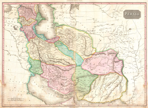
1818 Pinkerton Map of Persia ( Iran, Afghanistan )
Persia2-pinkerton-1818$225.00

Title
Persia.
1818 (undated) 21 x 28 in (53.34 x 71.12 cm)
1818 (undated) 21 x 28 in (53.34 x 71.12 cm)
Description
A rare and important 1818 map of Persia by John Pinkerton. Depicts from the Black Sea eastward as far as the Indus Valley, extends north to the Aral Sea and South to the Persian Gulf and the Arabian Sea. Includes the modern day countries of Iran and Afghanistan, as well as parts of adjacent Pakistan, Kuwait, Iraq, Turkey and Arabia. Notes both political and physical geographic elements, including rivers, mountains, under sea dangers, various tribal regions, cities, ruins, and canals. In particular, notes the ruins of both Babylon and Persepolis. Drawn by L. Herbert and engraved by Samuel Neele under the direction of John Pinkerton. The map comes from the scarce American edition of Pinkerton's Modern Atlas, published by Thomas Dobson & Co. of Philadelphia in 1818.
CartographerS
John Pinkerton (February 17, 1758 - March 10, 1826) was an Scottish writer, historian, and cartographer. Pinkerton was born in Edinburgh, Scotland. He was a studious youth with a passion for the classics. As a young man, he studied at Edinburgh University before apprenticing as a lawyer. Around this time, he began writing, with his first book, Elegy on Craigmillar Castle published in 1776. Pinkerton moved to London in 1781 to pursue his writing career in earnest. He successfully published several works of literature, poetry, and history. Pinkerton proved passionate in his literary and historical writings, but his correspondence with other cartographers has been labeled as aggressive, even insane. In addition to his work as a writer and historian, Pinkerton was one of the leading masters of the Edinburgh school of cartography which flourished from roughly 1800 to 1830. Pinkerton and his contemporaries (Thomson and Cary) redefined European cartography by abandoning typical 18th century decorative elements such as elaborate title cartouches and fantastical beasts in favor of detail and accuracy. Pinkerton's principle work is Pinkerton's Modern Atlas published from 1808 through 1815 with a special American reissue by Dobson and Co. in 1818. Pinkerton relocated to Paris in 1818, where he managed his publishing business until his death in 1826. More by this mapmaker...
Thomas Dobson (1751 - 1823) was an American publisher active in Philadelphia during the late 18th and early 19th centuries. Dobson was born in Edinburgh, Scotland in 1751 and emigrated to Philadelphia c. 1780. In Philadelphia, he established a successful printing business by republishing edited and updated versions of important British reference materials in matching quality but at a much lower price point. He is best known for publishing the first American edition of the Encyclopedia Britannica. He also published America's first Hebrew Bible. Cartographically Dobson's most notable work is 1818 republication of Pinkerton's fantastic Modern Atlas. Learn More...
Source
Pinkerton, J., A Modern Atlas, from the Lates and Best Authorities, Exhibiting the Various Divisions of the World with its chief Empires, Kingdoms, and States; in Sixty Maps, carefully reduced from the Larges and Most Authentic Sources. 1818, Philadelphia, Thomas Dobson Edition.
Condition
Good condition. Very minor damp staining lower right and left corners, mostly confined to outer margins. Original centerfold exhibits some discoloration - see photo. Blank on verso.
References
Rumsey 0732.037. Phillips (Atlases) 724. National Maritime Museum, 409.