
1945 War Office Map of Arabia, Persian Gulf Region, World War II

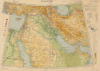
Persian Gulf. Asia Sheet 32 (1/M North F-J 36-40). M.D.R. 533/12035.
Supplying the Soviet War Effort.
- Digital Map Information
- Suitable for large format printing
- Full resolution TIFF file
- ICC color profile embedded
- Delivered instantly via download link
Supplying the Soviet War Effort.
This is a 1945 British War Office map of the Middle East, produced in the later stages of World War II (1939 - 1945). Among other features, it reflects improvements in rail and road infrastructure in Iran, which the Allies arranged to facilitate the ferrying of Lend-Lease supplies to the Soviet Union.A Closer Look
This map covers from Anatolia and Egypt in the west to Persia in the east, taking in the Levant and most of the Arabian Peninsula and Persia. Color shading indicates altitude, highlighting the highly mountainous terrain of Iran and Anatolia. A legend at the right explains the symbols, lines, and other representations of roads and paths of various qualities, railways, administrative information, ancient ruins, waterways, and terrain. At the right are also brief glossaries of Turkish, Arabic, and Persian geographic terminology. The code M.D.R. 533/12035 at the bottom-left is a reference for this specific sheet (notice the proofing color bars at the left) printed by the Middle East Drawing and Reproduction Office (M.D.R.), a cartographic section of the British Army's Middle East Forces based in Cairo.Historical Context
The Middle Eastern Theater during World War II was of important strategic value for three main reasons: control of the Suez Canal, known oil reserves in Iraq and Iran, and the usage of Iran as a conduit to ferry supplies to the Soviet Union. Nazi Germany desperately needed oil to fuel its war machine and hoped to use the Middle East as a springboard to launch a southern assault on the Soviet Union. Recognizing this threat, the Allies moved decisively in 1941, launching military campaigns to neutralize a short-lived pro-Axis government in Iraq and Vichy-aligned French authorities in Syria and Lebanon, thereby securing the region's resources and stabilizing a critical global crossroads.Although the Allies saw some setbacks in North Africa, after the Second Battle of El Alamein (October 23 - November 4, 1942), Cairo and the Suez Canal were effectively secured from Axis forces. Germany's failure to capture Moscow and other setbacks on the Eastern Front also made the prospect of a dash for Middle Eastern oil unlikely. Meanwhile, Persia emerged as the main avenue for delivering Lend-Lease aid to the Soviet Union, as Arctic convoy routes were heavily targeted by German U-boats and aircraft (and froze over for much of the year), and any Pacific route was limited by Japanese naval power. To secure this pathway, British and Soviet forces executed a joint invasion of Iran in August 1941, deposing the neutral but German-leaning Shah and opening a secure pathway from the Persian Gulf to the Soviet Union (Azerbaijan).
Over the course of the war, the Persian Corridor became a major lifeline for the Soviet Union, facilitating the transport of over 4.1 million metric tons of supplies. Under the supervision of the U.S. Army's Persian Gulf Command, engineers rapidly modernized Iran's infrastructure by expanding the capacity of the Trans-Iranian Railway, constructing thousands of miles of highways, and building aircraft assembly plants. A continuous stream of American and British trucks, tanks, fighter planes, combat rations, and industrial raw materials flooded north through rugged mountain passes into the Soviet Caucasus. This massive influx of materiel was instrumental in sustaining the Soviet war effort, directly fueling the decisive counteroffensives that turned the tide on the Eastern Front.
Publication History and Census
This map was prepared by the Geographical Section of the General Staff of the British War Office. It was first published in 1924, with a second edition in 1939. This third edition was first issued in 1941 and continually reissued throughout the war, with different printings identifiable by the 'Communications revised' information at the bottom-right. The U.S. Army Map Service also reissued the map with American military cartographic information. After the war, a fourth edition was printed between 1954 and 1961. In any printing, the map is not widely distributed in institutional collections, and the War Office (versus the A.M.S.) printing of the third edition is held only by Middlebury College and the University of Reading.Cartographer
The British War Office (1857 - 1964) was a department of the British Government responsible for the administration of the Royal Army until 1964, when its functions were transferred to the Ministry of Defense. The War Office was to the Royal Army what the Admiralty was to the Royal Navy, and later, the Air Ministry. Within the War Office, the General Staff Topographical Section was responsible for thousands of maps issued for British intelligence and military use. The Topographical Section was renamed Geographical Section in April 1907. Many, once their military use passed, were offered through licensed agents to the general public. The sole London agent for War Office material was Edward Stanford. Further Details...
Condition
Very good. Some wrinkling, toning. Light manuscript annotations in margins.
References
OCLC 1114882151.