This item has been sold, but you can get on the Waitlist to be notified if another example becomes available, or purchase a digital scan.
1630 Willem Blaeu Map of Peru
Peru-blaeu-1630$375.00

Title
Peru.
1630 (undated) 14.75 x 19.25 in (37.465 x 48.895 cm) 1 : 6500000
1630 (undated) 14.75 x 19.25 in (37.465 x 48.895 cm) 1 : 6500000
Description
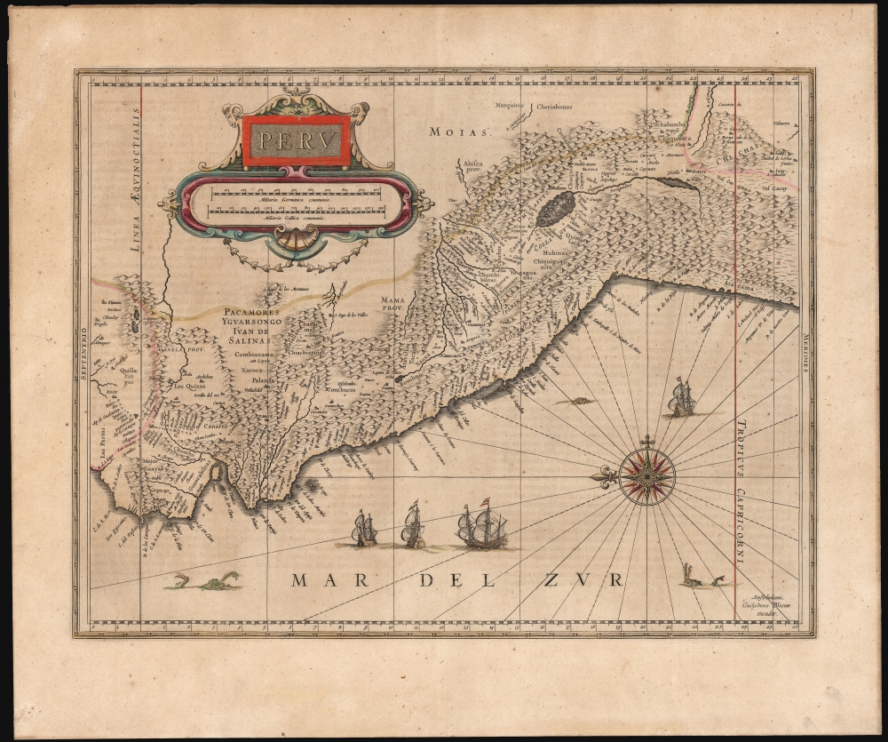
This is Willem Blaeu's beautiful 1630 map of Peru. It is among the first maps included in Blaeu's Appendix, being one of the plates Blaeu purchased from Jodocus Hondius in 1629.
A Closer Look
Representing the viceroyalty of Peru - a larger territory than the modern country - this eastern-oriented map embraces from Ecuador to northern Chile. The map's mountains, while pictorial, reflect the Andes Mountains, separating the coastal plains from inland locations. There is abundant evidence of actual exploration - much interpreted from Hessel Gerritsz' map of 1525. In particular, inland Ecuador's placenames reflect the travels of the conquistador Pedro de Cieza de Léon (1520 - 1554) during the Spanish effort to put down Pizarro's 1547-1548 rebellion. That campaign had taken him from Popayán, Colombia to Quito, and then following the coast to Lima. He then crossed the Andes to the Andahuaylas Valley. His chronicle of Peru recorded the march in detail - not only his personal experience of it, but the ruins he saw, the Inca roads, and regional natural phenomena. He was present at Pizarro's defeat at Jaquijahuana (Xaquixaguana). Although he only completed a single volume of his chronicle of Peru before his death in 1554, it remained the most detailed account of the viceroyalty. Hessel Gerritsz' map of 1625, its detail heavily drawn from Cieza de Leon's account, far surpassed Ortelius' 1584 map, considered the first specific map of Peru.The Source
This map is based on the Hessel Gerritsz map, published in 1625 by Johannes De Laet. De Laet's Nieuwe Wereldt ofte Beschrijvinghe van West-Indien was one of the earliest compilations of maps to focus on America, amounting to a prospectus for Dutch West India in that it depicted the company's intended field of operation. De Laet's work represented the first broad dissemination of the work of the West India Company's official chartmaker, Hessel Gerritsz. Hondius and his heirs, as well as Blaeu and his son, relied heavily on his work.A Beautiful Engraving
Hondius' map is not only larger than the De Laet/Gerritsz source, but it is also a more attractive presentation. It sports an elegant cartouche, including the map's scales, a superb compass rose, four sailing ships, and three sea monsters. Two of these, spouting, are whales.Publication History and Census
This map was engraved by Jodocus Hondius around 1629, and in its first state bears his imprint. He sold the plate to Blaeu, who replaced Hondius' imprint with his own. The map appeared in the Blaeu atlases with no further change until the business closed after a disasterous 1672 fire. The map is well represented in institutional collections.CartographerS
Pedro Cieza de León (1520 - 1554) was a Spanish conquistador and chronicler of Peru and Popayán. He is known primarily for his Crónicas del Perú, which would be the most detailed European report of that region well into the seventeenth century. Little is known of his youth and education. He was born to a family of Jewish conversos in Llerena, a Spanish town near the border with Portugal. At the young age of 16, having learned of the discovery of the Incas, he travelled to Seville to take ship for the Americas. Despite the prohibition of Jews and Conversos from the Spanish colonies, his family was sufficiently well establsihed for him to receive permission to go. His initial postings were in Colombia; the Popayám province, where he would participate in the foundation of several colonial cities. In 1547 he took part in Pedro de la Gasca's royalist campaign against Pizarro's rebellion, a march that took him through modern-day Ecuador and Peru, to see the war's culmination outside Cuzco and Pizarro's execution. Settling for a time in Lima, he began what was to be a four-volume history of Peru and the New World. His research would lead to further travel in the region. He returned to Seville in 1551, and there published the first volume of his work in 1553. His death the following year curtailed the publication of the rest of the work, which lay fallow until the translation of the second part 1871 by Clements Markham. The third and fourth volumes would be unearthed and published in the 20th century. More by this mapmaker...
Hessel Gerritsz (1581 – September 4, 1632) was a Dutch engraver, cartographer, and publisher active in Amsterdam during the late 16th and early 17th centuries, among the most preeminent Dutch geographers of the 17th century. He was born in Assum, a town in northern Holland in 1581. As a young man he relocated to Alkmaar to accept an apprenticeship with Willem Jansz Blaeu (1571-1638). He followed Blaeu to Amsterdam shortly afterwards. By 1610 he has his own press, but remained close to Blaeu, who published many of his maps. In October of 1617 he was appointed the first official cartographer of the Vereenigde Oost-Indische Compagnie (Dutch East Indian Company) or VOC. This strategic position offered him unprecedented access to the most advanced and far-reaching cartographic data of the Dutch Golden Age. Unlike many cartographers of his period, Gerritsz was more than a simple scholar and showed a true fascination with the world and eagerness to learn more of the world he was mapping in a practical manner. In 1628 he joined a voyage to the New World which resulted in the production of his seminal maps, published by Joannes de Laet in his 1630 Beschrijvinghe van West-Indien; these would be aggressively copied by both the Blaeu and Hondius houses, and long represented the standard followed in the mapping of the new world. Among his other prominent works are a world map of 1612, a 1613 map of Russia by the brilliant Russian prince Fyodor II Borisovich Godunov (1589 – 1605), a 1618 map of the pacific that includes the first mapping of Australia, and an influential 1630 map of Florida. Gerritsz died in 1632. His position with the VOC, along with many of his printing plates, were taken over by Willem Janszoon Blaeu. Learn More...
Jodocus Hondius (October, 14 1563 - February 12, 1612) was an important Dutch cartographer active in the late 16th and early 17th centuries. His common name, Jodocus Hondius is actually a Latinized version of his Dutch name, Joost de Hondt. He is also sometimes referred to as Jodocus Hondius the Elder to distinguish him from his sons. Hondius was a Flemish artist, engraver, and cartographer. He is best known for his early maps of the New World and Europe, for re-establishing the reputation of the work of Gerard Mercator, and for his portraits of Francis Drake. Hondius was born and raised in Ghent. In his early years he established himself as an engraver, instrument maker and globe maker. In 1584 he moved to London to escape religious difficulties in Flanders. During his stay in England, Hondius was instrumental in publicizing the work of Francis Drake, who had made a circumnavigation of the world in the late 1570s. In particular, in 1589 Hondius produced a now famous map of the cove of New Albion, where Drake briefly established a settlement on the west coast of North America. Hondius' map was based on journal and eyewitness accounts of the trip and has long fueled speculation about the precise location of Drake's landing, which has not yet been firmly established by historians. Hondius is also thought to be the artist of several well-known portraits of Drake that are now in the National Portrait Gallery in London. In 1593, Hondius returned to Amsterdam, where he remained until the end of his life. In 1604, he purchased the plates of Gerard Mercator's Atlas from Mercator's grandson. Mercator's work had languished in comparison to the rival atlas, Theatrum Orbis Terrarum by Ortelius. Hondius republished Mercator's work with 36 additional maps, including several which he himself produced. Despite the addition of his own contributions, Hondius recognizing the prestige of Mercator's name, gave Mercator full credit as the author of the work, listing himself as the publisher. Hondius' new edition of Mercator revived the great cartographer's reputation and was a great success, selling out after a year. Hondius later published a second edition, as well as a pocket version called the Atlas Minor. The maps have since become known as the "Mercator/Hondius series". Between 1605 and 1610 Hondius was employed by John Speed to engrave the plates for Speed's The Theatre of the Empire of Great Britaine. Following Hondius' death in 1612, his publishing work in Amsterdam was continued by his widow and two sons, Jodocus II and Henricus. Later his family formed a partnership with Jan Jansson, whose name appears on the Atlasas co-publisher after 1633. Eventually, starting with the first 1606 edition in Latin, about 50 editions of the Atlas were released in the main European languages. In the Islamic world, the atlas was partially translated by the Turkish scholar Katip Çelebi. The series is sometimes called the 'Mercator/Hondius/Jansson' series because of Jansson's later contributions. Hondius' is also credited with a number of important cartographic innovations including the introduction of decorative map borders and contributions to the evolution of 17th century Dutch wall maps. The work of Hondius was essential to the establishment Amsterdam as the center of cartography in Europe in the 17th century. Learn More...
Willem Janszoon Blaeu (1571 - October 18, 1638), also known as Guillaume Blaeu and Guiljelmus Janssonius Caesius, was a Dutch cartographer, globemaker, and astronomer active in Amsterdam during the late 16th and early 17th centuries. Blaeu was born 'Willem Janszoon' in Alkmaar, North Holland to a prosperous herring packing and trading family of Dutch Reformist faith. As a young man, he was sent to Amsterdam to apprentice in the family business, but he found the herring trade dull and instead worked for his cousin 'Hooft' as a carpenter and clerk. In 1595, he traveled to the small Swedish island of Hven to study astronomy under the Danish Enlightenment polymath Tycho Brahe. For six months he studied astronomy, cartography, instrument making, globe making, and geodesy. He returned to Alkmaar in 1596 to marry and for the birth of his first son, Johannes (Joan) Blaeu (1596 – 1673). Shortly thereafter, in 1598 or 1599, he relocated his family to Amsterdam where he founded the a firm as globe and instrument makers. Many of his earliest imprints, from roughly form 1599 - 1633, bear the imprint 'Guiljelmus Janssonius Caesius' or simply 'G: Jansonius'. In 1613, Johannes Janssonius, also a mapmaker, married Elizabeth Hondius, the daughter of Willem's primary competitor Jodocus Hondius the Elder, and moved to the same neighborhood. This led to considerable confusion and may have spurred Willam Janszoon to adopt the 'Blaeu' patronym. All maps after 1633 bear the Guiljelmus Blaeu imprint. Around this time, he also began issuing separate issue nautical charts and wall maps – which as we see from Vermeer's paintings were popular with Dutch merchants as decorative items – and invented the Dutch Printing Press. As a non-Calvinist Blaeu was a persona non grata to the ruling elite and so he partnered with Hessel Gerritsz to develop his business. In 1619, Blaeu arranged for Gerritsz to be appointed official cartographer to the VOC, an extremely lucrative position that that, in the slightly more liberal environment of the 1630s, he managed to see passed to his eldest son, Johannes. In 1633, he was also appointed official cartographer of the Dutch Republic. Blaeu's most significant work is his 1635 publication of the Theatrum orbis terrarum, sive, Atlas Novus, one of the greatest atlases of all time. He died three years later, in 1638, passing the Blaeu firm on to his two sons, Cornelius (1616 - 1648) and Johannes Blaeu (September 23, 1596 - December 21, 1673). Under his sons, the firm continued to prosper until the 1672 Great Fire of Amsterdam destroyed their offices and most of their printing plates. Willem's most enduring legacy was most likely the VOC contract, which ultimately passed to Johannes' son, Johannes II, who held the position until 1617. As a hobbyist astronomer, Blaeu discovered the star now known as P. Cygni. Learn More...
Source
Blaeu, W., Théâtre du Monde ou Nouvel Atlas, (Amsterdam: Blaeu) 1640.
The classic Dutch atlas, whose publication ushered in the Dutch golden age of cartography. Willem Jansz Blaeu had been, since 1604, producing engraved maps for sale; these were separate issues (and all consequently extremely rare) until the publishing of Blaeu's Appendix in 1630 and 1631, which also included a number of maps purchased from the widow of Jodocus Hondius, (for example his famous iteration of John Smith's map of Virginia.) In 1634, he announced his intention to produce a new world atlas in two volumes, entitled Theatrum Orbis Terrarum, sive Atlas Novus (Théâtre du Monde ou Nouvel Atlas) (in an effort to invoke the successful work of the same title produced by Ortelius the previous century, while reinforcing the notion of it being a new work.) This work was published first in German in 1634, followed by Latin, Dutch and French editions in 1635. Blaeu's maps have always been noted for the quality of their paper, engraving and fine coloring, and this was the intent from the very start. The 1634 announcement of the upcoming work described it: 'All editions on very fine paper, completely renewed with newly engraved copperplates and new, comprehensive descriptions.' (van der Krogt, p,43) Many of the most beautiful and desirable maps available to the modern collector were printed and bound in Blaeu's atlases. Willem's son, Joan, would go on to add further volumes to the Atlas Novus, concurrently printing new editions of the first two volumes with additional maps, in effect making these new editions an entirely new book. Under Joan there would be nine Latin editions, twelve French, at least seven Dutch, and two German. This exceedingly successful work would be the mainstay of the Blaeu firm until 1661, at which point the work was supplanted by Joan Blaeu's masterwork Atlas Maior in 1662.
Condition
Very good. Even overall toning and specking. Else excellent with beautiful original color.
References
OCLC 431572057. Rumsey 12202.066 (1630 Appendix edition) Van der Krogt, Peter, Koeman's Atlantes Neerlandici, Vol. II, 9820:2.2 1640 Latin.