1700 Schenk and Valk Map of Peru
Peru-schenkvalk-1700$400.00

Title
Peru.
1700 (undated) 15.25 x 19.5 in (38.735 x 49.53 cm) 1 : 7000000
1700 (undated) 15.25 x 19.5 in (38.735 x 49.53 cm) 1 : 7000000
Description
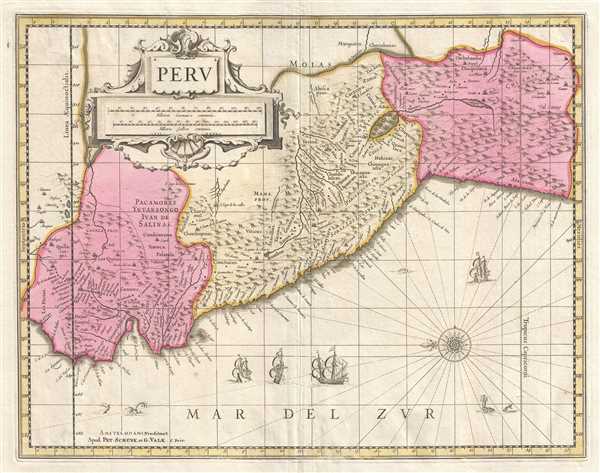
This is a c. 1700 Pieter Schenk and Gerard Valk map of Peru. The map, oriented towards the east, depicts the region from Los Pastos to Val Xuxuy and from an area east of Peru along the Omapalchas River and home to the Marquires and Cheriabonas Indians to the Pacific Ocean. Highly detailed, myriad cities, towns, and villages are labeled, along with the names of numerous Indian tribes native to the region. Lake Titicaca is prominently illustrated, as are the Andes, which extend along the length of Peru. Intriguingly, as the map progresses further and further to the east, into the Amazon, the map become blank, indicating the complete lack of knowledge about the region. Beautiful sailing ships are included in the Pacific, close to a ghastly sea monster. A decorative cartouche bearing the map's title and scale is situated in the upper left corner.
This map was published by Pieter Schenk and Gerard Valk c. 1700. This map was originally published by Hondius, whose plates were acquired by Schenk and Valk in 1694.
This map was published by Pieter Schenk and Gerard Valk c. 1700. This map was originally published by Hondius, whose plates were acquired by Schenk and Valk in 1694.
CartographerS
Petrus Schenk (Pieter Schenck) the Elder (December 26, 1660 - 1711) was a Dutch engraver, globe maker, and map publisher active in Amsterdam and Leipzig in the latter half of the 17th century. Schenk, was born in Elberfield, Germany. He moved in Amsterdam in 1675, becoming the apprentice to Gerard Valk (Valck). In 1687, Schenk married Agatha Valk, Gerard Valk's sister and went into partnership with his brother-in-law under the imprint of 'Valk and Schenk'. Initially they focused on maps and atlases, acquiring the map plates of Jan Jansson and Jodocus Hondius in 1694. Later, in 1701 they moved into the former Hondius offices where they began producing globes. Valk and Schenk quickly became known for producing the best globes in the Netherlands, a business on which they held a near monopoly for nearly 50 years. Schenk's three sons, Pieter Schenk the Younger, Jan Schenk, and Leonard Schenk, all became engravers in their own right. Pieter Schenk the Younger inherited the business and ran his father's shop in Leipzig. His daughter, Maria Schenk, married Leonard Valk, the son of Gerard Valk, and continued to run the Valk and Schenk map engraving workshop in Amsterdam. More by this mapmaker...
Gerard Valk (September 30, 1652 - October 21, 1726) (aka. Valck, Walck, Valcke), was a Dutch engraver, globe maker, and map publisher active in Amsterdam in the latter half of the 17th century and early 18th century. Valk was born in Amsterdam where his father, Leendert Gerritsz, was a silversmith. He studied mathematics, navigation, and cartography under Pieter Maasz Smit. Valk and moved to London in 1673, where he studied engraving under Abraham Blooteling (or Bloteling) (1634 - 1690), whose sister he married, and later worked for the map sellers Christopher Browne and David Loggan. Valke and Blooteling returned to Amsterdam in 1680 and applied for a 15-year privilege, a kind of early copyright, from the States General, which was granted in 1684. In 1687, he established his own firm in Amsterdam in partnership with Petrus (Pieter) Schenk, who had just married his sister, Agata. They published under the imprint of Valk and Schenk. Also, curiously in the same year Valk acquired the home of Jochem Bormeester, also engraver and son-in-law of art dealer Clement De Jonghe. Initially Valk and Schenk focused on maps and atlases, acquiring the map plates of Jodocus Hondius and Jan Jansson in 1694. Later, in 1701 they moved into the former Hendrick Hondius (the younger) offices where they began producing globes. Valk and Schenk soon acquired the reputation of producing the finest globes in the Netherlands, a business on which they held a near monopoly for nearly 50 years. In 1702, Valk joined the Bookseller's Guild of which he was promptly elected head. Around the same time, Gerard introduced his son, Leonard, who was married to Maria Schenk, to the business. Leonard spearheaded the acquisition of the map plates of Frederick de Wit in 1709. Nonetheless, Leonard was nowhere near as sophisticated a cartographer or businessman as his father and ultimately, through neglect, lost much the firm's prestige. After his death, the firm was taken over by his widow Maria. Learn More...
Jodocus Hondius (October, 14 1563 - February 12, 1612) was an important Dutch cartographer active in the late 16th and early 17th centuries. His common name, Jodocus Hondius is actually a Latinized version of his Dutch name, Joost de Hondt. He is also sometimes referred to as Jodocus Hondius the Elder to distinguish him from his sons. Hondius was a Flemish artist, engraver, and cartographer. He is best known for his early maps of the New World and Europe, for re-establishing the reputation of the work of Gerard Mercator, and for his portraits of Francis Drake. Hondius was born and raised in Ghent. In his early years he established himself as an engraver, instrument maker and globe maker. In 1584 he moved to London to escape religious difficulties in Flanders. During his stay in England, Hondius was instrumental in publicizing the work of Francis Drake, who had made a circumnavigation of the world in the late 1570s. In particular, in 1589 Hondius produced a now famous map of the cove of New Albion, where Drake briefly established a settlement on the west coast of North America. Hondius' map was based on journal and eyewitness accounts of the trip and has long fueled speculation about the precise location of Drake's landing, which has not yet been firmly established by historians. Hondius is also thought to be the artist of several well-known portraits of Drake that are now in the National Portrait Gallery in London. In 1593, Hondius returned to Amsterdam, where he remained until the end of his life. In 1604, he purchased the plates of Gerard Mercator's Atlas from Mercator's grandson. Mercator's work had languished in comparison to the rival atlas, Theatrum Orbis Terrarum by Ortelius. Hondius republished Mercator's work with 36 additional maps, including several which he himself produced. Despite the addition of his own contributions, Hondius recognizing the prestige of Mercator's name, gave Mercator full credit as the author of the work, listing himself as the publisher. Hondius' new edition of Mercator revived the great cartographer's reputation and was a great success, selling out after a year. Hondius later published a second edition, as well as a pocket version called the Atlas Minor. The maps have since become known as the "Mercator/Hondius series". Between 1605 and 1610 Hondius was employed by John Speed to engrave the plates for Speed's The Theatre of the Empire of Great Britaine. Following Hondius' death in 1612, his publishing work in Amsterdam was continued by his widow and two sons, Jodocus II and Henricus. Later his family formed a partnership with Jan Jansson, whose name appears on the Atlasas co-publisher after 1633. Eventually, starting with the first 1606 edition in Latin, about 50 editions of the Atlas were released in the main European languages. In the Islamic world, the atlas was partially translated by the Turkish scholar Katip Çelebi. The series is sometimes called the 'Mercator/Hondius/Jansson' series because of Jansson's later contributions. Hondius' is also credited with a number of important cartographic innovations including the introduction of decorative map borders and contributions to the evolution of 17th century Dutch wall maps. The work of Hondius was essential to the establishment Amsterdam as the center of cartography in Europe in the 17th century. Learn More...
Condition
Very good. Even overall toning. Verso reinforcement along original centerfold. Blank on verso.
References
Koeman 9820:1. OCLC 166645035.