
1966 Roberts Pictorial Map of the Philippines


This item has been sold.
Republic of the Philippines.
The Philippines in the Early Marcos Era
The Philippines in the Early Marcos Era
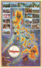
This is a colorful, large-format 1966 pictorial map of the Philippines by Mike Roberts. Produced as the U.S. ramped up its involvement in the Vietnam War (1955 - 1975), it presents the magnificent diversity of the archipelago to an American audience.A Closer Look
The map covers the archipelago constituting the Republic of the Philippines, labeling major islands and cities and tracing highways. Illustrations throughout depict local cultures, climates, and history, including the U.S. fortress on Corregidor Island, which famously held out in the opening weeks of the Pacific War in World War II. At the top, similarly themed photographs are integrated, depicting scenes from Manila, Mindanao, and the countryside.The Philippines in the Early Marcos Era
This map was produced in the early years of the turbulent presidency of Ferdinand Marcos, which evolved into a 20-year dictatorship. At this point, though, Marcos was popular and restrained in his powers. In a pattern common for U.S. allies at the time, the Philippines underwent large-scale infrastructure modernization with U.S. assistance and foreign loans, including the creation of the North Luzon Expressway and ongoing work on the Maharlika / Pan-Philippine Highway. The result was that the Philippines was fairly prosperous - the second largest economy in Asia after Japan - but the high levels of spending on infrastructure and the military set off an inflationary crisis which became a political and social crisis, resulting in Marcos' imposition of martial law in 1972.Atypically for U.S. allies in Asia (such as South Korea, Taiwan, and Thailand), Marcos was deeply unenthusiastic about the American war in Vietnam and tried to resist pressure from the U.S. to send ground forces. Eventually, a small force of several hundred Filipino troops was sent to South Vietnam, where they performed civilian aid and engineering work.
The mention of the 'ancient Moslem ways of Mindanao' here is noteworthy, as the island would soon be riven by religious tensions and insurgency. Marcos encouraged Christian migrants to move to Mindanao, resulting in land disputes with the mostly Muslim indigenous population. Marcos then urged the migrants to set up a militia called the Ilaga, which was accused of wanton violence against Muslims. When Marcos launched a secret mission to foment unrest in Malaysia's Sabah state in North Borneo (at bottom here), a group of Moro army recruits mutinied and were massacred by Filipino Army regulars. Despite being covered up, news of the incident gradually leaked out and helped set off a full-scale insurgency among the Moro on Mindanao, which continued in some form until 2019 and still threatens to reignite.
Publication History and Census
This map was prepared by Mike Roberts in 1966 and is accompanied here by its original mailer. We have been unable to locate this map in any institutional collections, and it only rarely appears on the market.Cartographer
Mike Roberts (19xx - 1989) was an American photographer and publisher, and was known as 'America's Postcard King'. Roberts left home at sixteen with twenty-five dollars, a box camera, and his Harley. Roberts arrived in the Bay Area in 1934 and began working as a photographer in Berkeley. By 1941 he was a partner in the Litho Screen Company in Oakland, which was also likely his first venture into the printing trade. Robert's first traceable postcard is postmarked June 12, 1945, and bears one of his photographs of the Yosemite Valley. Roberts used a handful of different publishers before he founded 'Mike Roberts Color Productions' in 1949, which marks his move into the world of commercial postcard production. Over the course of his career, Roberts used numerous different logos and his postcards were published by several different publishers. Roberts died in 1989 and his company continued operating until 1998. Further Details...
Condition
Very good. Upper right recornered in margins.