
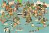
1950 Wijga Ethnographic and Wildlife Pictorial Map of the World


This item has been sold.
[Map of the World].
Pageant of life on Earth.
- Digital Map Information
- Suitable for large format printing
- File Size: 63.93 MB
- File Type: ZIP / TIFF
- ICC color profile embedded
- Delivered instantly via download link
Pageant of life on Earth.
This is a 1950 Jan Wijga pictorial map of the world. Presenting a dynamic mix of the world's people and wildlife, the map depicts the world divided into hemispheres. Although unaccompanied by its index, 150 different people and animals are illustrated. Portraits portray the pageant of humanity. For example, a cowboy and a Native American are illustrated in North America, along with a member of the Royal Canadian Mounted Police near Vancouver, and a fisherman in Newfoundland. Portraits in South America and Africa focus on tribal societies. Asians wear traditional costumes and jewelry. The world's great architecture is also on display, from the skyscrapers of America's East Coast to the iconic onion domes of Saint Basil's Cathedral in Moscow, the Pyramids at Giza, and the Taj Mahal. Large illustrations of a bear, wolf, camel, reindeer and kangaroo are among the fauna illustrated. The whole is a wonderful summary of life on Earth.Publication History and Census
This map was created by Jan Wijga and copyrighted by Luii and Company in Amsterdam in 1950. Scarce.Cartographer
Jan Wijga (December 13, 1902 - December 10, 1978), aka Wyga, was a Dutch Art Deco painter, designer, and illustrator active in Holland in the middle part of the 20th century. Wijga worked extensively for KNILM (Royal Dutch Indies Airways) and various beer companies, producing posters and other highly graphic promotional material. We are aware of only 3 cartographic images by Wijga, a map of KNILM routes, a smaller but similar map focusing on Bali/Lombok, and an ethnographic game-map of the world. Wijga's work is typically considered in the context of with other European commercial artists who rose to prominence during the interwar period, including Lucien Boucher, Otto Arpke, Jean Carlu, Paul Colin, and Albert Solon, among others. Their work took advantage of advancements in color printing made before and during World War I (1914 - 1918) to issue stunning large format maps with large intense solid color blocks and eye-popping graphics. Further Details...
Condition
Very good. Even overall toning. Wear along margins. Closed margin tears professionally repaired on verso.
References
Rumsey 11648.000. OCLC 41348111.