1795 Carey / Barker Map of Poland, Lithuania, Eastern Europe
Poland-carey-1795$400.00
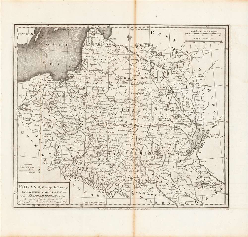

Title
Poland, shewing the claims of Russia, Prussia and Austria until the late depredations, the extent of which cannot as yet be ascertained.
1795 (undated) 15.75 x 16.5 in (40.005 x 41.91 cm) 1 : 3700000
1795 (undated) 15.75 x 16.5 in (40.005 x 41.91 cm) 1 : 3700000
Description
Here is Matthew Carey and William Barker's c. 1795 map, for Carey's General Atlas, of that lands that had composed the Polish-Lithuanian Commonwealth, which were broken up and distributed to Austria, Prussia, and Russia in the late 19th century. Aside from its cartographic qualities, this map is an instructive case study in knowledge production at a time of considerable change and instability.
The claims of Russia, Prussia, and Austria are indicated with numbers. Regions shown include Great Poland and Little Poland at left, the Great Duchy of Lithuania at right-center, Courland and Samogitia to its north, and Volhynia, Galicia, Ukraine (including Kyiv, here as Kiow), 'Red Russia' (Red Ruthenia, along today's Ukraine-Poland border), Moldavia, and Podolia to the south.
A Closer Look
This map shows the lands that had belonged to the Polish-Lithuanian Commonwealth, an entity which ceased to exist the same year the map was made. Characteristic of the Carey atlas, longitude is shown from both London and Philadelphia (where the atlas was produced and published), while scales are given in Polish and British statute miles. Mountains, rivers, lakes, forests, and borders are shown, along with settlements, distinguished according to size and function by different symbols.The claims of Russia, Prussia, and Austria are indicated with numbers. Regions shown include Great Poland and Little Poland at left, the Great Duchy of Lithuania at right-center, Courland and Samogitia to its north, and Volhynia, Galicia, Ukraine (including Kyiv, here as Kiow), 'Red Russia' (Red Ruthenia, along today's Ukraine-Poland border), Moldavia, and Podolia to the south.
Poland - Stuck between Great Powers
The Polish-Lithuanian Commonwealth suffered at the hands of Russia, Prussia, and Austria in the 18th century when the three states conspired to reduce and then eliminate the commonwealth, a feat accomplished between 1772 and 1795. But Polish nationalism had been enflamed by the American and French Revolutions, and the Napoleonic Wars offered an opportunity to recreate a Polish state. Following a popular uprising in 1806, Napoleon carved off a portion of Prussia to create the Duchy of Warsaw. However, the duchy was a French client state with limited autonomy, and was short lived in any case, having been occupied by Russia in 1813 following Napoleon's disastrous invasion of Russia the previous year. Poland (and Lithuania) would be reborn and reconquered over the following two centuries, and, with additional border changes in the 20th century, Poland 'shifted' considerably to the west. Warsaw, at left-center here, is now in the eastern part of the country, while Brest, slightly left of center here, is no longer part of Poland at all but was at the western edge of Belarus.Publication History and Census
This map was engraved by William Barker for Carey's General Atlas (sometimes subtitled American Edition of Guthrie's Geography improved). Dating this map is difficult, as it was included in the first (1795) edition of Carey's atlas and left unchanged through the 1811 edition, perhaps because the status of the Polish and Lithuanian lands was so in flux between those years. In fact, whether as a political statement or due to a lack of information or certainty about future developments, the numbers indicating the claims of Russia, Prussia, and Austria here correspond to those following the First Partition of Poland in 1772, but not the Second Partition in 1775 (when Prussia seized Danzig / Gdansk and lands to the west of Warsaw and Russia took a vast swath of territory west of Kyiv and around Minsk). The distribution of this map is difficult to firmly establish, both due to uncertainty over its date and because the OCLC catalog listing includes digitized copies along with physical examples. Both the individual map and the entire atlas are held by a handful of universities and research institutions in the United States and Europe, while the map is scarce to the market.CartographerS
William Barker (June 29, 1770 - April 19, 1805) was an engraver active in Philadelphia un the late 18th and early 19th centuries. Barker was born in Philadelphia, the son of Elihu Barker (17?? - 1792). Both father and son worked for the firm of Mathew Carey (1760 - 1839) and engraved maps for Carey's American Atlas, considered the first general atlas published in America. He appears in Philadelphia directories for 1795 - 1796 and 1800 - 1809. His business may have been carried on by a son of the same name, but it is unclear. More by this mapmaker...
Matthew Carey (January 28, 1760 - September 16, 1839) was a Dublin born publisher who established himself in Philadelphia in the late 18th and early 19th century. A young man of socially progressive views, Carey's first known publication, produced when he was but 17 years old, was a pamphlet criticizing dueling. Another pamphlet, issued in the same year, attacked the Irish penal code. Shortly afterwards, in 1779, legal issues, possibly arising from his liberal political activism, forced Carey to flee to Paris. In Paris, Carey had the good fortune to befriend the visiting American diplomat and founding father, Benjamin Franklin (1706 - 1790). As an Irishman chafing under the rule of England, Carey sympathized with and admired the American revolutionary. The liberally minded pair struck up a lifelong friendship and Carey was hired to work at Franklin's press in Passy, France. A year later, Carey returned to Ireland and resumed his politically provocative publishing career with The Freemans's Journal and The Volunteer's Journal. It didn't take long for political pressure to once again force Carey from Ireland - this time to America (1784). Although largely without funds, Carey convinced Gilbert du Motier, Marquis de Lafayette (1757 - 1834), who he knew from Franklin's Paris circle, to lend him funds to establish a new publishing concern in Philadelphia. Despite this loan, Carey's firm remained under financed and opened on a shoestring budget. It was most likely his limited budget that led Carey to some of his most important publishing innovations. At the time cartographic publishing was dominated by large printing houses in London and Paris where most, if not all, of the work was completed in house. Without the finances to emulate this large publishing houses, Carey was forced to outsource much of his publishing work. This set the stage for subsequent American publishers who, in order to compete effectively with European firms, relied on an often bewildering network of alliances and collaborations. Carey was also a master of republishing many of his own maps in multiple different atlases and formats to maximize their profitability. His most important work is without a doubt the 1795 issue of the American Atlas the first atlas to be published in America. Carey died in 1839 but was succeeded by his son Henry Charles Carey (1793 - 1879) who, in partnership with his brother-in-law Isaac Lea (1792 - 1886), published numerous important maps and atlases under the Carey and Lea, Lea Brothers, and Lea and Blanchard imprints. Learn More...
William Guthrie (1708 - March 9, 1770) was a Scottish historian, journalist, and writer. Born in Brechin, he studied at Aberdeen University with the idea of becoming a parochial schoolmaster. Instead, in 1730, he elected to settle in London and try his hand at literature. He covered parliamentary debates f or the Gentleman's Magazine and soon earned a reputation for being a political writer. He published several scholarly works, including a History of England from the Invasion of Julius Caesar to 1688 in four volumes, and, most notably, his Geographical Historical, and Commercial Grammar. Learn More...
Source
Carey, M., Carey's General Atlas, (Philadelphia: Carey) 1796.
Condition
Good. Minor discoloration at centerfold.
References
Rumsey 4863.018. OCLC 921155168.