
1930 American Geographical Society Maps of Polar Exploration

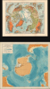
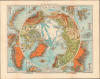
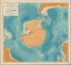
Physical Map of the Arctic. / Bathymetric Map of the Antarctic / Two Polar Maps with Notes on Recent Polar Exploration.
Aviation and Polar Exploration.
- Digital Map Information
- Suitable for large format printing
- Full resolution TIFF file
- ICC color profile embedded
- Delivered instantly via download link
Aviation and Polar Exploration.
This is a pair of 1929 maps of the Arctic and Antarctic, respectively, published in a 1930 report of the American Geographical Society to illustrate the significance of aviation to Polar Exploration. At the time, they represented the most detailed and up-to-date maps of the polar regions. These maps are accompanied by a report titled Brief History of Polar Exploration since the Introduction of Flying.A Closer Look
The 'Physical Map of the Arctic' measures 19.75 x 15.5 inches with wide margins. It is handsomely designed with a main circular map in polar projection surrounded by eleven insets, depicting Novaya Zemblya, Smith Sound to Robeson Channel, Southern Greenland, Jan Mayen Island, Bear Island, Ice Fiord, Spitsbergen, Franz Josef Land, Eastern Greenland, Bering Strait, and Northernmost Greenland. The main map traces the routes of explorers, from Nansen's 1895 expedition up to Nobile's ill-fated 1928 Italia airship expedition, the search for which led to the deaths of several other Polar explorers, including the famed Roald Amundsen. A legend at the bottom explains symbols used across all the maps, while shading is used to indicate elevation.The map of the Antarctic (measuring 25.25 x 23.5 inches), also in polar projection, is focused less on the continent itself than the waters and ice surrounding it, using shading to indicate depth/ bathymetry. Different types of lines are used to display glaciers, ice shelves, and the extent of sea ice depending on the season. Territorial claims are also noted; these were frozen (though not abrogated) by the 1959 Antarctic Treaty, which prohibited new claims and designated the continent for peaceful, scientific purposes.
Historical Context
Around 1930, the race for the poles was largely over - Peary and Amundsen having already claimed the North and South Poles - but the scientific mapping of the polar interiors had only just begun. Exploration shifted from simple 'firsts' to systematic geographical survey, aided by new technologies, including automobiles, icebreaker ships, airplanes, and airships, to replace the grueling, man-hauled sledge journeys of the earlier 'Heroic Age.' Rather than an explorer assembling a team and scrambling to raise donations, which may or may not have been forthcoming from the likes of the respective governments of the expedition leaders, institutions like the American Geographical Society distinguished themselves as permanent centers designed to finance polar expeditions of the new sort. The maps seen here were an important synthesis of all available scientific data about the Arctic and Antarctic, compiled by Joerg, who had been hired by the AGS in 1911 and was the first true geographic professional to work there. They were part of a wider push by the AGS at the end of the 1920s to demonstrate their leading role in polar research (see also our earlier listings, AntarcticaWilkinsHearst-ags-1929 and queenmaudmtns-americangeo-1931).Publication History and Census
These maps were prepared by the American Geographical Society in 1929 for publication in a special supplement titled Two polar maps with Notes on Recent Polar Exploration, which accompanied a 1930 report titled Brief History of Polar Exploration since the Introduction of Flying. The Arctic map was adapted from a German-language map in Andrees Allgemeiner Handatlas, while the Antarctic map was printed by August Hoen. Catalog listing are understandably inconsistent, some noting the maps individually, others using the title of one of the maps but referring to the entire supplement, some listing the maps in the supplement together under the title Two polar maps with Notes on recent polar exploration, and some the entire work under the title of the Brief History…. The maps also maintain a different date than the Brief History…, and at least two editions were printed, making matters more complicated. Harvard University, Yale University, the University of Wisconsin - Milwaukee, Deakin University, the State Library of Western Australia, and the Delft University of Technology are recorded as holding the first edition of the maps, cataloged in any of these fashions, in the OCLC. An example is also held by the David Rumsey Historical Map Collection (dated 1930 based on the Brief History…).Cartographer
The American Geographical Society (AGS) (1851 - Present) is an organization founded in in New York City 1851 by thirty-one New Yorkers. Organized to search for the lost Franklin Expedition, the search for Franklin proved unsuccessful. However, the AGS remained, and members played roles in surveying for the transcontinental railway and supported continued exploration efforts. Its main areas of focus were the Arctic, Antarctic, and Latin America and any exploration it sponsored was required to produce tangible scientific results. Today, after nearly 175 years, the AGS is still in operation and focuses its energy on promoting geographical education. Further Details...
Condition
Good. Wear along fold lines of Arctic map. Pinholes in the corners of Antarctic map, with a couple ink smudges in the margins.
References
Rumsey 10951. OCLC 84177984, 1050162430, et al.