This item has been sold, but you can get on the Waitlist to be notified if another example becomes available, or purchase a digital scan.
1857 U.S.C.S. Map of Boston's North Shore ( Cape Ann, Boston, Portsmouth)
PortlandMainetoRacePoint2-uscs-1857$150.00

Title
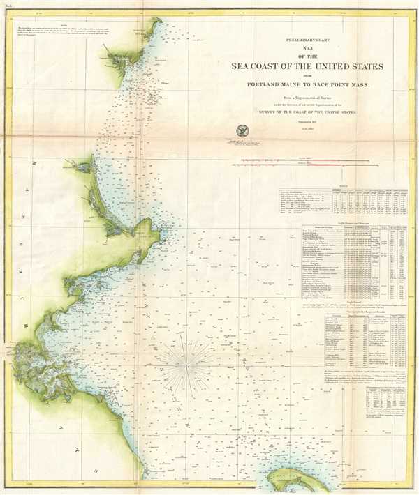
Preliminary Chart No. 3 of the Sea Coast of the United States from Portland Maine to Race Point Massachusetts.
1857 (dated) 25 x 21.5 in (63.5 x 54.61 cm) 1 : 200000
1857 (dated) 25 x 21.5 in (63.5 x 54.61 cm) 1 : 200000
Description
This is an 1857 U.S. Coast Survey map or nautical chart of a northern section of the east coast of the United States. The map depicts from just north of Portsmouth, Maine to Dorchester, Massachusetts and from the coast out into Massachusetts Bay and the Atlantic Ocean. The Boon Island Lighthouse is depicted off the coast of Maine. Several other coastal cities and landmarks are illustrated, including Newburyport, Cape Ann, Gloucester, Salem, and Boston. The northernmost reaches of Cape Cod are included along the bottom border and Provincetown and the Race Point Lighthouse are labeled. Depth soundings are recorded all along the coast, with the occasional island noted as well. Plum Sound and the Piscataqua, Merrimac, and Charles rivers are all depicted. Tables with information concerning tides, lighthouses and beacons, magnetic needle variations, and abbreviations used on the map are included along the left side.
This map was prepared for inclusion in the Report of the Superintendant of the U.S. Coast Survey, in 1857.
This map was prepared for inclusion in the Report of the Superintendant of the U.S. Coast Survey, in 1857.
CartographerS
The Office of the Coast Survey (1807 - present) founded in 1807 by President Thomas Jefferson and Secretary of Commerce Albert Gallatin, is the oldest scientific organization in the U.S. Federal Government. Jefferson created the "Survey of the Coast," as it was then called, in response to a need for accurate navigational charts of the new nation's coasts and harbors. The spirit of the Coast Survey was defined by its first two superintendents. The first superintendent of the Coast Survey was Swiss immigrant and West Point mathematics professor Ferdinand Hassler. Under the direction of Hassler, from 1816 to 1843, the ideological and scientific foundations for the Coast Survey were established. These included using the most advanced techniques and most sophisticated equipment as well as an unstinting attention to detail. Hassler devised a labor intensive triangulation system whereby the entire coast was divided into a series of enormous triangles. These were in turn subdivided into smaller triangulation units that were then individually surveyed. Employing this exacting technique on such a massive scale had never before been attempted. Consequently, Hassler and the Coast Survey under him developed a reputation for uncompromising dedication to the principles of accuracy and excellence. Unfortunately, despite being a masterful surveyor, Hassler was abrasive and politically unpopular, twice losing congressional funding for the Coast Survey. Nonetheless, Hassler led the Coast Survey until his death in 1843, at which time Alexander Dallas Bache, a great-grandson of Benjamin Franklin, took the helm. Bache was fully dedicated to the principles established by Hassler, but proved more politically astute and successfully lobbied Congress to liberally fund the endeavor. Under the leadership of A. D. Bache, the Coast Survey completed its most important work. Moreover, during his long tenure with the Coast Survey, from 1843 to 1865, Bache was a steadfast advocate of American science and navigation and in fact founded the American Academy of Sciences. Bache was succeeded by Benjamin Pierce who ran the Survey from 1867 to 1874. Pierce was in turn succeeded by Carlile Pollock Patterson who was Superintendent from 1874 to 1881. In 1878, under Patterson's superintendence, the U.S. Coast Survey was reorganized as the U.S. Coast and Geodetic Survey (C & GS) to accommodate topographic as well as nautical surveys. Today the Coast Survey is part of the National Oceanic and Atmospheric Administration or NOAA as the National Geodetic Survey. More by this mapmaker...
Alexander Dallas Bache (July 19, 1806 - February 17, 1867) was an American physicist, scientist and surveyor. Bache is best known in cartographic circles as the Superintendent of the U.S. Coast Survey from 1843 to 1865. Born in Philadelphia, Bache, a great grandson of the statesman and inventor Benjamin Franklin, had a varied career primarily focused on education. He toured Europe on behalf of Girard College and composed an important treatise on European Education. Later he served as president of Philadelphia's Central High School and was a professor of natural history and chemistry at the University of Pennsylvania. On the death of Ferdinand Rudolph Hassler, Bache was appointed Superintendent of the United States Coast Survey. Picking up where Hassler left off Bache presided over the Survey during its most prolific period and oversaw the mapping of most of the United States coastline. To this day his name appears on countless marine pilot books and U.S. Coast Survey nautical charts. For his work he was elected Associate Fellow of the American Academy of Arts and Sciences, a Fellow of the Royal Society of Edinburgh, and a Foreign Member of the Royal Society. Following the Civil War, Bache was elected a 3rd Class Companion of the Military Order of the Loyal Legion of the United States. He died at Newport, Rhode Island and was buried in the Congressional Cemetery in Washington, DC, where he is commemorated with a monument built by American architect Henry Hobson Richardson. Learn More...
Source
Bache, A. D., Report of the Superintendant of the U.S. Coast Survey, (Washington) 1857.
Condition
Very good. Wear along original fold lines. Backed on archival tissue for stability. Blank on verso. A pea sized spot to the cartouche with other related spots.