This item has been sold, but you can get on the Waitlist to be notified if another example becomes available, or purchase a digital scan.
1815 Thomson Map of Porto Rico and Hispaniola
PortoRicoHispaniola-thomson-1815$225.00

Title
Porto Rico and Virgin Isles. / Haiti, Hispaniola or St. Domingo.
1815 (dated) 21 x 24 in (53.34 x 60.96 cm) 1 : 700000
1815 (dated) 21 x 24 in (53.34 x 60.96 cm) 1 : 700000
Description
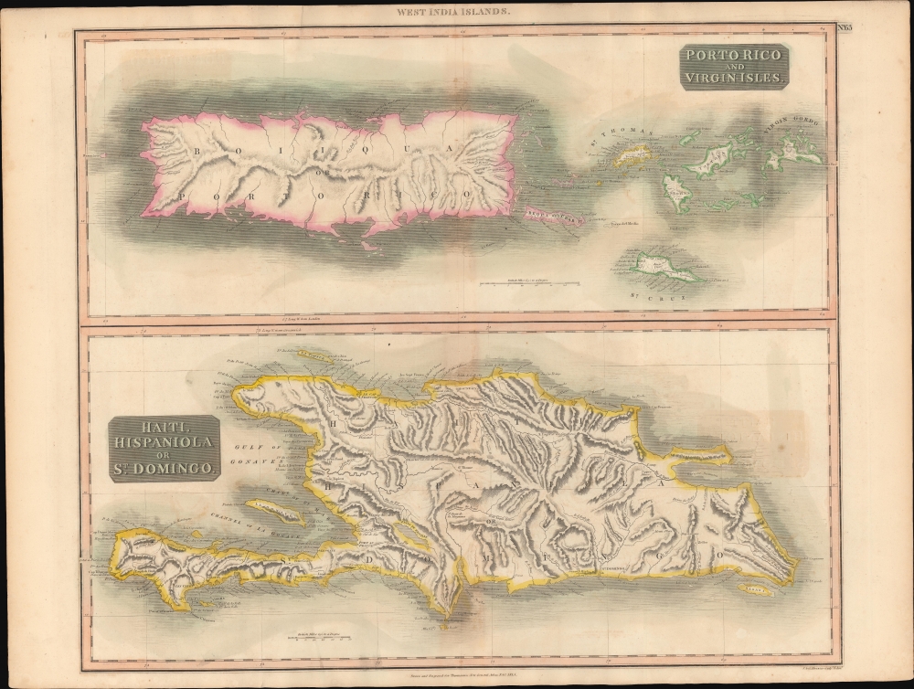
A beautiful large format 1815 John Thomson map of Porto Rico, the Virgin Islands, and Hispaniola (Haiti / Dominican Republic). When this map was issued, this was a region racked with internal strife and rebellion - mostly revolving around slavery.
Porto Rico at the time was still a Spanish colony under the old colonial system. Slavery remained legal and the primary export was sugar. Nearby St. Thomas and St. Croix were both Danish colonies, both of which had legalized slavery, but as this map went to press in 1817, St. Croix was in open rebellion - it is perhaps for this reason that the island is colored Green, to match the British Virgin Islands, possibly suggesting hope for a new colony.
Despite its placid monochromatic presentation here, Santo Domingo / Hispaniola, was divided between the Spanish colony of the Dominican Republic and Haiti. Haiti gained independence in 1804 when Toussaint L'Ouverture and later Jean-Jacques Dessalines led a successful slave revolt against France (which was then embroiled in the Napoleonic Wars), becoming the world's first independent black republic.
A Closer Look
Essentially two maps on one sheet. The upper map details Porto Rico, or as it was once known Boiiqua and extends westward to include the Virgin Islands, St. Thomas, and St. Croix (St. Cruz). The lower map focuses more narrowly on Hispaniola.Porto Rico at the time was still a Spanish colony under the old colonial system. Slavery remained legal and the primary export was sugar. Nearby St. Thomas and St. Croix were both Danish colonies, both of which had legalized slavery, but as this map went to press in 1817, St. Croix was in open rebellion - it is perhaps for this reason that the island is colored Green, to match the British Virgin Islands, possibly suggesting hope for a new colony.
Despite its placid monochromatic presentation here, Santo Domingo / Hispaniola, was divided between the Spanish colony of the Dominican Republic and Haiti. Haiti gained independence in 1804 when Toussaint L'Ouverture and later Jean-Jacques Dessalines led a successful slave revolt against France (which was then embroiled in the Napoleonic Wars), becoming the world's first independent black republic.
Publication History
This map was prepared and engraved in 1815 in Edinburgh by J. and G. Menzies for inclusion in the 1817 first edition of John Thomson's New General Atlas.CartographerS
John Thomson (1777 - c. 1841) was a Scottish cartographer, publisher, and bookbinder active in Edinburgh during the early part of the 19th century. Thomson apprenticed under Edinburgh bookbinder Robert Alison. After his apprenticeship, he briefly went into business with Abraham Thomson. Later, the two parted ways, John Thomson segueing into maps and Abraham Thomson taking over the bookbinding portion of the business. Thomson is generally one of the leading publishers in the Edinburgh school of cartography, which flourished from roughly 1800 to 1830. Thomson and his contemporaries (Pinkerton and Cary) redefined European cartography by abandoning typical 18th-century decorative elements such as elaborate title cartouches and fantastic beasts in favor of detail and accuracy. Thomson's principle works include Thomson's New General Atlas, published from 1814 to 1821, the New Classical and Historical Atlas of 1829, and his 1830 Atlas of Scotland. The Atlas of Scotland, a work of groundbreaking detail and dedication, would eventually bankrupt the Thomson firm in 1830, at which time their plates were sequestered by the court. The firm partially recovered in the subsequent year, allowing Thomson to reclaim his printing plates in 1831, but filed again for bankruptcy in 1835, at which time most of his printing plates were sold to A. K. Johnston and Company. There is some suggestion that he continued to work as a bookbinder until 1841. Today, Thomson maps are becoming increasingly rare as they are highly admired for their impressive size, vivid hand coloration, and superb detail. More by this mapmaker...
John Menzies (October 27, 1772 - October 16, 1857) was a Scottish engraver active in Edinburgh during the late 18th and early 19th centuries. Menzies mastered engraving as an apprentice to James Rymer. In 1811, he partnered with his younger brother, George Menzies, to found the engraving firm of J. and G. Menzies, which was active until about 1831. Later his son, also named John, joined the firm and they engraved jointly under the imprint of J. Menzies and Son. At its height, the Menzies firm employed three men and three apprentices. Menzies engraved maps for Thomas Brown and John Thomson, among others. After his death, his son, John Menzies II (1819 – 1891), continued the family business until about 1891. Learn More...
Baldwin and Cradock (fl. c. 1810 - 1860) were London based publishers working in the early to mid 19th century. They are best known for their publication of the Society for the Diffusion of Useful Knowledge's ground breaking subscription atlas. They also published John Thomson's magnificent New General Atlas from 1814 - c. 1820. In addition to their cartographic corpus, the firm had wide ranging publishing interests in many other areas, including books, broadsides, and an investment in Blackwoods Magazine. They had their offices at 47 Paternoster Row, London, England. This firm also published under the imprint Baldwin, Cradock, and Joy and Cradock and Joy. Learn More...
Source
Thomson, J., A New General Atlas, (Edinburgh: Baldwin, Cradock, Joy) 1817.
Condition
Good. Original centerfold exhibits some discoloration. Some offsetting.
References
Rusmey 1007.002. Catalogue of maps of Hispanic America, v. 1, p. 245.