1840 Perrot Comparative Chart of the Heights of the Monuments of the World
PrincipauxMonuments-perrot-1840$950.00

Title
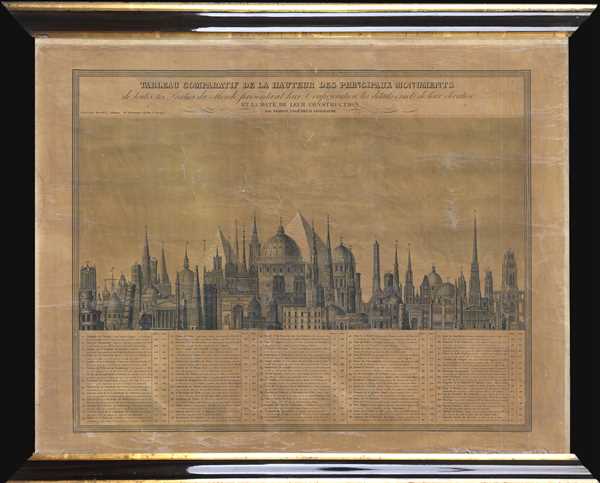
Tableau Comparatif de la Hauteur des Principaux Monuments de toutes les Parties du Monde, présentant leur Configuration, les details éxacts de leur élévation, et la Date de leur Construction.
1840 (undated) 17.25 x 23.25 in (43.815 x 59.055 cm)
1840 (undated) 17.25 x 23.25 in (43.815 x 59.055 cm)
Description
This is a separate issue c.1840 Aristide Michel Perrot comparative chart of the heights of the monuments of the world. The chart depicts 71 different numerically identified monuments located throughout the world, although the majority are in Europe, and the majority of those are located in France. A table, situated in the bottom quarter of the chart, bears the name, location, height (in both meters and feet), and a small note about each of the 71 monuments. The monuments represented include the Pyramids at Giza (numbers 1 and 4), numerous bell towers of churches and cathedrals throughout Europe, such as those at Vienna (3), Rouen (9), Chartres (10 and 13), Hamburg (12), and Reims (23), Westminster in London (28), Notre-Dame de Paris (33), and the Arc de Triomphe (49) to name only a few. Each of the monuments is depicted in profile, allowing for easy recognition of each of them.
This chart was composed by Arisitide Michel Perrot and published by Maison Basset c. 1840. This is a separate issue edition of this chart. Smaller versions of this chart were published in atlases, but this is the only separate issue (and larger) example we have located, making this a very rare find.
This chart was composed by Arisitide Michel Perrot and published by Maison Basset c. 1840. This is a separate issue edition of this chart. Smaller versions of this chart were published in atlases, but this is the only separate issue (and larger) example we have located, making this a very rare find.
CartographerS
Aristide Michel Perrot (1793 - 1879) was a French geographer, cartographer, and essayist active during the 19th century. Perrot specialized in miniature maps that appear in numerous French atlases. Perrot was also a prolific writer and his works include geographic lexicons and several essays. More by this mapmaker...
André Basset (Bassett; fl. 1768 - 1784) was a well-known French publisher and engraver active on the Rue St. Jacques, Paris, during the 18th and 19th centuries. His office was located at the corner of Rue Saint Jacques and of Mathurins, à l'enseigne de Sainte Geneviève. The firm is closely aligned with the Chéreau family of printers and engravers, with whom they were connected with multiple, often incestuous, marriages and remarriages. Basset was best known for the production of low-cost optical views of European cities and events. However, the firm also produced games, maps, and other prints. The firm was taken over by Paul-André Bassett (1759 - 1829) in 1784. Paul-André Bassett himself retired in 1819, but the business continued under various family members until 1865. Learn More...
Condition
Good. Mounted as a wall map. Varnished over. Varnish exhibits moderate degradation. Some whitening. Slightly shinier than map appears in image. Could be removed by professional restorer. Closed tear professionally repaired on verso. Blank on verso.
References
Rumsey 3771.006 OCLC 558062142.