
1935 Huber Arabic Pictorial Map of Rhodes, Greece

Rodi. Rhodes. Rhodos. RHODVS. ΡΟΔΟΣ. Rodi. 'رودس .רוד
Rare Rhodes Pictorial map - Arabic Edition.
$1,000.00
Choose a Collection:
- Digital Map Information
- Suitable for large format printing
- Full resolution TIFF file
- ICC color profile embedded
- Delivered instantly via download link
This Item
Enquire
Rare Rhodes Pictorial map - Arabic Edition.
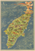
This is a 1935 Egon Huber pictorial map of Rhodes, then a colony of Mussolini's Italy, in an unusual edition with Arabic text on the verso. It reflects the spirit of Rhodes' pre-occupation period, before the onset of aggressive Italianization policies, when the beautiful island was celebrated for its cultural diversity. This map was issued in at least 7 languages, but this is the first time we’ve encountered an Arabic variant.A Closer Look
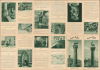
The Colossus of Rhodes (one of the Seven Wonders of the Ancient World) dominates the image, surrounded by a banner with the island's name in Italian, English, Turkish, Arabic, Ladino, Greek, and Latin. Cities, towns, and the island's picturesque countryside are beautifully illustrated. A knight carrying a shield bearing the symbol of the Knights Hospitaller (headquartered on Rhodes from 1310 to 1522) is illustrated slaying a dragon. Groups of Rhodians are illustrated dancing, picking grapes, hunting, weaving, and celebrating. The Rosa d'Oro, a now-defunct automobile race in Rhodes, is illustrated near the bottom of the island. A view of the city of Rhodes appears in the upper left. The white lines and background color lend a slightly eerie air to the illustration. The verso includes text in Arabic and images related to the island's history, main attractions, and practical information for travelers.Italian Rodi
Being located in a strategic waterway, Rhodes has seen empires come and go. When this map was produced, Mussolini was in power. The island was seized by Italy in the Italo-Turkish War (1912), in an arrangement meant to be temporary, but which became permanent when the Ottoman Empire collapsed after World War I (1914 - 1918). With the Treaty of Lausanne (1923), Italy formally annexed the Dodecanese Islands, transitioning from a temporary military occupation to a permanent colonial project. During the Interwar Period (1918 - 1939), Rhodes served as the administrative center of the Italian Aegean Islands (Isole Italiane dell'Egeo). The Italians oversaw a massive push for modernization and architectural transformation, seeking to turn Rhodes into a 'Pearl of the Mediterranean,' blending Venetian, Gothic, and Moorish styles with modern Fascist aesthetics. This era saw the restoration of the Hospitaller Palace of the Grand Master and the construction of sweeping public works, aimed at legitimizing Italian rule by framing it as a return to Roman or Crusader glory.The later Fascist period was defined by the governorship of the hardline Cesare Maria de Vecchi over the Isole Italiane dell'Egeo, beginning in December 1936. In contrast to his tolerant predecessors, who accepted the island's multicultural heritage, De Vecchi sought to aggressively Italianize the island by banning Greek, supporting Roman Catholicism and pressuring the Greek Orthodox Church, and instituting Antisemitic Laws. Rhodes was increasingly militarized as Mussolini sought to project power toward the Levant, transforming the island from an idyllic Mediterranean tourist destination into a strategic fortress. When Italy signed an armistice in September 1943, the Germans invaded Rhodes and held it until the end of the war against combined British-Italian attacks, after which the island's Jews were sent to concentration camps in Europe.
Egon Huber
We have been unable to unearth concrete information about this map's creator, Egon Huber. The overwhelming consensus among reference sources is that he was born in 1926 and arrived on Rhodes in 1931. He then became a successful potter and worked with ICARO/IKAROS pottery on Rhodes, where he eventually served as the technical director of the IKAROS factory. If that birth date is correct, that would mean that Huber was nine when he created this pictorial map of Rhodes, which raises more questions than it answers.Publication History and Census
This map was drawn by Egon Huber, printed by the firm Pizzi and Pizio, and published by the Italian State Tourist Department (ENIT) in 1935. There are multiple printings of this map, each with a different language on the verso. Across editions, there are slight but significant modifications (for example, above the small map on the verso, the English edition features a list of churches, whereas the Arabic edition features text on the variety of religions practiced on the island). Huber's map was also used for a French language poster issued the same year (Rumsey 8479.000). Regardless of edition, we note two cataloged examples of the map: one at Princeton University and one at the National Library of Israel, whose catalog notes that the verso of their example contains Hebrew (likely Ladino/Rashi) text. This map occasionally appears on the private market.Condition
Very good. Slight reinforcement along original fold lines.
References
Princeton University HMC01.6516. OCLC 907802589.