1866 Chandless Ribbon Map of the Purus River, Brazil and Peru
RiverPurus-chandless-1866$300.00

Title
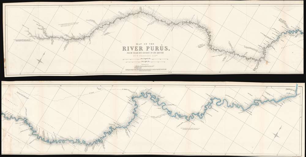
Map of the River Purûs, From Near its Source to its Mouth.
1866 (undated) 8 x 67.25 in (20.32 x 170.815 cm) 1 : 745000
1866 (undated) 8 x 67.25 in (20.32 x 170.815 cm) 1 : 745000
Description
This is landmark 1866 William Chandless map of the Purûs River in Brazil and Peri is he first accurate map of the river's 1,866-mile course. Chandless took measurements throughout his expedition, covering both the ascent and the descent of the river. He identifies tributaries, islands, and Indian villages, and includes a handful of comments concerning the river's depth and width. In the appendix to his article on the expedition, Chandless addresses the creation of the map:
This has been made from bearings and distances taken throughout the whole river, and from observations with sextant and artificial horizon (mercurial). Observations of latitude were taken at 79 points, and time observations for longitude by chronometer at about three-fourths of them. So far as was possible, time observations were repeated at the principal points on the down voyage, so as to be dependent on chronometer for a few days only.Even today the Purûs River basis is considered on of the most remote, biodiverse, and inaccessible parts of the Amazon Rainforest. In 2008, a previously unknown pre-Columbian civilization was discovered in the upper region of the river close to the Bolivian border. After much of the forest in the region was cleared for agricultural use, satellite pictures revealed the remains of large geometric earthworks.
Publication History and Census
This map was created by William Chandless, engraved by Edward Weller, and published by John Murray in the 1866 edition of The Journal of the Royal Geographical Society. We note a single example cataloged in OCLC and as part of the collections at the Bibliothèque nationale de France.CartographerS
William Chandless (November 7, 1829 - May 5, 1896) was an English explorer. Chandless graduated from Trinity College, Cambridge, with high honors, and then studied law for two years before realizing that the law wasn't for him. In 1854, Chandless was in the United States along the Missouri River watching Mormons travel west to Utah by covered wagon. Since he was barred from joining them, Chandless hired a 'teamster' at $25 a month. He chronicled this journey in a landmark travel narrative A visit to Salt Lake, and a Residence in the Mormon Settlements of Utah. After leaving Salt Lake, he continued west to Los Angeles and San Francisco. From San Francisco he traveled to Acapulco. He then crossed Mexico and returned to England. Chandless first left for Brazil in 1858, but did not stay long as he was in Argentina the following year during the great earthquakes in Mendoza. From there he crossed the Andes to Chile, and from Valparaiso he continued on to Peru and Ecuador. He traveled from Ecuador to Colombia in 1861, and was detained several times by different factions vying for control of Colombia. Chandless took up residence in Manaus, Brazil, soon afterward, and lived there for years. He based numerous explorations of the southern tributaries of the Amazon River from Manaus, including an ascension of the 1,866-mile course of the Purus River, for which the Royal Geographical Society awarded him its Patron's Medal. Chandless contacted a number of indigenous tribes and explored several of the Amazon River's southern tributaries. In 1867, Chandless recorded a few words of Arawá, an extinct language for which the Arauan language group is named. Without this list compiled by Chandless, all record of this language would have been lost. In 1868, Chandless accomplished a thorough survey of the Juruá River, ascending its 1,133-mile course. Over the course of his years in the Amazon, Chandless surveyed over 5,000 miles of main streams and branches of the Amazon River. More by this mapmaker...
John Murray I (1737 - 1793) founded the British publishing firm John Murray (1768 - present) in London. Born in Edinburgh, Murray served as an officer in the Royal Marines and built a list of authors that included Isaac D’Israeli and published the English Review. Murray the elder also was one of the founding sponsors of the London evening newspaper The Star in 1788. John Murray II (November 27 1778 - June 27, 1843) continued the family publishing business and developed it into one of the most important and influential publishing houses in Britain. The list of authors published by the firm grew to include Jane Austen, Sir Walter Scott, Washington Irving, George Crabbe, and Lord Byron under his tenure. Murray II also moved the business to 50 Albermarle Street in Mayfair, which became famous for Murray’s tradition of ‘four o’clock friends’, which was afternoon tea with his writers. John Murray III (1808 - 1892) continued to grow the business, and the firm published the first English translation of Goethe’s Theory of Colours, David Livingstone’s Missionary Travels and Charles Darwin’s Origin of Species during his tenure. Murray also published Herman Melville’s first two books. The firm began publishing Murray Handbooks in 1836, an ancestor of all modern travel guides. Sir John Murray IV (1851 - 1928) was publisher to Queen Victoria. Three successive Murray’s after Murray IV led the business until it was purchased by Hodder Headline in 2002, which was acquired by the French conglomerate Lagardère Group in 2004. Today, Murray is an imprint of Lagardère under the imprint Hachette UK. Learn More...
Edward Weller (July 1, 1819 - 1884) was a cartographer and engraver based in London. Weller was a nephew of another well-known map publisher Sidney Hall (1788 - 1831), who gave him 50 Pounds to pay his apprenticeship fees. He engraved for many prominent mapmakers and was active enough in the community to be recommended for membership to the Royal Geographical Society in 1851 on the recommendation of John Arrowsmith, among others. He eventually inherited the Sidney Hall map business which led him to follow Arrowsmith as the unofficial geographer to the Royal Geographical Society. Weller was among the first map printers in London to embrace lithography. His best known work appears in Cassell's Weekly Dispatch Atlas, published in monthly segments for subscribers of the 'Weekly Dispatch' newspaper. This collection of maps eventually grew to include much of the known world. Published in various editions from 1855 through the early 1880s. Weller died in May of 1884, leaving behind a successful business and an unhappy widow. His son, Francis Sidney Weller (1849 - 1910), followed in his father's footsteps and continued the family map business. The atlas Mackenzie's Comprehensive Gazetteer of England and Wales was published in 1894 and bore F. S. Weller's signature on the maps. Learn More...
Royal Geographical Society (fl. 1830 - present) is a British Society established in 1830 to promote geographical science and exploration. Originally titled the "Geographical Society of London", the RGS received its royal charter from Queen Victoria in 1859 shortly after absorbing several similar but more regional societies including the African Association, the Raleigh Club and the Palestine Association. The RGS sponsored many of the most important and exciting voyages of exploration ever undertaken, including the exploration of Charles Darwin, David Livingstone, Robert Falcon Scott, Richard F. Burton, John Speke, George Hayward, H. M Stanley, Ernest Shackleton and Sir Edmond Hillary. Today, the RGS remains a leading global sponsor of geographical and scientific studies. The Society is based in Lowther Lodge, South Kensington, London. Learn More...
Source
Chandless, W., 'Ascent of the River Purus', The Journal of the Royal Geographical Society Vol. 36 (Murray: London) 1866.
Condition
Very good. Exhibits light wear and toning along original fold lines. Bottom border cut very close, up to border in places. Blank on verso.
References
OCLC 495077706.