Digital Image: 1888 Ensign Forestry Map of the Rocky Mountains
RockyMountainRegion-ensign-1888_d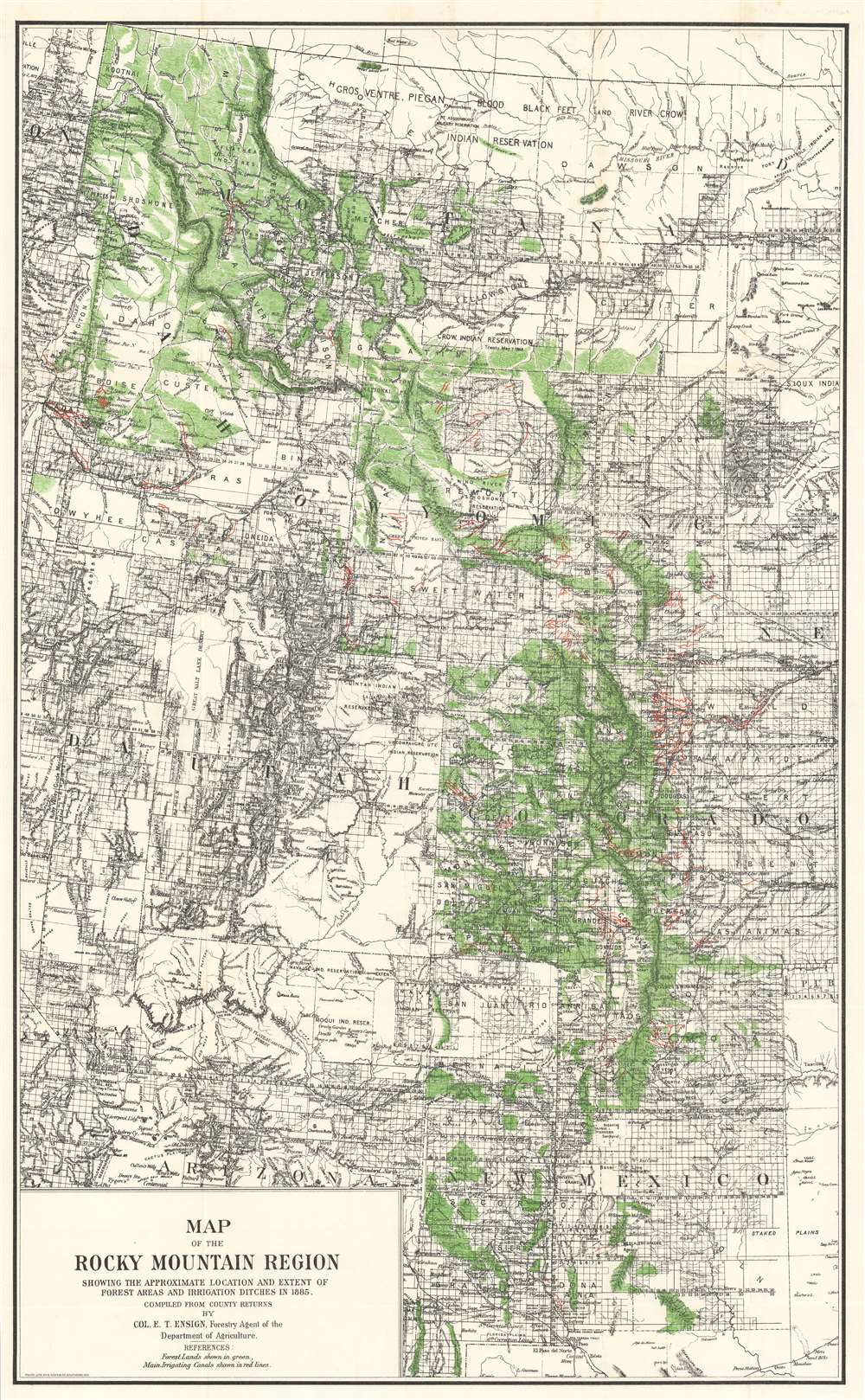

Title
Map of the Rocky Mountain Region Showing the Approximate Location and Extent of Forest Areas and Irrigation Ditches in 1885.
1888 (undated) 31.5 x 19.25 in (80.01 x 48.895 cm)
1888 (undated) 31.5 x 19.25 in (80.01 x 48.895 cm)
Description
FOR THE ORIGINAL ANTIQUE MAP, WITH HISTORICAL ANALYSIS, CLICK HERE.
Digital Map Information
Geographicus maintains an archive of high-resolution rare map scans. We scan our maps at 300 DPI or higher, with newer images being 600 DPI, (either TIFF or JPEG, depending on when the scan was done) which is most cases in suitable for enlargement and printing.
Delivery
Once you purchase our digital scan service, you will receive a download link via email - usually within seconds. Digital orders are delivered as ZIP files, an industry standard file compression protocol that any computer should be able to unpack. Some of our files are very large, and can take some time to download. Most files are saved into your computer's 'Downloads' folder. All delivery is electronic. No physical product is shipped.
Credit and Scope of Use
You can use your digial image any way you want! Our digital images are unrestricted by copyright and can be used, modified, and published freely. The textual description that accompanies the original antique map is not included in the sale of digital images and remains protected by copyright. That said, we put significant care and effort into scanning and editing these maps, and we’d appreciate a credit when possible. Should you wish to credit us, please use the following credit line:
Courtesy of Geographicus Rare Antique Maps (https://www.geographicus.com).
How Large Can I Print?
In general, at 300 DPI, you should at least be able to double the size of the actual image, more so with our 600 DPI images. So, if the original was 10 x 12 inches, you can print at 20 x 24 inches, without quality loss. If your display requirements can accommodate some loss in image quality, you can make it even larger. That being said, no quality of scan will allow you to blow up at 10 x 12 inch map to wall size without significant quality loss. For more information, it is best consult a printer or reprographics specialist.
Refunds
If the high resolution image you ordered is unavailable, we will fully refund your purchase. Otherwise, digital images scans are a service, not a tangible product, and cannot be returned or refunded once the download link is used.
Cartographer S
Edgar Tarbell Ensign (September 9, 1839 - February 15, 1918) was an American banker, lawyer, forester, and public servant. Born in Moriah, New York, Tarbell attended the local district school and village academy before entering a boy's private school in Sarasota Springs, New York. He moved to Des Moines, Iowa in 1856, where he found a job in the banking house of A.J. Stearns and Company, and his parents joined him in Des Moines three years later. While still living in Iowa, Ensign was appointed deputy state treasurer in 1858. After the outbreak of the American Civil War, Ensign volunteered for the Second Iowa Volunteer Infantry and enlisted on May 4, 1861, when he was commissioned as a second lieutenant. Ensign served in the Union Army until the end of the war, eventually reaching the rank of brevet colonel. He was wounded only once during his service at the Battle of Fort Donelson, Tennessee. After the war, Ensign attended the Iowa Law School, from which he received his LL. B. and A. B. Degrees, and also received an LL. B. Degree from Columbian College, which would eventually be merged with George Washington University. He was admitted to the Iowa bar in 1868 and opened a law practice in Des Moines. He was appointed district attorney that same year. Ensign lived in Des Moines until 1874, when he moved west to Colorado Springs. Once there, he opened another law office and soon after his arrival was appointed commissioner of the United States circuit court. He served as the Colorado State Forest Commissioner from 1883 until 1889. He spent a further two years as a special agent of the United States General Land Office working on setting up forest reserves, which would eventually become known as national forests. He helped organize the Assurance Savings and Loan Association in 1895, and served as its president until September 1917. He also tried his hand at banking, as he was one of the organizers of the First National Bank of Colorado City and the National Bank Building Company. He also served a three year term as president of First National. He married Lilla Butin on October 17, 1872 in Des Moines, After his death, the Memoriam of the Military Order of the Loyal Legion, of which he was a member, stated, 'The life career of Colonel Ensign as a gentleman, a soldier, and a friend is worthy of emulation by all.' Ensign died on February 15, 1918 in Colorado Springs. More by this mapmaker...
August Hoen and Company (fl. c. 1840 - 1981) was a Baltimore based engraving and lithography firm active in the middle part of the 19th century. A. Hoen and Co. was originally founded by Edward Weber under the name 'E. Weber and Company.' Weber died in the early 1850s and his company was taken over by German immigrant August Hoen (18?? - 1886) and his brothers, Henry and Ernest Hoen. As general interest lithographers, the Hoen firm's corpus includes posters, cigar boxes, sheet music covers, and posters as well as maps. They are best known for their pioneering multi-color lithographic techniques. After the death of August Hoen, the business passed on to his son, Albert Hoen. Another son, Earnest A. Hoen, moved to Richmond, Virginia and opened a branch of the firm there where he was granted a charter to produce Civil War era Confederate Currency. Their contributions to the cartographic field are generally in association with engraving and printing work done for Jacob Monk and the U.S. Geological Survey. The Hoen family maintained an active interest in the firm for the next 100 years or so until it finally filed for bankruptcy in 1981. Learn More...
References
OCLC 1084941805.