This item has been sold, but you can get on the Waitlist to be notified if another example becomes available, or purchase a digital scan.
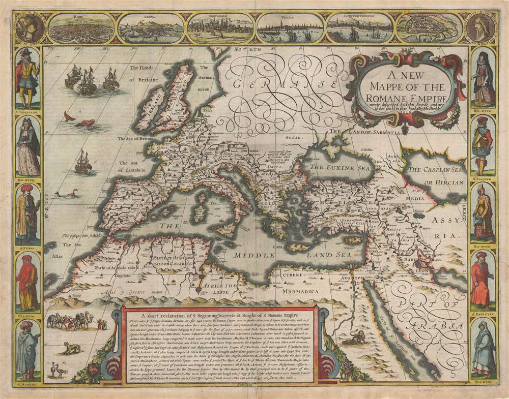
1646 John Speed Map of the Roman Empire
RomanEmpire-speed-1626$750.00

Title
A New Mappe of the Romane Empire newly described by John Speede and are to bee sould in pops head alley by G. Humble 1626.
1626 (dated) 15.5 x 20 in (39.37 x 50.8 cm) 1 : 15000000
1626 (dated) 15.5 x 20 in (39.37 x 50.8 cm) 1 : 15000000
Description
This is an attractive example of John Speed's 1626 carte à figures of the Roman Empire at its height. The map uses contemporary geographical knowledge as a framework, applying place names appropriate to the geographical knowledge of the Roman era. The map is bordered with figures and a set of city views, suiting the early seventeenth century fashion.
On the other hand, the upper left and right corners include more topical fare. To the right is a dedicatory medallion depicting and praising Romulus, the legendary founder of Rome: 'To Romulus ye Builder of ye Eternal City'. To the upper left is a medallion featuring the profile of wing-helmeted Roma: avatar of Rome and more broadly, the Roman state. Her portrait bears a message of dread: 'Rome thy name is fatall in ruling countries.' These are, again, drawn from the Latin text of similar medallions embellishing Ortelius' map. The text for Roma comes from Roman poet Tibullus' 19 BCE elegy. Speed's translation is execrable - perhaps deliberately. A better translation of 'Roma, tuum nomen terris fatale regendis' might be 'Rome, the name predestined to rule the world'.
'Frogs Around A Pond'
Plato's phrase from Phaedo described the ancient world's relationship to the Mediterranean - a relationship that remained unchanged under the Roman Empire. This is reflected in Speed's map. Settlements and place names hew close to the seas, particularly 'The Middle Land Sea' as he terms the Mediterranean. The map overall is derived closely from Abraham Ortelius' map of the Roman Empire historical atlas, Parergon. The historical text box filling north Africa, the place names, and the notations on the map are translated from Ortelius' Latin text. The decorative features, however, are unique, and reflect the skills of the Dutch engravers Speed contracted to execute his atlas: witness the lions in Egypt and ostriches, a cheetah, and a caravan of camels in west Africa. In the Atlantic, sea monsters prowl about, perhaps looking for morsels left over from the naval battle depicted.Incongruously Contemporary
The figures - depicting men from Italy, Egypt, Morocco, Turkey, and Spain across from their respective wives - wear garb reflective of the 16th century at the earliest. Their inclusion is fascinating and attractive, but make clear that neither Speed nor his engravers were familiar with Roman-era fashion. Likewise, the fine views of Rome, Genoa, Jerusalem, Venice, Constantinople, and Alexandria are more reflective of the situation of these cities in the 17th century, rather than in antiquity. It is likely that these were included more for their decorative qualities than edification.On the other hand, the upper left and right corners include more topical fare. To the right is a dedicatory medallion depicting and praising Romulus, the legendary founder of Rome: 'To Romulus ye Builder of ye Eternal City'. To the upper left is a medallion featuring the profile of wing-helmeted Roma: avatar of Rome and more broadly, the Roman state. Her portrait bears a message of dread: 'Rome thy name is fatall in ruling countries.' These are, again, drawn from the Latin text of similar medallions embellishing Ortelius' map. The text for Roma comes from Roman poet Tibullus' 19 BCE elegy. Speed's translation is execrable - perhaps deliberately. A better translation of 'Roma, tuum nomen terris fatale regendis' might be 'Rome, the name predestined to rule the world'.
Publication History and Census
This map was engraved for inclusion in John Speed's 1627 Prospect of the Most Famous Parts of the World , possibly by Abraham Goos, although the map lacks an engravers' imprint. It was included in all posthumously-published editions of the Speed atlas. This example bears the imprint of publisher George Humble, and corresponds typographically to the 1646 edition of the atlas published by Humble's son William. The separate map is cataloged in only four institutions in OCLC.CartographerS
John Speed (1542 - 1629) was an important English historian and cartographer active in the early 17th century. Speed was born in Fardon, Cheshire and apprenticed under his father as a tailor. Though his heart was never in tailoring, Speed dedicated himself to this profession until he was about 50 years old. During all the time, Speed dedicated his spare time to research as amateur historian and mapmaker - even preparing several maps for Queen Elizabeth. In London, Speed's interest in history lead him to join the Society of Antiquaries. Eventually he befriended the wealthy Sir Fulke Greville, who sponsored his researches and eventually freed him from the haberdashery profession. Working with William Camden, Speed eventually published his 1611 Historie of Great Britaine. Though this history itself was amateurish and of minimal importance, Speed's inclusion of numerous maps of British Cities and town was seminal. In many cases these plans were the first maps ever issued of their respective subjects. Later, turning his attention more fully to Geography, Speed published the magnificent atlas Theatre of the Empire of Great Britaine and, just prior to his death, the 1627 A Prospect of the Most Famous Parts of the World. These were the first British world atlases and have a landmark position in the history of cartography. These atlases continued to be published well after Speed's death. More by this mapmaker...
George Humble (1572 - 1640) was an English printseller and publisher; he is best known as the publisher for John Speed's 'The theatre of the empire of Great Britaine,' the first published atlas of the British Isles, and Speed's 'A prospect of the most famous parts of the World,' the first English world atlas. George was born in London the son of bookseller Thomas Humble; he would join a partnership with his uncle John Sudbury; in 1608 he received a twenty-one year privilege to publish Speed's work. With his death in 1640 he was succeeded in the business by his son, William Humble (1611 - 1686.) As a trader in books, Humble was a longtime member of the Leathersellers Company, and would serve as master of the Company in 1628 and 29. In addition to bequests to his sons, he provided for Oxford and Cambridge scholarships, and left money for Leathersellers' charitable activities. Learn More...
Abraham Ortelius (April 14, 1527 - June 28, 1598) also known as Ortels, was a cartographer, geographer, and cosmographer of Brabant, active in Antwerp. He was the creator of the first modern atlas, Theatrum Orbis Terrarum and is a seminal figure in the history of cartography. Along with Gerard Mercator and Gemma Frisius, he was a founder of the Netherlandish school of cartography. His connections with Spain - culminating in his 1575 appointment as Royal Cartographer to King Phillip II of Spain - gave him unmatched access to Spanish geographical knowledge during a crucial period of the Age of Discovery. Ortelius was born in 1527 in Antwerp. In 1547 he entered the Antwerp Guild of Saint Luke as an illuminator of maps. He began trading in books, prints, and maps, traveling regularly to the Frankfurt book and print fair, where in 1554 he met Mercator. He accompanied Mercator on journeys throughout France in 1560 and it was at this time, under Mercator's influence, that he appears to have chosen his career as a scientific geographer. His first published geographic work appeared in 1564, an eight-sheet cordiform world map. A handful of other maps preceded the 1570 publication of the first edition of the Theatrum Orbis Terrarum, which would prove to be his life work. Appearing with but 53 maps in its first edition, Ortelius' work expanded with new maps added regularly. By 1592, it had 134 maps. Many of Ortelius' maps remained the standard for nearly a century. He traveled extensively, but his genius was as a compiler, locating the best informed maps on which to base his own. His contacts throughout Europe and extending even (via the Portuguese) to the Far East were formidable. Moreover, many of his maps were based on his own scholarship, particularly his historical works. His theories of geography were particularly ahead of his time with respect to the notion of continental drift, the possibility of which he mused on as early as 1596, and which would be proven correct centuries later.
In a sense his greatest achievement was his successful navigation of the religious and political violence endemic to his city throughout his adult life: The Dutch Revolt, or Eighty Years' War (1568 - 1648), fully embroiled Antwerp. Although outwardly and officially recognized as Catholic (Arias Montanus vouched for Ortelius' Catholic orthodoxy prior to his appointment as Royal Geographer), Ortelius was able to separate himself from the religious furor which characterized the war in the low countries. Ortelius showed a glimpse of himself in a letter to a friend, regarding humanist Justus Lipsius: 'I do not know whether he is an adherent of the Pope or a Calvinist, but if he has ears to hear, he will neither be one nor the other, for sins are committed on both sides'. Ortelius' own explorations of Biblical history in his maps, and the Christogram contained in his own motto, suggest him to be a religious man, but his abjuration of political religious authorities mark him as an individualist. His tombstone at St Michael's Præmonstratensian Abbey in Antwerp bears the inscription, Quietis cultor sine lite, uxore, prole. ('served quietly, without accusation, wife, and offspring.') Learn More...
Source
Speed, J., Prospect of the Most Famous Parts of the World, (London: Humble) 1646.
Condition
Very good. Few mended splits just entering printed area with virtually no loss. Reinforced at margins and centerfold. Fine hand color.
References
OCLC 494728963. Rumsey 12058.181.