1822 Butler Map of Russia
Russia-butler-1822$100.00

Title
Russia.
1822 (dated) 10 x 8 in (25.4 x 20.32 cm)
1822 (dated) 10 x 8 in (25.4 x 20.32 cm)
Description
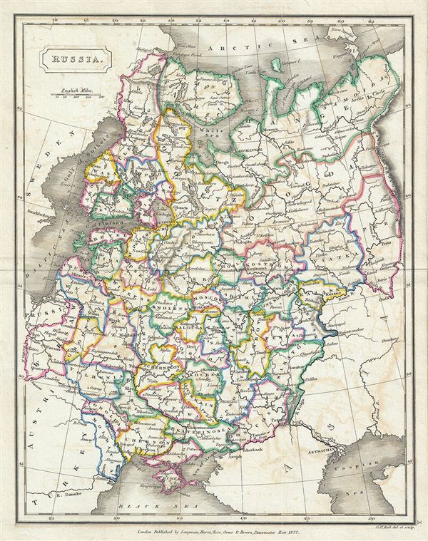
This is a fine example of Samuel Butler's 1822 map of Russia. It covers the european part of Russia from Lapland to the Caspian Sea and from the Baltic Sea to the Ural Mountains. In 1825, shortly after this map was drawn, Russian army officers, called the Decembrists, protested against Nicholas I's ascension to the throne. The Decembrists (so named because their revolt started in December), favored Nicholas I's brother, Constantine, who seemed amenable to a British style constitutional monarchy. When Constantine abdicated the throne in 1825, the Decembrists refused to accept the more autocratic rule of Nicholas I. Had Constantine not abdicated and the Decembrists been successful, the bloody Bolshevik Revolution may never have occurred. The map is somewhat detailed with regional boundaries outlined in color. Various towns, cities, rivers, and several other topographical features are noted with relief shown by hachure. This map was engraved by Sidney Hall and published by Longman, Hurst, Rees, Orme & Brown for issue as plate no. X in the 1822 edition of Samuel Butler's An Atlas of Modern Geography.
CartographerS
Samuel Butler (January 30, 1774 - December 4, 1839) was a British cleric, historian, and schoolmaster active in the late 18th and early 19th centuries. Butler is best known as a classical scholar, in which field he received numerous awards for meritorious achievement. Around 1798 he was assigned the post of headmaster at the prestigious Shrewsbury School. Having attained a Doctorate of Divinity in 1811, Butler became a clergyman in Kenilworth. He later became the Archdeacon of Derby and in 1836 the Bishop of Lichfield. Even as a clergyman Butler retained an interest in education and published several classical and modern geographies most of which went through many editions and were popular in schools across England. More by this mapmaker...
Sidney Hall (1788 - 1831) was an English engraver and map publisher active in London during the late 18th and early 19th centuries. His earliest imprints, dating to about 1814, suggest a partnership with Michael Thomson, another prominent English map engraver. Hall engraved for most of the prominent London map publishers of his day, including Aaron Arrowsmith, William Faden, William Harwood, and John Thomson, among others. Hall is credited as being one of the earliest adopters of steel plate engraving, a technique that allowed for finer detail and larger print runs due to the exceptional hardness of the medium. Upon his early death - he was only in his 40s - Hall's business was inherited by his wife, Selina Hall, who continued to publish under the imprint, "S. Hall", presumably for continuity. The business eventually passed to Sidney and Selina's nephew Edward Weller, who became extremely prominent in his own right. Learn More...
Longman (fl. c. 1720 - present) is a long lived and venerable British publishing firm initially founded 1720s by Thomas Longman (1699 - 1755). Longman was born in Bristol and in 1716 was apprenticed to John Osborn, a London printer and bookseller. Completing his apprenticeship, Longman requested and was granted the hand of Osborn's daughter. Shortly afterwards Longman acquired the stock of Robinson Crusoe publisher William Taylor and, along with Osborn, established a printing office on Paternoster Row. The two published numerous works including Samuel Johnson's Dictionary. Around the same time that Osborn retired Thomas Longman's nephew, another Thomas Longman (1730 - 1797), joined the firm which was subsequently renamed T. and T. Longman. On the death of the original Thomas Longman, the nephew took over the firm and eventually passed it on to his son, Thomas Norton Longman (1771 - 1842). Thomas Norton seemed to have had a passion for partnering and over the years added Owen Rees (1730 - 1797), Thomas Brown (c. 1777 - 1869), and three more mysterious partners, Hurst, Orme and Green, to the corporation's partner list. For many years the firm published as Longman, Hurst, Rees, Orme, Brown & Green. Thomas Norton eventually passed the firm to his own sons, Thomas and William, who during their tenure bought out most of the minor partners, renaming the firm Longmans, Green & Co. Later, Thomas Longman's son took control of the firm in full naming it just Longman. During World War II most of their plates and stock were destroyed but the company nonetheless survived and went public in 1948. Longman was eventually acquired by the media conglomerate Pearson and continues to publish as Pearson Longman. Learn More...
Source
Butler, S., An Atlas of Modern Geography, (London: Longman) 1822.
Condition
Very good. Minor overall toning. Some offsetting. Blank on verso. Minor wear over original centerfold.