1811 Carey / Barker Map of the Russian Empire
Russia-carey-1811$350.00

Title
Russian Empire, in Europe and Asia.
1811 (undated) 12 x 16 in (30.48 x 40.64 cm) 1 : 21000000
1811 (undated) 12 x 16 in (30.48 x 40.64 cm) 1 : 21000000
Description
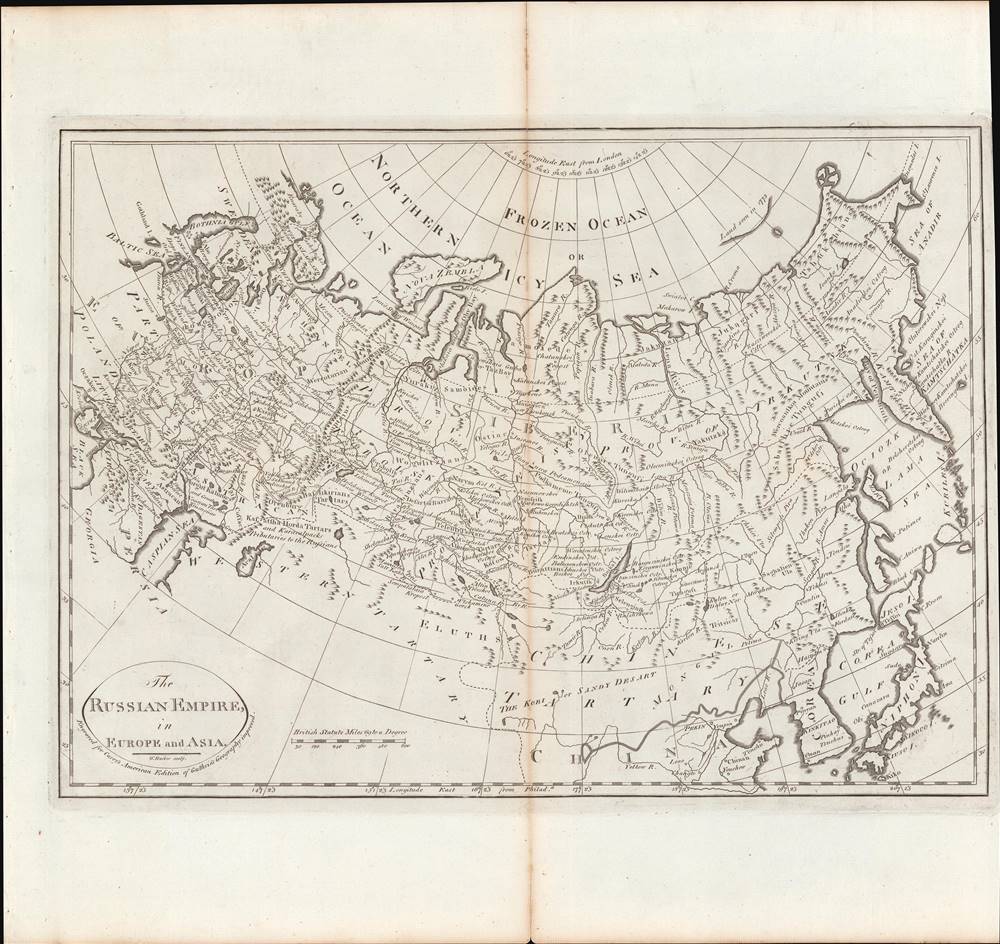
This is a rare c. 1811 map of the Russian Empire from Carey's General Atlas, the first atlas published in the new American Republic. It shows the Russian Empire after two and a half centuries of territorial expansion beginning with Ivan IV (the 'Terrible') through Catherine the Great.
The Russian presence across the vastness of Siberia was generally very light, confined to fortresses, trading posts, and remote churches. Still, exploration of these regions continued, including forays into the Arctic. The islands noted here as having been seen in 1773 are the Anzhu Islands, part of the New Siberian Islands (Novosibirskiye Ostrova). More specifically, it is Kotelny Island, spotted by the Russian merchant and hunter Ivan Lyakhov (Иван Ляхов). Around the time of this map's publication, in 1809 – 1811, a proper cartographic expedition consisting of Yakov Sannikov (Яков Санников) and the Swedish-born Matvei Gedenschtrom revisited Kotelny and surrounding islands, mapping them for the first time. Sannikov noticed lands even further to the north but was unable to explore them, a feat that would not be accomplished until the 1880s and 1890s by Eduard von Toll.
This map is especially attentive to the many Turkic and Mongol peoples that fell under the heading of 'Tatars,' residing between Crimea and the Pacific, who had formerly been ruled by the Mongol Empire and its successor states, or in some cases by the Ottomans. It also notes groups on the borders of the empire, some of whom were in a tributary relationship with the Tsar (such as the Karakalpaks). Russia would not move into 'Western Tartary' until later in the 19th century, starting with a disastrous attack on Khiva in 1839 – 1840, as part of a worldwide imperial competition with Britain. The people here called Eluths on the edge of 'Chinese Tartary' refers to the Dzungars, a powerful group of Oirat Outer Mongols who refused to accept Qing suzerainty in the 17th century and built a khanate covering much of what is now western Mongolia and Xinjiang, as well as portions of Central Asia. In a series of wars stretching over decades, the Dzungars were eventually defeated by the Qing in a brutal campaign that saw much of the Dzungar population exterminated on the orders of the Qianlong Emperor, in what some historians have deemed a genocide. The Dzungars occasionally sought Russian aid against their rivals and after the Qing conquest, some 20 percent of the Dzungar population fled into the Russian Empire or to lands of Kazakh tribes.
It is worth noting that the map was published the year before Napoleon's disastrous invasion of Russia. In the preceding decades, Catherine the Great had already made Russia into a major European power, and the defeat of Napoleon elevated Russia to superpower status, able to dictate much of the postwar settlement in Central and Eastern Europe.
Displaying Russia's Growing Empire
This map reflects Russia's growing interest and presence in Eastern Europe, the Caucasus, Siberia, and Central Asia. Russia's territory had expanded tremendously in the 16th – 18th centuries and was growing quickly even as Carey published the first edition of his atlas in 1795. For instance, here the empire ends at the Dnieper River in the west, but the Second Partition of Poland in 1793 extended the borders of the Russian Empire well into Right-bank Ukraine and Byelorussia. Two years later, Poland was partitioned once again and completely, providing Russia another significant piece of territory. Similarly, the map does not include Russian America, which was not claimed by Russia until 1799, and other territorial additions of Finland, Bessarabia (Moldova), and much of the Caucasus that occurred in the early 19th century.The Russian presence across the vastness of Siberia was generally very light, confined to fortresses, trading posts, and remote churches. Still, exploration of these regions continued, including forays into the Arctic. The islands noted here as having been seen in 1773 are the Anzhu Islands, part of the New Siberian Islands (Novosibirskiye Ostrova). More specifically, it is Kotelny Island, spotted by the Russian merchant and hunter Ivan Lyakhov (Иван Ляхов). Around the time of this map's publication, in 1809 – 1811, a proper cartographic expedition consisting of Yakov Sannikov (Яков Санников) and the Swedish-born Matvei Gedenschtrom revisited Kotelny and surrounding islands, mapping them for the first time. Sannikov noticed lands even further to the north but was unable to explore them, a feat that would not be accomplished until the 1880s and 1890s by Eduard von Toll.
This map is especially attentive to the many Turkic and Mongol peoples that fell under the heading of 'Tatars,' residing between Crimea and the Pacific, who had formerly been ruled by the Mongol Empire and its successor states, or in some cases by the Ottomans. It also notes groups on the borders of the empire, some of whom were in a tributary relationship with the Tsar (such as the Karakalpaks). Russia would not move into 'Western Tartary' until later in the 19th century, starting with a disastrous attack on Khiva in 1839 – 1840, as part of a worldwide imperial competition with Britain. The people here called Eluths on the edge of 'Chinese Tartary' refers to the Dzungars, a powerful group of Oirat Outer Mongols who refused to accept Qing suzerainty in the 17th century and built a khanate covering much of what is now western Mongolia and Xinjiang, as well as portions of Central Asia. In a series of wars stretching over decades, the Dzungars were eventually defeated by the Qing in a brutal campaign that saw much of the Dzungar population exterminated on the orders of the Qianlong Emperor, in what some historians have deemed a genocide. The Dzungars occasionally sought Russian aid against their rivals and after the Qing conquest, some 20 percent of the Dzungar population fled into the Russian Empire or to lands of Kazakh tribes.
It is worth noting that the map was published the year before Napoleon's disastrous invasion of Russia. In the preceding decades, Catherine the Great had already made Russia into a major European power, and the defeat of Napoleon elevated Russia to superpower status, able to dictate much of the postwar settlement in Central and Eastern Europe.
Publication History and Census
This map was engraved by William Barker and published by Matthew Carey in Philadelphia. It is likely from an 1811 edition of Carey's General Atlas (sometimes subtitled American Edition of Guthrie's Geography improved), multiple editions of which were printed between 1795 and 1818. It appears to be identical to the edition included in the David Rumsey Map Collection dated to 1811, the last edition of Carey's Atlas that used maps from the 1795 edition essentially unchanged, before Carey made a major overhaul of the maps for an 1814 edition. The prevalence of the map is difficult to determine since the map is not always cataloged with the year recorded, but both the individual map and the entire atlas are held by a handful of universities and research institutions in the United States.CartographerS
Matthew Carey (January 28, 1760 - September 16, 1839) was a Dublin born publisher who established himself in Philadelphia in the late 18th and early 19th century. A young man of socially progressive views, Carey's first known publication, produced when he was but 17 years old, was a pamphlet criticizing dueling. Another pamphlet, issued in the same year, attacked the Irish penal code. Shortly afterwards, in 1779, legal issues, possibly arising from his liberal political activism, forced Carey to flee to Paris. In Paris, Carey had the good fortune to befriend the visiting American diplomat and founding father, Benjamin Franklin (1706 - 1790). As an Irishman chafing under the rule of England, Carey sympathized with and admired the American revolutionary. The liberally minded pair struck up a lifelong friendship and Carey was hired to work at Franklin's press in Passy, France. A year later, Carey returned to Ireland and resumed his politically provocative publishing career with The Freemans's Journal and The Volunteer's Journal. It didn't take long for political pressure to once again force Carey from Ireland - this time to America (1784). Although largely without funds, Carey convinced Gilbert du Motier, Marquis de Lafayette (1757 - 1834), who he knew from Franklin's Paris circle, to lend him funds to establish a new publishing concern in Philadelphia. Despite this loan, Carey's firm remained under financed and opened on a shoestring budget. It was most likely his limited budget that led Carey to some of his most important publishing innovations. At the time cartographic publishing was dominated by large printing houses in London and Paris where most, if not all, of the work was completed in house. Without the finances to emulate this large publishing houses, Carey was forced to outsource much of his publishing work. This set the stage for subsequent American publishers who, in order to compete effectively with European firms, relied on an often bewildering network of alliances and collaborations. Carey was also a master of republishing many of his own maps in multiple different atlases and formats to maximize their profitability. His most important work is without a doubt the 1795 issue of the American Atlas the first atlas to be published in America. Carey died in 1839 but was succeeded by his son Henry Charles Carey (1793 - 1879) who, in partnership with his brother-in-law Isaac Lea (1792 - 1886), published numerous important maps and atlases under the Carey and Lea, Lea Brothers, and Lea and Blanchard imprints. More by this mapmaker...
William Barker (June 29, 1770 - April 19, 1805) was an engraver active in Philadelphia un the late 18th and early 19th centuries. Barker was born in Philadelphia, the son of Elihu Barker (17?? - 1792). Both father and son worked for the firm of Mathew Carey (1760 - 1839) and engraved maps for Carey's American Atlas, considered the first general atlas published in America. He appears in Philadelphia directories for 1795 - 1796 and 1800 - 1809. His business may have been carried on by a son of the same name, but it is unclear. Learn More...
William Guthrie (1708 - March 9, 1770) was a Scottish historian, journalist, and writer. Born in Brechin, he studied at Aberdeen University with the idea of becoming a parochial schoolmaster. Instead, in 1730, he elected to settle in London and try his hand at literature. He covered parliamentary debates f or the Gentleman's Magazine and soon earned a reputation for being a political writer. He published several scholarly works, including a History of England from the Invasion of Julius Caesar to 1688 in four volumes, and, most notably, his Geographical Historical, and Commercial Grammar. Learn More...
Condition
Very good. Central fold line visible.
References
Rumsey 4863.000.