
This item below is out of stock, but another example (left) is available. To view the available item, click "Details."
Details
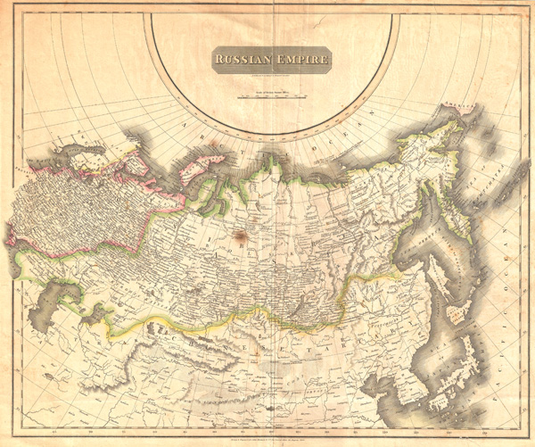
1814 Thomson Map of the Russian Empire in Europe and Asia
1814 (dated) $300.00
1814 Thomson Map of the Russian Empire in Europe and Asia
Russia-thomson-1814$87.50

Title
Russian Empire.
1814 (dated) 20.5 x 25 in (52.07 x 63.5 cm)
1814 (dated) 20.5 x 25 in (52.07 x 63.5 cm)
Description
A large 1814 atlas map of the Russian Empire issued for Edinburgh cartographer John Thomson's New General Atlas. Covers the entirety of the Russian Empire both in Europe and in Asia as well as adjacent parts of Tartary, Chinese Tartary, Japan, Korea, and the Gobi. the disputed sea between Korea and Japan is identified as the 'Sea of Japan.' Engraved by N.R. Hewitt, 10 Broad Street, London.
Cartographer
John Thomson (1777 - c. 1841) was a Scottish cartographer, publisher, and bookbinder active in Edinburgh during the early part of the 19th century. Thomson apprenticed under Edinburgh bookbinder Robert Alison. After his apprenticeship, he briefly went into business with Abraham Thomson. Later, the two parted ways, John Thomson segueing into maps and Abraham Thomson taking over the bookbinding portion of the business. Thomson is generally one of the leading publishers in the Edinburgh school of cartography, which flourished from roughly 1800 to 1830. Thomson and his contemporaries (Pinkerton and Cary) redefined European cartography by abandoning typical 18th-century decorative elements such as elaborate title cartouches and fantastic beasts in favor of detail and accuracy. Thomson's principle works include Thomson's New General Atlas, published from 1814 to 1821, the New Classical and Historical Atlas of 1829, and his 1830 Atlas of Scotland. The Atlas of Scotland, a work of groundbreaking detail and dedication, would eventually bankrupt the Thomson firm in 1830, at which time their plates were sequestered by the court. The firm partially recovered in the subsequent year, allowing Thomson to reclaim his printing plates in 1831, but filed again for bankruptcy in 1835, at which time most of his printing plates were sold to A. K. Johnston and Company. There is some suggestion that he continued to work as a bookbinder until 1841. Today, Thomson maps are becoming increasingly rare as they are highly admired for their impressive size, vivid hand coloration, and superb detail. More by this mapmaker...
Source
Thomson, J., New General Atlas, (London) 1814.
Condition
Average. Some creasing at center and closed slight tear in lower right quadrant. Discoloration at the center o the map just to the left of the centerfold. Overall all toning and some light soiling.
References
Rumsey 1007.039.