
1923 Kaigai Kyokai Map of Sao Paulo State, Brazil, Japanese Emigration

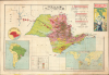

ブラジル国 サンパウロ州之図 / [Map of Sao Paulo State Brazil].
Japanese 'collaborative settler colonialism' in Brazil.
- Digital Map Information
- Suitable for large format printing
- Full resolution TIFF file
- ICC color profile embedded
- Delivered instantly via download link
Japanese 'collaborative settler colonialism' in Brazil.
This is a 1923 Japanese-language map of Sao Paulo State, Brazil, issued jointly by the Nambei Tochi Kumiai and the Kaigai Kyōkai Chūōkai, organizations dedicated to promoting Japanese emigration to South America. In particular, the map relates to migrants from Nagano settling in agricultural colonies cultivating rice, cotton, coffee, sugar, and other commodities. Japanese emigration to South America in particular can be seen as a kind of economic colonialism called by some 'collaborative settler colonialism'.A Closer Look
The main map displays Sao Paulo State with shading according to land use, explained in the legend below. Most of the state consists of coffee plantations (dark green, 咖啡園), sugarcane plantations (light green, 甘蔗園), or areas for rice cultivation (horizontal red lines, 米作地). As can be seen, different parts of the state were more often dedicated to different uses, with coffee being prominent in the central part of the state and sugarcane in the west. Red circles mark the locations of forty-one cities, villages, plantations, and colonies (殖民地) where Japanese emigrants had settled, which are also listed at right with their Spanish names transliterated into Japanese and the crops grown at each noted. A particularly large and important coffee plantation named the Aliança Colony (アリアンサ移住地), operated by the Shinano (i.e., Nagano) Overseas Association (信濃海外協会), is marked with a blue stamp towards the left.The extensive legend on the main map includes lines and symbols for railways, telegraph lines, heavy and light industrial sites, schools, and more. An inset at the bottom-left displays Sao Paulo State within Brazil and South America, while a smaller inset above compares the size of the state to regions of Japan, showing that it was larger than Shikoku, Kyushu, and Honshu combined. An inset at the bottom-right presents a world map showing the distance by maritime route between Japan and São Paulo State via the major shipping companies N.Y.K. (Nippon Yusen Kaisha) and O.S.K. (Osaka Shosen Kaisha). At the top-right is a colorful illustration, presumably the title panel of the map when folded, of a man and woman, Japanese migrants, prospering in their new location; the title above reads 'Handbook of South American Land Association' (南米土地組合便覧).
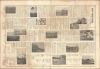
The verso contains photographs and text, giving a general overview of Brazil (its climate, geography, transportation infrastructure, demographics, etc.), a long section on the typical crops grown there, and discussion of concerns such as schools, policing, and healthcare. Tellingly, a section on 'shortcomings' (欠点) and a following section on Living Expenses and Wages (生活費と勞銀) point out some of the difficulties of settling in a new continent, including environmental challenges, issues with transportation, and the complexities of currency exchange. Rather bluntly, the latter section states, 'Brazil is not a place for those whose goal is to earn basic wages and send money back to Japan. Rather, it must be said that it is a place best suited for those who bring capital from Japan, hire local workers, and manage their own operations.' At the bottom is a lengthy statistical reference table laying out 'a calculated estimate of income and expenses for a settler traveling from Japan who purchases and cultivates 37 chō 5 tanbu [about 37.2 hectares or 92 acres] of land in Brazil. This calculation assumes arrival in April and a family of three.' The photographs largely match the text, primarily depicting crop cultivation but also including photographs of schools and curious cultural exchanges, such as 'A Tea Party of Japanese and Brazilians' and 'The Emperor's Birthday Celebration Parade by Japanese Residents in Brazil.'
Historical Context
From the late 19th century, government officials in Japan were eager to promote emigration as a means of alleviating Japan's population crisis, which was also a source of potential social and political volatility. Thousands of Japanese emigrated to Hawaii, California, South America, Southeast Asia, and elsewhere, usually with government support and coordination. For example, in South America, officially sanctioned programs created semi-private corporations to purchase vast swaths of land, especially in Peru and Brazil. The 'colonists' did not necessarily relocate of their own free will and were largely the poor, religious undesirables (Christians), second and third-born sons, and agricultural workers from southern provinces. To this day, Latin American Japanese communities are the largest such outside of Japan.The vast majority of Japanese migrants to Brazil settled in Sao Paulo State, where a booming coffee industry was desperate for farm labor following the abolition of Brazilian slavery in 1888. Initially, these emigrants worked as contract laborers (colonos) on large coffee plantations (fazendas). However, harsh working conditions, debt peonage, language barriers, and low wages quickly convinced many families that long-term survival required moving away from plantation labor toward owning their own land. To achieve economic independence, regional emigration societies and private cooperatives in Japan (in this case the Shinano Land Purchasing, Utilization and Credit Cooperative 信濃土地購買利用信用組合) began purchasing large tracts of frontier land in Sao Paulo to establish planned agricultural colonies. Notable settlements, such as the Aliança Colony in western Sao Paulo highlighted here (founded in 1924 by the Shinano Overseas Association), served as self-sustaining havens complete with Japanese-language schools, credit unions, and cooperative farming.
Publication History and Census
This map was jointly prepared by the South American Land Association (南米土地組合, Nambei Tochi Kumiai) and the Central Association of Overseas Associations (Kaigai Kyōkai Chūōkai, 海外協會中央會), an umbrella organization for various emigration efforts. It was published by Tsuzaki Naotake (津崎尚武) of the Kaigai Kyōkai, a civil servant based in Nagano and all-around enthusiast of Japanese emigration. The map was printed by Nagata Shigeru (永田稠) of the Rikikōkai Printshop (力行會印刷所) in Tokyo, affiliated with the Rikikōkai, another organization dedicated to helping Japanese emigrate that Nagata headed. We are only aware of one institutional holding of this work, at the National Museum of Japanese History (cataloged under the title above the illustration, 南米土地組合便覽).Cartographers
Tsuzaki Naotake (津崎尚武; May 24, 1882 - August 29, 1962) was a Japanese bureaucrat and politician who served in the Japanese Diet before World War II. He was well known as a vocal proponent of Japanese emigration, both within Japan's growing empire (Manchuria, in particular) and further afield. Tsuzaki was born in Kagoshima and studied political science at the Tokyo Imperial University, graduating in 1909. He passed the Higher Civil Service Examination, joined the Ministry of Home Affairs, and served in several high-level roles with the police and general administration of Nagano Prefecture. In 1915, he resigned from government and went to the United States, where he worked for the New York Land and Building Company. He returned to Japan the following year and served as a director of Toa Sangyo Company, Ltd. (東亜産業株式会社). In 1920, he was elected to the Japanese House of Representatives, where he served as the Parliamentary Vice-Minister of Health and Welfare. Tsuzaki was a major proponent of Japanese emigration, serving as vice chairman of the Central Association of Overseas Associations (海外協會中央會), director of the Manchurian Emigration Association (満洲移住協會), director of the Central Association of Overseas Compatriots (海外同胞中央會), and vice chairman of the Greater East Asia Friendship Association (大東亜親善協會). Due to these associations and his membership in the Imperial Rule Assistance Association (the rubber stamp wartime Japanese parliament), Tsuzaki was blacklisted by the American occupation authorities until 1951, after which he unsuccessfully attempted a return to the Japanese Diet. Further Details...
Nagata Shigeru (永田稠; December 30, 1881 - January 2, 1973) was a Japanese emigration manager who played a leading role in several key overseas Japanese settlements. He was born in Nagano and received standard education for the time before starting, but not completing, a political science preparatory course at the Tokyo Professional School (now Waseda University). In 1906, he moved to Hokkaido and the following year traveled to the United States as a member of the Japan Rikko-kai (日本力行会), an organization dedicated to helping Japanese emigrate to the U.S. He stayed in the U.S. for five years and returned to Japan to head Japan Rikko-kai before co-founding the Shinano (i.e. Nagano) Overseas Association (信濃海外協会). From 1924, he was deeply involved in the Aliança Colony (アリアンサ移住地) in Sao Paulo State, Brazil, populated by Nagano emigres. Following Japan's invasion and occupation of Manchuria, Nagata consulted the Kwantung Army's Immigration Department (関東軍移民部) and in 1934 founded a school to train emigre farmers how to thrive in Manchukuo. In 1937, he founded a model colony akin to Aliança near the Manchukuo capital of Xinjing (now Changchun) called Rikko Village (力行村). At the end of World War II, Nagata returned to Japan and afterwards published accounts of his travels and work. Further Details...
Condition
Very good. Some toning. Wear on old fold lines. Soiling on verso.
References
National Museum of Japanese History, H-979-42. Xu Lu, Sidney, Collaborative Settler Colonialism: Japanese Migration to Brazil in the Age of Empires.