1682 Frederick De Wit Map of Scandinavia
Scandinavia-wit-1682$950.00

Title
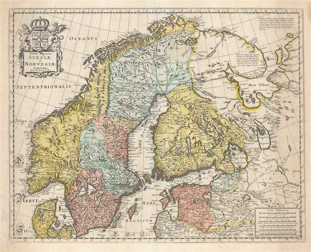
Tabula Regnorum Sueciae et Norvegiae.
1682 (undated) 17.25 x 21.75 in (43.815 x 55.245 cm) 1 : 4200000
1682 (undated) 17.25 x 21.75 in (43.815 x 55.245 cm) 1 : 4200000
Description
This is Frederick de Wit's map of Scandinavia. It is based on Anders Bure's 1626 mapping of the region, which swiftly became the dominant mapping of the northern parts of Europe and was not replaced as an authority for more than a century. On the strength of his seminal map and its long tenure as the state-of-the-art map of the northern regions of Europe, Bure is hailed as the Father of Swedish Cartography. The scope of the map includes Denmark, Norway, the greater Swedish Empire, the Baltic coasts of Germany, Poland and Livonia, and the Russian Empire - including 'Lapponia Moscovitica,' the portions of Lapland occupied by Russia.
Stormaktstiden - 'the Era of Great Power'
The borders reflect the treaty of Roskilde, following the Second Northern War between Sweden and Denmark. This period represented the peak of Swedish Imperial power, until it was checked by Russia in the Great Northern War. Later maps - many of which were derived from this work - would show Livonia, Ingria, and parts of Karelia as no longer Swedish, but held by Russia.The Telltale Cartouche
The title cartouche is surmounted by the royal arms of Sweden, flanked by a Lion and a Gryphon. It is a close copy - reversed, in fact, so possibly even traced - of the cartouche on the 1665 Allard map of Scandinavia. This, doubtless, was De Wit's source for the present work.Publication History and Census
This map was engraved by Jan Lhuillier for inclusion in De Wit's Atlas, probably around 1680 but possibly earlier. De Wit did not include much text in his atlas, and it was seldom dated, which has negatively impacted the precision of the work's cataloging in library collections. We are aware of two states of this map: The present example, which we judge to be a second state, bears a plate number '13' in the upper right border; a like example appears in a De Wit Atlas in Rumsey's collection, dated 1682. A first state, exemplified by the copy in Harvard Library's collection, lacks the plate number. Its date is not catalogued precisely (166-) but we think it cannot be earlier than 1666 (being a copy of the 1665 Allard.) Perhaps fifteen separate examples are listed in OCLC. The map appears on the market from time to time.CartographerS
Frederik de Wit (1629 - 1706) was a Dutch Golden Age cartographer active in the second half of the 17th and the early 18th centuries. De Wit was born of middle class Protestant stock in the western Netherlandish town of Gouda. He relocated to Amsterdam sometime before 1648, where he worked under Willem Blaeu. His first attributed engraved map, a plan of Haarlem for Antonius Sanderus' Flandria Illustrata, was issued around this time. He struck out on his own in 1654. The first chart that De Wit personally both drew and engraved was most likely his 1659 map of Denmark, REGNI DANIÆ Accuratissima delineatio Perfeckte Kaerte van ‘t CONJNCKRYCK DENEMARCKEN. His great wall map of the world and most famous work, Nova Totius Terrarum Orbis Tabula appeared one year later. Following the publication of his wall map De Wit quickly rose in prominence as a both cartographer and engraver. He married Maria van der Way in 1661 and through her became a citizen of Amsterdam in 1662. Around this time he also published his first major atlas, a composite production ranging in size from 17 to over 150 maps and charts. Other atlases and individual maps followed. In 1689 De Wit was granted a 15 year Privilege by the Dutch States General. (An early copyright that protected the recipient's rights to print and publish.) He was recognized with the honorific 'Good Citizen' in 1694. De Wit died in 1706 after which his wife Maria continued publishing his maps until about 1710. De Wit's son, Franciscus, had no interest in the map trade, instead choosing to prosper as a stockfish merchant. On her own retirement, Maria sold most De Wit maps and plates at a public auction. Most were acquired by Pieter Mortier and laid the groundwork for the 1721 rise of Covens and Mortier, the largest Dutch cartographic publishing house of the 18th century. More by this mapmaker...
Anders Bure (August 14, 1571 - February 4, 1646) was a Swedish mathematician and cartographer. He is considered the father of Swedish cartography. He was the son of the parish priest Engelbertus Laurentii and Elisabeth Andersdotter Burea, descendant of the long-established Bureätten family. His immediate family included diplomats and government officials. His education is obscure, though he is mentioned as an office clerk in 1602. His duties in the following years involved recording royal genealogical and historical works, involving him in the highest echelons of Swedish society. He also participated in diplomatic assignments, including missions to both Russia and Finland. His cartographic contributions improved the mapping both of the northern parts of Sweden, and the kingdom as a whole. His six-sheet 1626 Orbis Arctoi represented the first real improvement to the mapping of the northern parts of Europe since the Olaus Magnus map of the previous century: this map would provide the basis for virtually every European map of Scandinavia to follow in the 17th century. In addition to these achievements, he was the first person recorded to use the decimal system in Sweden. Learn More...
Jan Luillier, also L'huillier (fl 1655-1731) was a Dutch engraver - or quite probably a family of engravers, given the longevity implied by the spread of dates associated with the name. 'J. Lhuillier' and 'J. Luillier' appeared on maps in both Amsterdam and in Paris from as early as 1655 to the first decades of the eighteenth century: this imprint appears on the maps of Sanson, DuVal, De Wit, Mariette, and Danet. Despite the long anf prolific spread of the Luillier name, virtually nothing is recorded about Luillier's (or the Luilliers') life and work. Learn More...
Source
Wit, F. De. Atlas (Amsterdam) 1682.
Condition
Very good. Some marginal staining. Hand wash and outline color.
References
OCLC 165495622. Rumsey 12220.068.