
1570 / 1592 Ortelius Map of Slovenia and Environs

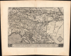
Schlavoniae, Croatiae, Carniae, Istriae, Bosniae, Finitimarumque Regionum Nova Descriptio.
Croatia and the Long Turkish War.
- Digital Map Information
- Suitable for large format printing
- Full resolution TIFF file
- ICC color profile embedded
- Delivered instantly via download link
Croatia and the Long Turkish War.
This is a 1570 / 1592 Abraham Ortelius map of Slovenia, Istria, Croatia, and a portion of Bosnia, based on an earlier map by Augustin Hirschvogel, published in the Theatrum Orbis Terrarum. At the time, these lands stood on the disputed borders of the Ottoman Empire and the Habsburg Holy Roman Empire, a contest referred to in toto as the Ottoman-Habsburg Wars. More specifically, this map was published when the Kingdom of Croatia faced Ottoman threat during the 'Long Turkish War' (also known as the Thirteen Years' War).A Closer Look
The map extends from Carinthia and the northeastern Adriatic eastward across the Sava and Drava basins to the Danube, embracing much of present-day Slovenia, Croatia, and Bosnia and Herzegovina, together with adjoining Austrian, Italian, and Hungarian territory. Most large cities are rendered with their German names: Ljubljana appears as Laybach, Celje as Cilli, Maribor as Marpurg, and so on. Smaller cities and towns more often employ names reflecting Hungarian or local languages. These names place the region's geography within the multilingual landscape of 16th-century central and southeastern Europe.Rivers provide the map's principal organizing framework. The Sava crosses the composition through a succession of tributaries and settlements, while the Drava defines a second eastward corridor farther north. Towns and castles appear as miniature architectural profiles, some enclosed by conspicuous rings of hatching. Rows of rounded trees distinguish extensive forests, while tightly grouped mountain symbols give the Slovenian and Croatian uplands a crowded texture.
The detail becomes noticeably thinner in Lower Bosnia, labeled 'Nider Wossen.' This contrast is best understood as an unevenness in the available geographical information rather than as evidence of an empty country. Hirschvogel's familiarity with the region was grounded partly in residence and travel: he lived in Ljubljana between 1536 and 1543 and visited the Ottoman frontier. His now-lost border map of 1539 is documented in a posthumous inventory. The relationship between this early work and Ortelius's engraving is not completely resolved, but it places the map's cartographic ancestry within the practical demands of understanding a contested frontier. The Adriatic offers a visual counterweight to the densely engraved interior. A small sailing vessel occupies the stippled water beside the islands of the Kvarner Gulf, while elaborate calligraphic lettering names the sea.
Ortelius' 'Second Map of Illyricum'
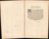
The verso bears the heading 'Illyrici Altera Tabula,' or 'A Second Map of Illyricum.' This is a reference to the fact that editions of the Theatrum from 1573 onwards also included a map titled 'Illyricum' (Rumsey 10001.272). On the verso here, Ortelius briefly explains that he intended to provide only one map of the region, selecting the most accurate available. After Johannes Sambucus (1531 - 1584) supplied what Ortelius regarded as a better representation, he initially planned to omit Hirschvogel's map. But he reconsidered, thinking that different representations of the same country offered useful comparisons, and because readers should not lose material available in the first edition.The 'Long Turkish War'
The Long Turkish War (1593 - 1606), also known as the Thirteen Years' War, was a grueling Habsburg-Ottoman conflict that ignited directly along the Croatian border. Tensions boiled over in June 1593 at the Battle of Sisak, where a combined force led by Croatian Ban Toma Erdődy decisively routed the army of the Bosnian regional governor, Hasan Pasha Predojević. This victory marked the first major Christian field success against an Ottoman army in decades, halting the push toward Zagreb and effectively ending the century-long wave of relentless Ottoman territorial expansion across Croatia. While the war's primary theater soon shifted toward Hungary, the Croatian theater remained an active zone of counter-offensives and trenchant siege warfare that culminated in the 1606 Peace of Zsitvatorok. This treaty established a fragile status quo and restored several vital local strongholds, including Petrinja and Čazma, to Christian control.Beyond these minor territorial shifts, the war fundamentally reshaped Croatia's political and demographic landscape for centuries. To secure this exposed frontier, the Habsburg Crown accelerated the militarization of the Military Frontier (Vojna Krajina), subordinating large stretches of Croatian land to direct imperial military commands in Graz and Vienna rather than the local Croatian Sabor and Ban. Decades of raiding, famine, and captivity had hollowed out the native population, prompting imperial authorities to recruit and resettle thousands of Christian refugees, predominantly Orthodox Serbs and Vlachs, by offering land and hereditary privileges in exchange for lifelong military border duty. This policy entrenched a distinct soldier-peasant society along the border, permanently diversifying the region's demographic fabric and driving an administrative wedge between the militarized borderlands and civil Croatia.
Publication History
The map first appeared in the Antwerp edition of the Theatrum Orbis Terrarum in 1570. It was omitted from several editions of the mid-1570s, returned in 1579, and subsequently appeared in multiple language editions. The current example's Latin verso text, numbering (88), and text ending with the centered words 'candidatis duxi,' identify it as coming from the 1592 Latin edition of the Theatrum.Cartographers
Abraham Ortelius (April 14, 1527 - June 28, 1598) also known as Ortels, was a cartographer, geographer, and cosmographer of Brabant, active in Antwerp. He was the creator of the first modern atlas, Theatrum Orbis Terrarum and is a seminal figure in the history of cartography. Along with Gerard Mercator and Gemma Frisius, he was a founder of the Netherlandish school of cartography. His connections with Spain - culminating in his 1575 appointment as Royal Cartographer to King Phillip II of Spain - gave him unmatched access to Spanish geographical knowledge during a crucial period of the Age of Discovery. Ortelius was born in 1527 in Antwerp. In 1547 he entered the Antwerp Guild of Saint Luke as an illuminator of maps. He began trading in books, prints, and maps, traveling regularly to the Frankfurt book and print fair, where in 1554 he met Mercator. He accompanied Mercator on journeys throughout France in 1560 and it was at this time, under Mercator's influence, that he appears to have chosen his career as a scientific geographer. His first published geographic work appeared in 1564, an eight-sheet cordiform world map. A handful of other maps preceded the 1570 publication of the first edition of the Theatrum Orbis Terrarum, which would prove to be his life work. Appearing with but 53 maps in its first edition, Ortelius' work expanded with new maps added regularly. By 1592, it had 134 maps. Many of Ortelius' maps remained the standard for nearly a century. He traveled extensively, but his genius was as a compiler, locating the best informed maps on which to base his own. His contacts throughout Europe and extending even (via the Portuguese) to the Far East were formidable. Moreover, many of his maps were based on his own scholarship, particularly his historical works. His theories of geography were particularly ahead of his time with respect to the notion of continental drift, the possibility of which he mused on as early as 1596, and which would be proven correct centuries later. In a sense his greatest achievement was his successful navigation of the religious and political violence endemic to his city throughout his adult life: The Dutch Revolt, or Eighty Years' War (1568 - 1648), fully embroiled Antwerp. Although outwardly and officially recognized as Catholic (Arias Montanus vouched for Ortelius' Catholic orthodoxy prior to his appointment as Royal Geographer), Ortelius was able to separate himself from the religious furor which characterized the war in the low countries. Ortelius showed a glimpse of himself in a letter to a friend, regarding humanist Justus Lipsius: 'I do not know whether he is an adherent of the Pope or a Calvinist, but if he has ears to hear, he will neither be one nor the other, for sins are committed on both sides'. Ortelius' own explorations of Biblical history in his maps, and the Christogram contained in his own motto, suggest him to be a religious man, but his abjuration of political religious authorities mark him as an individualist. His tombstone at St Michael's Præmonstratensian Abbey in Antwerp bears the inscription, Quietis cultor sine lite, uxore, prole. ('served quietly, without accusation, wife, and offspring.') Further Details...
Augustin Hirschvogel (1503 - February 1553) was a German cartographer, surveyor, mathematician, and etcher active in Nuremberg, Ljubljana, and Vienna during the first half of the 16th century. Born in Nuremberg, he received his initial training in the workshop of his father, the stained-glass painter Veit Hirschvogel the Elder (1461 - 1525). His early independent career encompassed glassworking, decorative designs, and gem cutting before cartography became an important part of his practice. In 1536 he moved to Ljubljana, then known as Laibach, while retaining his Nuremberg citizenship. His early cartographic projects included a map of the Habsburg-Ottoman borderlands in 1539, a map of Upper Austria in 1542, and maps of Carinthia and Carniola in 1544. His interest in the mathematical foundations of drawing and measurement also found expression in Geometria, published in Nuremberg in 1543. Settling in Vienna in 1544, Hirschvogel undertook commissions for the court, municipal authorities, and private patrons. Appointed the city's cartographer in 1546, he surveyed Vienna and its surroundings, producing a plan in 1547 in connection with the improvement of the city's defenses, together with etched views from the north and south. His survey was subsequently represented on a circular tabletop in 1549 and in an etched plan printed from six plates in 1552. These works combined detailed urban representation with practical military concerns; instruments he called quadrants were intended to assist artillery aiming rather than simply to serve as surveying equipment. In 1552 he traveled to Hungary to undertake a further mapping project, which remained unfinished at his death in Vienna in early February 1553. His earlier borderland map was published posthumously by Hans Weigel in Nuremberg in 1565 and should be distinguished from this final Hungarian undertaking. Further Details...
Source
Ortelius, Abraham, Theatrum Orbis Terrarum, (Antwerp: Plantin Press, 1592).
Condition
Excellent condition. Two wormholes in margins.
References
Rumsey 10000.091. Karrow 40/9 pp. 299-300. Meurer pp. 167. Van de Broecke 145. Koeman Ort 41. Van der Krogt 7601:31 Van den Broecke, Marcel, Cartographica Neerlandica, online cartobibliographic entry Ortelius Map No. 145 and accompanying map-text transcription. Rumsey, 10000.091 (related 1570 edition). National Library of Ireland, MS 48,518 /76. Altić, Mirela, 'Johannes Janssonius's Map of Dalmatia and the Ottoman-Venetian Borderland (1650)', Imago Mundi, 70:1 (2018), pp. 65 - 78, notes 7 - 10.