This item has been sold, but you can get on the Waitlist to be notified if another example becomes available, or purchase a digital scan.
1636 Mercator/ Hondius Map of the Balkans: Croatia, Bosnia, Dalmatia, Sclavonia
SclavoniaCroatia-jansson-1636$250.00

Title
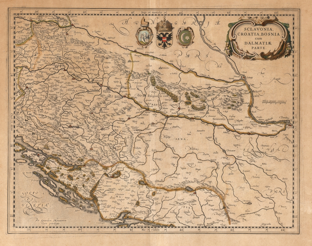
Sclavonia, Croatia, Bosnia cum Dalmatiae Parte.
1636 (undated) 14 x 18.25 in (35.56 x 46.355 cm) 1 : 1000000
1636 (undated) 14 x 18.25 in (35.56 x 46.355 cm) 1 : 1000000
Description
This is a scarce, 1636 English-text edition of Gerard Mercator's map of Croatia, Slovenia, Serbia, and Bosnia and Herzegovina, published by Jansson-Hondius. This is not only from the sole English text edition of the Mercator-Hondius atlas; it is also the first printing of the map to exhibit the newly engraved cartouche and coats of arms (these were absent prior to 1636).
A Closer Look
The map covers the western part of the Balkans from Varazdin, Croatia south to Brac, and from the Adriatic Sea and Arbe east as far as Belgrade. It includes parts of the modern day countries of Croatia, Slovenia, Serbia, and Bosnia and Herzegovina. Mercator presented the region in extraordinary detail, noting rivers, towns, islands, and a host of other topographical features, with forests and mountains beautifully rendered in profile.Keeping Up with the Competition
For the 1636 edition of the Atlas - of which Jansson was taking over production - Mercator's strapwork cartouche has been replaced with Jansson's graceful, garlanded oval. The open space north of the Drava River and west of the Danube has been filled with three armorial medallions, those of the three major powers vying for control over the region: the Republic of Venice, the Habsburg Empire, and the Ottoman Empire. The impetus for these changes was the 1634 publication of Willem Blaeu's map of the same region, and of the same title. The 1634 Blaeu openly copied Mercator's map, adding a new cartouche and the trio of armorials. Jansson, recognizing the need to compete aesthetically with his powerful rival, dutifully made the above changes to the map without altering its content.Keeping Up with Plagiarists
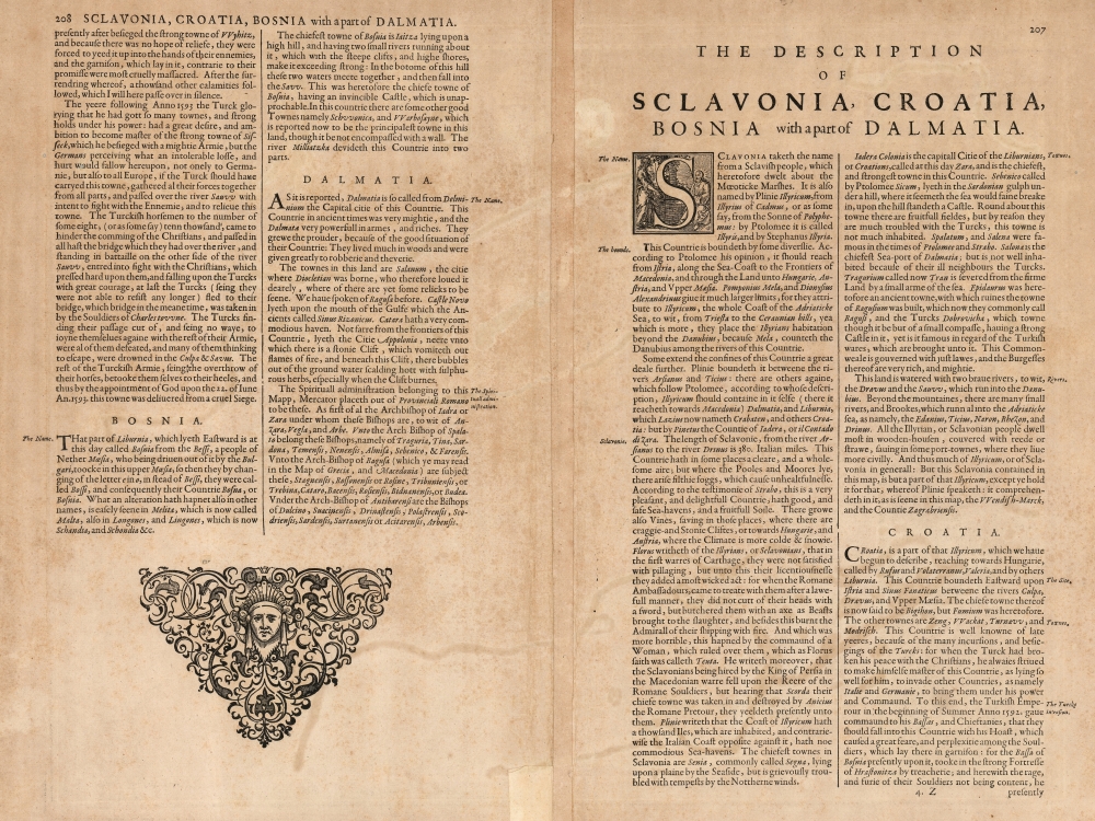
In 1635, the English printers Michael Spark and Samuel Cartwright published an English text edition of the Mercator small-format Atlas Minor. This was an unauthorized edition, but its appearance did alert Hondius and Jansson to the demand for an atlas that existed in England. In response, they produced an English-text edition of the Mercator/ Hondius folio atlas. They were the only major Dutch atlas publisher of the 16th and 17th century to do so. The text - translated to English by soldier and writer Henry Hexham (1585 - 1650) - describes the history of the region, including in particular the invasion of it by the Turkish Empire:… the Turkish Emperour in the beginning of Summer Anno 1592, gave command to his Bassas , and his Chieftanies, that they should fall into this Countrie with his Hoast, which caused a great feare, and perplexitie among the Souldiers, which lay there in garnison…This edition was typeset and printed in Amsterdam, but was shipped to London for binding and sale. Whether by fashion or due to expense, this edition was very rarely colored and it is now quite unusual to find examples of its maps in original color, as we have here.
Publication History and Census
Mercator engraved this map for inclusion in his atlas at some point in the 1590s, but died before it could be seen in print. His heirs first published it in 1595 and it stayed in the Mercator/ Hondius atlases throughout their long publication history. This second state of the map first appeared in the English text edition of 1636. In its many editions the map is well represented in institutional collections, however the English edition is rare and does not appear as a separate map in OCLC.CartographerS
Gerard Mercator (March 5, 1512 - December 2, 1594) is a seminal figure in the history of cartography. Mercator was born near Antwerp as Gerard de Cremere in Rupelmonde. He studied Latin, mathematics, and religion in Rupelmonde before his Uncle, Gisbert, a priest, arranged for him to be sent to Hertogenbosch to study under the Brothers of the Common Life. There he was taught by the celebrated Dutch humanist Georgius Macropedius (Joris van Lanckvelt; April 1487 - July 1558). It was there that he changed him name, adapting the Latin term for 'Merchant', that is 'Mercator'. He went on to study at the University of Louvain. After some time, he left Louvain to travel extensively, but returned in 1534 to study mathematics under Gemma Frisius (1508 - 1555). He produced his first world map in 1538 - notable as being the first to represent North America stretching from the Arctic to the southern polar regions. This impressive work earned him the patronage of the Emperor Charles V, for whom along with Van der Heyden and Gemma Frisius, he constructed a terrestrial globe. He then produced an important 1541 globe - the first to offer rhumb lines. Despite growing fame and imperial patronage, Mercator was accused of heresy and in 1552. His accusations were partially due to his Protestant faith, and partly due to his travels, which aroused suspicion. After being released from prison with the support of the University of Louvain, he resumed his cartographic work. It was during this period that he became a close fried to English polymath John Dee (1527 - 1609), who arrived in Louvain in 1548, and with whom Mercator maintained a lifelong correspondence. In 1552, Mercator set himself up as a cartographer in Duisburg and began work on his revised edition of Ptolemy's Geographia. He also taught mathematics in Duisburg from 1559 to 1562. In 1564, he became the Court Cosmographer to Duke Wilhelm of Cleve. During this period, he began to perfect the novel projection for which he is best remembered. The 'Mercator Projection' was first used in 1569 for a massive world map on 18 sheets. On May 5, 1590 Mercator had a stroke which left him paralyzed on his left side. He slowly recovered but suffered frustration at his inability to continue making maps. By 1592, he recovered enough that he was able to work again but by that time he was losing his vision. He had a second stroke near the end of 1593, after which he briefly lost speech. He recovered some power of speech before a third stroke marked his end. Following Mercator's death his descendants, particularly his youngest son Rumold (1541 - December 31, 1599) completed many of his maps and in 1595, published his Atlas. Nonetheless, lacking their father's drive and genius, the firm but languished under heavy competition from Abraham Ortelius. It was not until Mercator's plates were purchased and republished (Mercator / Hondius) by Henricus Hondius II (1597 - 1651) and Jan Jansson (1588 - 1664) that his position as the preeminent cartographer of the age was re-established. More by this mapmaker...
Jodocus Hondius (October, 14 1563 - February 12, 1612) was an important Dutch cartographer active in the late 16th and early 17th centuries. His common name, Jodocus Hondius is actually a Latinized version of his Dutch name, Joost de Hondt. He is also sometimes referred to as Jodocus Hondius the Elder to distinguish him from his sons. Hondius was a Flemish artist, engraver, and cartographer. He is best known for his early maps of the New World and Europe, for re-establishing the reputation of the work of Gerard Mercator, and for his portraits of Francis Drake. Hondius was born and raised in Ghent. In his early years he established himself as an engraver, instrument maker and globe maker. In 1584 he moved to London to escape religious difficulties in Flanders. During his stay in England, Hondius was instrumental in publicizing the work of Francis Drake, who had made a circumnavigation of the world in the late 1570s. In particular, in 1589 Hondius produced a now famous map of the cove of New Albion, where Drake briefly established a settlement on the west coast of North America. Hondius' map was based on journal and eyewitness accounts of the trip and has long fueled speculation about the precise location of Drake's landing, which has not yet been firmly established by historians. Hondius is also thought to be the artist of several well-known portraits of Drake that are now in the National Portrait Gallery in London. In 1593, Hondius returned to Amsterdam, where he remained until the end of his life. In 1604, he purchased the plates of Gerard Mercator's Atlas from Mercator's grandson. Mercator's work had languished in comparison to the rival atlas, Theatrum Orbis Terrarum by Ortelius. Hondius republished Mercator's work with 36 additional maps, including several which he himself produced. Despite the addition of his own contributions, Hondius recognizing the prestige of Mercator's name, gave Mercator full credit as the author of the work, listing himself as the publisher. Hondius' new edition of Mercator revived the great cartographer's reputation and was a great success, selling out after a year. Hondius later published a second edition, as well as a pocket version called the Atlas Minor. The maps have since become known as the "Mercator/Hondius series". Between 1605 and 1610 Hondius was employed by John Speed to engrave the plates for Speed's The Theatre of the Empire of Great Britaine. Following Hondius' death in 1612, his publishing work in Amsterdam was continued by his widow and two sons, Jodocus II and Henricus. Later his family formed a partnership with Jan Jansson, whose name appears on the Atlasas co-publisher after 1633. Eventually, starting with the first 1606 edition in Latin, about 50 editions of the Atlas were released in the main European languages. In the Islamic world, the atlas was partially translated by the Turkish scholar Katip Çelebi. The series is sometimes called the 'Mercator/Hondius/Jansson' series because of Jansson's later contributions. Hondius' is also credited with a number of important cartographic innovations including the introduction of decorative map borders and contributions to the evolution of 17th century Dutch wall maps. The work of Hondius was essential to the establishment Amsterdam as the center of cartography in Europe in the 17th century. Learn More...
Jan Jansson or Johannes Janssonius (1588 - 1664) was born in Arnhem, Holland. He was the son of a printer and bookseller and in 1612 married into the cartographically prominent Hondius family. Following his marriage he moved to Amsterdam where he worked as a book publisher. It was not until 1616 that Jansson produced his first maps, most of which were heavily influenced by Blaeu. In the mid 1630s Jansson partnered with his brother-in-law, Henricus Hondius, to produce his important work, the eleven volume Atlas Major. About this time, Jansson's name also begins to appear on Hondius reissues of notable Mercator/Hondius atlases. Jansson's last major work was his issue of the 1646 full edition of Jansson's English Country Maps. Following Jansson's death in 1664 the company was taken over by Jansson's brother-in-law Johannes Waesberger. Waesberger adopted the name of Jansonius and published a new Atlas Contractus in two volumes with Jansson's other son-in-law Elizée Weyerstraet with the imprint 'Joannis Janssonii haeredes' in 1666. These maps also refer to the firm of Janssonius-Waesbergius. The name of Moses Pitt, an English map publisher, was added to the Janssonius-Waesbergius imprint for maps printed in England for use in Pitt's English Atlas. Learn More...
Source
Hondius, H. / Jansson, J., Atlas, or, A geographicke description of the regions, counties and kingdomes of the world..., (Amsterdam: Hondius) 1636.
Mercator's Atlas is one of the most important works in the history of cartography. Although in fact Ortelius was the first to publish a proper atlas, the Teatrum Orbis Terrarum, Mercator's work the first book to employ the term Atlas for a collection of maps. The term is derived both from the mythical titan, Atlas, who was forced to bear the world upon his shoulders, and the Libyan king, philosopher, and astronomer of the same name that, so the legend goes, constructed the first globe. Mercator dedicated the final 25 years of his life to compile the Atlas. He published two parts during his lifetime in 1585 and 1589, but the final part published posthumously by his son Rumold Mercator, in 1595. The map plates for the Atlas were later acquired by Jodocus Hondius who published the most complete and well known edition in 1606. It was Jodocus who popularized the Atlas and who did the most to elevate Gerard Mercator's name.
Condition
Very good. Evenly toned. Creasing parallel to centerfold. Marginal mend at bottom not impacting printed image. Original color.
References
OCLC 633553408 (German, 1638).