
1797 Laurie and Whittle Nautical Map of Senegal and Gambia - Slave Trade


This item has been sold.
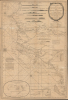
A New Survey of the Coast of Africa from Senegal and Cape Verd to Cape St. Ann.
Made for slavers, by slavers.
- Digital Map Information
- Suitable for large format printing
- Full resolution TIFF file
- ICC color profile embedded
- Delivered instantly via download link
Made for slavers, by slavers.
This is a 1797 nautical map of West Africa detailing the coast and inland river systems from Senegal to Sierra Leone. The chart was issued by Laurie and Whittle, but made for the African slave trade based on the most up-to-date and detailed reports of prominent slave ship captains Robert Norris (1791) and William Woodville Jr. (1795). It appeared at the height of the Triangle Trade when countless Africans were captured and sold into captivity in the Americas. As such, the chart offers significant insights into the Transatlantic Slave Trade.A Closer Look
The map includes the modern-day countries of Senegal, The Gambia, Guinea-Bissau, Guinea, and Sierra Leone. A wealth of detail relevant to both the navigator and the slave trader line the coast: names of indigenous African nations, sites of European factories, forts, entrepôts, prominent landmarks, and annotations on the country and peoples. Windheads show the direction of prevailing winds, and arrows illustrate currents. Soundings, shoals, hazards, anchorages, bottoms, and other navigational information are marked. Eleven profiles views and five inset maps are included. A track follows the course of Capt. William Woodville Jr.'s ship Rodney on its 1791 voyage, which disembarked some 300 slaves at Montego Bay, Jamaica.British Factories on the Gambia
Of particular interest is the detailed mapping of the Gambia River based on the work of Francis Moore, a factor with the Royal African Company in the Gambia between 1730 and 1735. Moore was deeply involved in the slave and ivory trades. His journals, intended to support the slave trade, were subsequently used by abolitionists to express that very institution's vile inhumanity. The mapping exposes the deep British penetration into the Gambia, with Factories and trading centers extending as far as Barraconda Falls, a rapid located some 257 miles upriver. Of note, 'Kiawer or Cower', a major African slave market, is highlighted.Factory Island and the Îles de Los
One of the most significant updates is the inclusion of Woodville's 1777 survey of the Îles de Los - bottom right. The islands rose to prominence for their role as ship careening depots for the Atlantic slave trade. In 1755, Miles Barber of the African Company of Liverpool established a factory there for ship repair. The settlement also maintained a staff of pilots-for-hire who knew local rivers and inland trade routes.Historical Context
This chart appeared in the late 18th century, a period that marked both the peak of the Triangle Trade and the beginning of its decline. Although most European nations participated the foul commerce of slavery, the majority of slave ship captains were British. Captains would sail to Africa from European ports, but most often Liverpool, where slaves were acquired from allied African nations - most the spoils of inter-tribal wars - then transported to the Americas, where they were sent to work in sugar and tobacco plantations. The slave ship captains would then load up on sugar, tobacco, fruits, cotton, and other products before returning to Europe - restarting the wildly profitable cycle.As the trade increased, public outcry for abolition also increased. Around the time this map was issued, there was virulent debate in the British Parliament over slavery. Two of the slave ship captains named here, Norris and Woodville, testified before Parliament in support of the trade. After more than two decades of debate, Parliament finally outlawed British involvement in the slave trade in 1807.
Publication History and Census
This chart is one of those Laurie and Whittle acquired from the stock of Robert Sayer, who first published it in 1792. This chart features extensive updates, courtesy of Woodville, who was working with Laurie and Whittle as of 1795. Earlier mapping is likely attributable to another notorious slaver, Robert Norris, whose name is mentioned in several places on the map. Rare. In the OCLC, we see two examples of the 1792 Sayer edition, one example of the 1794 Laurie and Whittle edition, and one example of the present 1797 edition, held by the Bibliothèque nationale de France.Cartographer
Laurie and Whittle (fl. 1794 - 1858) were London, England, based map and atlas publishers active in the late 18th and early 19th century. Generally considered to be the successors to the Robert Sayer firm, Laurie and Whittle was founded by Robert Laurie (c. 1755 - 1836) and James Whittle (1757-1818). Robert Laurie was a skilled mezzotint engraver and is known to have worked with Robert Sayer on numerous projects. James Whittle was a well-known London socialite and print seller whose Fleet Street shop was a popular haunt for intellectual luminaries. The partnership began taking over the general management of Sayer's firm around 1787; however, they did not alter the Sayer imprint until after Sayer's death in 1794. Apparently Laurie did most of the work in managing the firm and hence his name appeared first in the "Laurie and Whittle" imprint. Together Laurie and Whittle published numerous maps and atlases, often bringing in other important cartographers of the day, including Kitchin, Faden, Jefferys and others to update and modify their existing Sayer plates. Robert Laurie retired in 1812, leaving the day to day management of the firm to his son, Richard Holmes Laurie (1777 - 1858). Under R. H. Laurie and James Whittle, the firm renamed itself "Whittle and Laurie". Whittle himself died six years later in 1818, and thereafter the firm continued under the imprint of "R. H. Laurie". After R. H. Laurie's death the publishing house and its printing stock came under control of Alexander George Findlay, who had long been associated with Laurie and Whittle. Since, Laurie and Whittle has passed through numerous permeations, with part of the firm still extant as an English publisher of maritime or nautical charts, 'Imray, Laurie, Norie and Wilson Ltd.' The firm remains the oldest surviving chart publisher in Europe. Further Details...
Condition
Good. Even toning. Wear and some repaired (older repairs) splits and minor tears on old fold liens.
References
OCLC 1339078172.