This item has been sold, but you can get on the Waitlist to be notified if another example becomes available, or purchase a digital scan.
1662 Jansson Map of Ancient Sicily
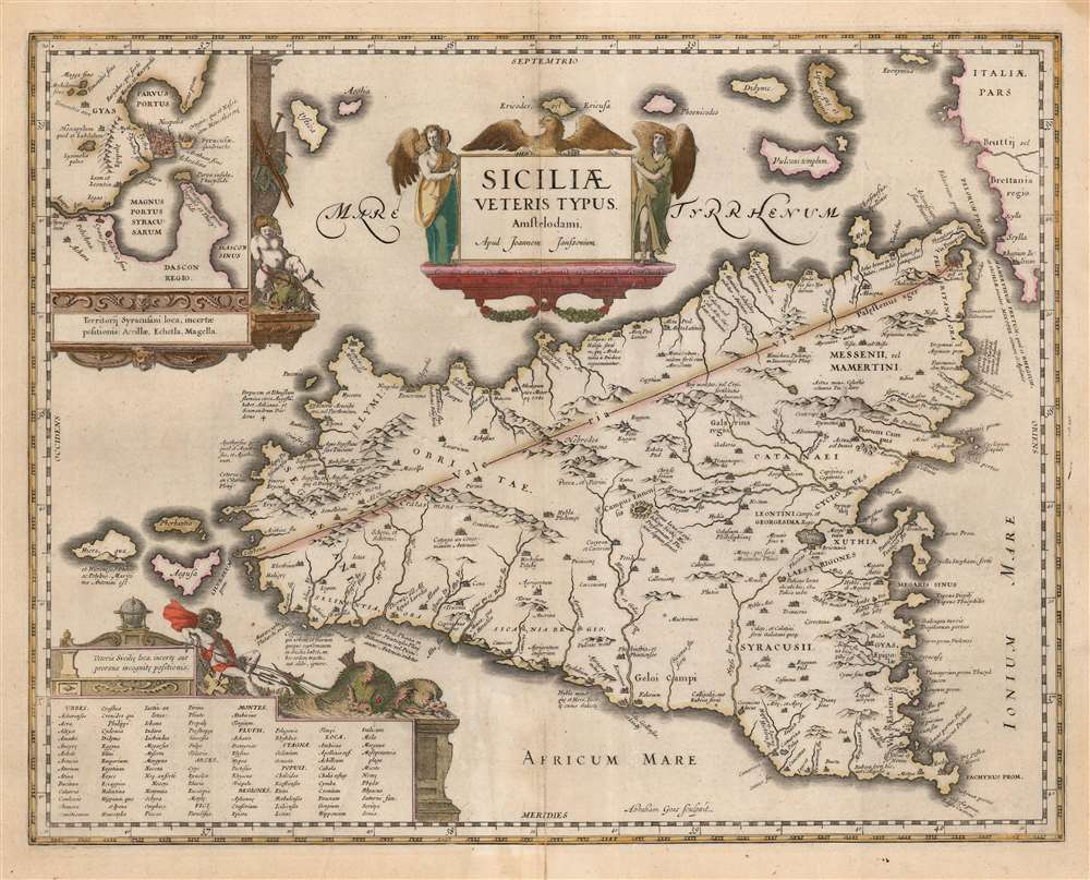
Sicily-jansson-1618$425.00

Title
Siciliae Veteris Typus Amstelodami Apud Joannem Janssonium.
1618 (undated) 15 x 19 in (38.1 x 48.26 cm) 1 : 820000
1618 (undated) 15 x 19 in (38.1 x 48.26 cm) 1 : 820000
Description
This is Joannes Jansson's map of Sicily in antiquity. In its 1618 edition, it is among the earliest maps to carry Jansson's imprint. This attractive map was first produced for inclusion in an atlas of ancient geography written by Petrus Bertius, and draws upon Ortelius' map of Ancient Sicily published in the Parergon.
Ortelius the Historian
Ortelius is well known as a compiler of maps - most of the maps in his Theatrum were carefully sourced from the best sources available to him and cited. He was himself an eager historian, and his classical and Biblical atlas Parergon was the product of his own research distilling classical sources such as Strabo and Ptolemy. Koeman's gloss on the work explains:'This atlas of ancient geography must be regarded as a personal work of Ortelius. For this work he did not, as in the Theatrum, copy other people's maps but drew the originals himself... He took many places and regions from the lands of classical civilization to illustrate and clarify their history, a subject very close to his heart... The maps and plates of the Parergon have to be evaluated as the most outstanding engravings depicting the wide-spread interest in classical geography in the 16th century.The present map faithfully reproduces Ortelius' historical geography. The basic geographical model for the map of the island was drawn from Giacomo Gastaldi's 1545 map of Sicily, but the place names and much of the topography are drawn from Ortelius' own interpretations of classical sources.
A View of Classical Syracuse
The upper left of the engraving contains an inset map of the city of Syracuse and its immediate vicinity, derived largely from the reports of Virgil and Thucydides. The details include the Fountain of Arethusa, a fountain on Ortygia, the historical city center. This fresh water fountain was reputed to be where Syracuse's patroness, the nymph Arethusa, returned to earth's surface after escaping from her undersea home in Arcadia.Historical and Mythical Locations
Many of the features included here are of concrete historical nature, although some of are placed with more confidence than was deserved. For example, the map places Sicily's Via Valeria running straight from Lilybaeum (modern Marsala) to Messina (The Via Valeria actually hewed to the coastline.) Much of the detail comes from the pages of Greek mythology. The volcano Etna is here noted as the 'Pillar of Heaven.' At the center of the island appears 'Lake Pergus, also the navel of Sicily. Here Prosperina was captured by Pluto.' The lake does indeed exist. It is the site of the famous racetrack Autodromo di Pergusa, the ruins of an old fortified village, and an ancient temple dedicated to Demeter. Of the coastline northwest of Messina, it is noted that in antiquity it was believed the cattle of the sun god were stabled there (the same cattle of Helios molested by Odysseus' crew, incurring their divine punishment and Odysseus' unendurable servitude to the nymph Calypso.) The passage between Sicily and the tip of the Italian boot features the sites of the Homeric Scylla and Charybdis, the twin perils that menaced Odysseus.Fashionably Updated
While adhering to Ortelius' content, Jansson's composition displays his seventeenth-century aesthetic. Ortelius' strapwork cartouches and framing have been replaced with more elaborate, figured imagery. The garlanded cartouche, surmounted with a Sicilian eagle, is flanked by angels. In the frame of the inset map, a putto wrangles a saddled-and-bridled sea monster. At the bottom left, a table of ancient place names (of whose locations Ortelius was uncertain) is peaked with a globe; reclining on the frame is a wind-blown Neptune, with two sea monsters straining on the leash.Publication History and Census
Jansson composed this map, and it was engraved in 1618 by Abraham Goos for inclusion in Petrus Bertius' Hondius-published Theatrum geographiae veteri. Hondius and Jansson included the map in many editions of their atlases. This specific example typographically corresponds to the 1662 Latin edition of Jansson's Atlas Novus. The map is well represented in institutional collections, and appears on the market from time to time.CartographerS
Jan Jansson or Johannes Janssonius (1588 - 1664) was born in Arnhem, Holland. He was the son of a printer and bookseller and in 1612 married into the cartographically prominent Hondius family. Following his marriage he moved to Amsterdam where he worked as a book publisher. It was not until 1616 that Jansson produced his first maps, most of which were heavily influenced by Blaeu. In the mid 1630s Jansson partnered with his brother-in-law, Henricus Hondius, to produce his important work, the eleven volume Atlas Major. About this time, Jansson's name also begins to appear on Hondius reissues of notable Mercator/Hondius atlases. Jansson's last major work was his issue of the 1646 full edition of Jansson's English Country Maps. Following Jansson's death in 1664 the company was taken over by Jansson's brother-in-law Johannes Waesberger. Waesberger adopted the name of Jansonius and published a new Atlas Contractus in two volumes with Jansson's other son-in-law Elizée Weyerstraet with the imprint 'Joannis Janssonii haeredes' in 1666. These maps also refer to the firm of Janssonius-Waesbergius. The name of Moses Pitt, an English map publisher, was added to the Janssonius-Waesbergius imprint for maps printed in England for use in Pitt's English Atlas. More by this mapmaker...
Abraham Ortelius (April 14, 1527 - June 28, 1598) also known as Ortels, was a cartographer, geographer, and cosmographer of Brabant, active in Antwerp. He was the creator of the first modern atlas, Theatrum Orbis Terrarum and is a seminal figure in the history of cartography. Along with Gerard Mercator and Gemma Frisius, he was a founder of the Netherlandish school of cartography. His connections with Spain - culminating in his 1575 appointment as Royal Cartographer to King Phillip II of Spain - gave him unmatched access to Spanish geographical knowledge during a crucial period of the Age of Discovery. Ortelius was born in 1527 in Antwerp. In 1547 he entered the Antwerp Guild of Saint Luke as an illuminator of maps. He began trading in books, prints, and maps, traveling regularly to the Frankfurt book and print fair, where in 1554 he met Mercator. He accompanied Mercator on journeys throughout France in 1560 and it was at this time, under Mercator's influence, that he appears to have chosen his career as a scientific geographer. His first published geographic work appeared in 1564, an eight-sheet cordiform world map. A handful of other maps preceded the 1570 publication of the first edition of the Theatrum Orbis Terrarum, which would prove to be his life work. Appearing with but 53 maps in its first edition, Ortelius' work expanded with new maps added regularly. By 1592, it had 134 maps. Many of Ortelius' maps remained the standard for nearly a century. He traveled extensively, but his genius was as a compiler, locating the best informed maps on which to base his own. His contacts throughout Europe and extending even (via the Portuguese) to the Far East were formidable. Moreover, many of his maps were based on his own scholarship, particularly his historical works. His theories of geography were particularly ahead of his time with respect to the notion of continental drift, the possibility of which he mused on as early as 1596, and which would be proven correct centuries later.
In a sense his greatest achievement was his successful navigation of the religious and political violence endemic to his city throughout his adult life: The Dutch Revolt, or Eighty Years' War (1568 - 1648), fully embroiled Antwerp. Although outwardly and officially recognized as Catholic (Arias Montanus vouched for Ortelius' Catholic orthodoxy prior to his appointment as Royal Geographer), Ortelius was able to separate himself from the religious furor which characterized the war in the low countries. Ortelius showed a glimpse of himself in a letter to a friend, regarding humanist Justus Lipsius: 'I do not know whether he is an adherent of the Pope or a Calvinist, but if he has ears to hear, he will neither be one nor the other, for sins are committed on both sides'. Ortelius' own explorations of Biblical history in his maps, and the Christogram contained in his own motto, suggest him to be a religious man, but his abjuration of political religious authorities mark him as an individualist. His tombstone at St Michael's Præmonstratensian Abbey in Antwerp bears the inscription, Quietis cultor sine lite, uxore, prole. ('served quietly, without accusation, wife, and offspring.') Learn More...
Abraham Goos (1590 - 1643) was a Dutch engraver of maps, sea charts, and globes based in Antwerp and Amsterdam. He was born in Haarlem, the sone of diamond cutter Pieter Goos and Margaret van de Keere. Through is mother he was related to engraver Pieter van den Keere (Petrus Kaerius; 1571 - 1646), the brother-in-law of map publisher Jodocus Hondius (1563 - 1612). He was likely trained in engraving by Kaerius, as his first known work is a collaboration on the 1614 terrestrial globe of Petrus Plancius. He went on to engrave for Joannes Jansson, Jocodus Hondius, and John Speed. One of his most significant works is the Holy Land map of Yaacov ben Avraham Aladdin, considered one of the earliest printed maps in Hebrew. Abraham Goos was succeeded by his son Pieter Goos (1616 - 1675), who was in tern succeeded by his son Henrik Goos. Learn More...
Source
Jansson, Jan., Atlas Novus, (Amsterdam: Jansson) 1662.
Condition
Very good. Mend to bottom centerfold just entering printed surface. Some marginal waterstaining well away from borders. Generous margins and attractive original color.
References
OCLC 867001107. Rumsey 11296.128. Van der Krogt, P. C. J., Koeman's Atlantes Neerlandici, (3 Vols), 7510H:1.2.