This item has been sold, but you can get on the Waitlist to be notified if another example becomes available, or purchase a digital scan.
1608 Vrients Edition of Ortelius' Map of Ancient Sicily
Sicily-ortelius-1608$750.00

Title
Siciliae Veteris Typus ex Conatibus geographicis Ab. Ortelij.
1608 (dated) 14.5 x 19 in (36.83 x 48.26 cm) 1 : 825000
1608 (dated) 14.5 x 19 in (36.83 x 48.26 cm) 1 : 825000
Description
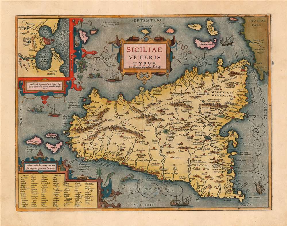
This is a superb example of Ortelius' map of Sicily as it was known in antiquity. The map is noteworthy for highlighting Ortelius' scholarship as a historian, as well as for denoting the locations of many sites from classical antiquity and mythology. This example is noteworthy as being from the Jan Bapatista Vrients (1552 - 1612) edition, which are known for exceptionally rich original colorwork.
Ortelius the Historian
Ortelius is well known as a compiler of maps - most of the maps in his Theatrum were carefully sourced from the best sources available to him and cited. He was himself an eager historian, and his maps in his classical and Biblical atlas Parergon tended to be the product of his own research distilling classical sources such as Strabo and Ptolemy. Koeman's gloss on the work explains:'This atlas of ancient geography must be regarded as a personal work of Ortelius. For this work he did not, as in the Theatrum, copy other people's maps but drew the originals himself... He took many places and regions from the lands of classical civilization to illustrate and clarify their history, a subject very close to his heart... The maps and plates of the Parergon have to be evaluated as the most outstanding engravings depicting the wide-spread interest in classical geography in the 16th century.The present map is a superb example of Ortelius' historical geography. The basic geographical model for the map of the island is drawn from Giacomo Gastaldi's 1545 map of Sicily, but the place names and much of the topography are drawn from Ortelius' own interpretations of classical sources.
A View of Classical Syracuse
The upper left of the engraving contains a strapwork-framed inset map of the city of Syracuse and its immediate vicinity, derived largely from the reports of Virgil and Thucydides. The details include the Fountain of Arethusa, the fountain on the island of Ortygia in the historical center of the city. This fresh water fountain was reputed to be the place where Syracuse's patroness, the nymph Arethusa, returned to earth's surface after escaping from her undersea home in Arcadia.Historical and Mythical Locations
Many of the features included here are of concrete historical nature, although some of are placed with more confidence than was deserved. For example, Ortelius places Sicily's Via Valeria running straight from Lilybaeum (modern Marsala) to Messina (The Via Valeria actually hewed to the coastline.) Much of the detail comes from the pages of Greek mythology. The volcano Aetna is here noted as the 'Pillar of Heaven.' At the center of the island appears 'Lake Pergus, also the navel of Sicily. Here Prosperina was captured by Pluto.'The lake does indeed exist. It is the site of the famous racetrack Autodromo di Pergusa the ruins of an old fortified village, with walls constructed around the 9th millennium BC, and an ancient temple most appropriately dedicated to Demeter. (Demeter being the mother of Persephone, the Greek analog for Prosperina.) Of the coastline northwest of Messina, it is noted that in antiquity it was believed the cattle of the sun god were stabled there (the same cattle of Helios molested by Odysseus' crew, incurring their divine punishment and Odysseus' unendurable servitude to the nymph Calypso.) The passage between Sicily and the tip of the Italian boot features the sites of the Homeric Scylla and Charybdis, the twin perils that menaced Odysseus back when he still had a ship and a crew.Publication History and Census
Ortelius' map was engraved in 1584 and appeared in all subsequent editions of Ortelius' Biblical and historical atlas, Parergon, which was itself generally bound into Ortelius' Theatrum. This specific example matches van den Broecke state 5, and typographically corresponds to the map appearing in the 1608 Italian edition of Theatrum / Parergon. This edition was published by Ortelius executor, Vrients, whose editions of the atlas are prized for their unusually rich and beautiful hand coloring (evident in the present example).CartographerS
Abraham Ortelius (April 14, 1527 - June 28, 1598) also known as Ortels, was a cartographer, geographer, and cosmographer of Brabant, active in Antwerp. He was the creator of the first modern atlas, Theatrum Orbis Terrarum and is a seminal figure in the history of cartography. Along with Gerard Mercator and Gemma Frisius, he was a founder of the Netherlandish school of cartography. His connections with Spain - culminating in his 1575 appointment as Royal Cartographer to King Phillip II of Spain - gave him unmatched access to Spanish geographical knowledge during a crucial period of the Age of Discovery. Ortelius was born in 1527 in Antwerp. In 1547 he entered the Antwerp Guild of Saint Luke as an illuminator of maps. He began trading in books, prints, and maps, traveling regularly to the Frankfurt book and print fair, where in 1554 he met Mercator. He accompanied Mercator on journeys throughout France in 1560 and it was at this time, under Mercator's influence, that he appears to have chosen his career as a scientific geographer. His first published geographic work appeared in 1564, an eight-sheet cordiform world map. A handful of other maps preceded the 1570 publication of the first edition of the Theatrum Orbis Terrarum, which would prove to be his life work. Appearing with but 53 maps in its first edition, Ortelius' work expanded with new maps added regularly. By 1592, it had 134 maps. Many of Ortelius' maps remained the standard for nearly a century. He traveled extensively, but his genius was as a compiler, locating the best informed maps on which to base his own. His contacts throughout Europe and extending even (via the Portuguese) to the Far East were formidable. Moreover, many of his maps were based on his own scholarship, particularly his historical works. His theories of geography were particularly ahead of his time with respect to the notion of continental drift, the possibility of which he mused on as early as 1596, and which would be proven correct centuries later.
In a sense his greatest achievement was his successful navigation of the religious and political violence endemic to his city throughout his adult life: The Dutch Revolt, or Eighty Years' War (1568 - 1648), fully embroiled Antwerp. Although outwardly and officially recognized as Catholic (Arias Montanus vouched for Ortelius' Catholic orthodoxy prior to his appointment as Royal Geographer), Ortelius was able to separate himself from the religious furor which characterized the war in the low countries. Ortelius showed a glimpse of himself in a letter to a friend, regarding humanist Justus Lipsius: 'I do not know whether he is an adherent of the Pope or a Calvinist, but if he has ears to hear, he will neither be one nor the other, for sins are committed on both sides'. Ortelius' own explorations of Biblical history in his maps, and the Christogram contained in his own motto, suggest him to be a religious man, but his abjuration of political religious authorities mark him as an individualist. His tombstone at St Michael's Præmonstratensian Abbey in Antwerp bears the inscription, Quietis cultor sine lite, uxore, prole. ('served quietly, without accusation, wife, and offspring.') More by this mapmaker...
Johannes Baptista Vrients (1552 - 1612) was a Flemish engraver, publisher, and mapseller. Little is known of his early years, but it is to be assumed he came up as an apprentice among the mapmakers of Antwerp, where the guild named him a master in 1575. In the 1590s, he executed world maps for Plancius and Linschoten. (In 1600, after Ortelius died, he became the estate's executor and acquired the plates for the Theatrum.) He would go on to publish further editions of the Ortelius atlas between 1606 and 1612. Vrients also acquired the plates for Gerard De Jode's (1516/17 - 1591) Speculum in and around 1600, but he did not republish that work - though he would preserve the De Jode plates depicting the Electors of the Holy Roman Empire, reprinting it in his editions of the Ortelius atlas after 1603. Most likely, his purchase of the De Jode plates was a play to keep them off the market. Vrients' editions of the Theatrum were not published in Antwerp (that city having fallen during the Dutch war with Spain) but in Amsterdam. Learn More...
Giacomo Gastaldi (c. 1500 - October, 1566) was an Italian astronomer, cartographer, and engineer active in the second half of the 16th century. Gastaldi (sometimes referred to as Jacopo or Iacobo) began his career as an engineer, serving the Venetian Republic in that capacity until the fourth decade of the sixteenth century. During this time he traveled extensively, building a large library relating to voyages and exploration. From about 1544 he turned his attention to mapmaking, working extensively with Gextantiovanni Battista Ramusio, Nicolo Bascarini, and Giovanbattista Pedrezano, as well as taking private commissions for, among others, Venice's Council of Ten. He is credited with the fresco maps of Asia and Africa still extant in the map room of the Doge's Palace. Gastaldi was also one of the first cartographers to embrace copper plate over woodblock engraving, marking an important development in the history of cartography. His 1548 edition of Ptolemy's Geographia was the first to be printed in a vernacular; it was the first to be printed in copperplate. As with his Swiss/German contemporary Münster, Gastaldi's work contained many maps depicting newly discovered regions for the first time, including the first map to focus on the East Coast of North America, and the first modern map of the Indian Peninsula. His works provided the source for the vast majority of the Venetian and Roman map publishers of the 1560s and 70s, and would continue to provide an outsize influence on the early maps of Ortelius, De Jode, and Mercator. Learn More...
Condition
Excellent. Marginal reinforcements at extremes of centerfold, not impacting printed image. Some marginal staining well away from borders. Generous margins and superb original color.
References
OCLC 867001107. Rumsey 10001.397. van den Broecke, M. Ortelius Atlas Maps: An illustrated Guide (second edition) 211.5.