
1745 Mannevillette First Edition Nautical Chart of the South China Sea and Philippines

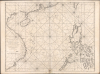

Carte Plate Qui comprend les Coste de Tsiompa, de la Cochinchine, le Golfe de Tunquin, une partie des Costes de la Chine aves une partie de l'Archipel des Isles Philippines.
Suppressed and groundbreaking first edition!
- Digital Map Information
- Suitable for large format printing
- File Size: 47.63 MB
- File Type: ZIP / TIFF
- ICC color profile embedded
- Delivered instantly via download link
Suppressed and groundbreaking first edition!
This is the exceedingly rare 1745 nautical map of the South China Sea and the Philippines, which appeared in Mannevillette's banned first edition of his groundbreaking nautical atlas, the Neptune Oriental. When published, this chart represented the finest available cartography of the South China Sea, Southeast China Coast, and the Philippines - thus defining the Canton-Macao-Manila triangle. It was so accurate that French authorities, fearing for the security of their colonial empire, ordered all examples banned and destroyed. The map is additionally notable for its early and idiosyncratic inclusion of various islands, banks, and atolls in the area, many of which have become hotly disputed in recent decades.A Closer Look
The chart covers from the southern Chinese coast and Formosa (Taiwan) to the coasts of Cochinchine and Cambodia (around the Mekong Delta) in the west and the island of Palawan (Pacagoa here) in the east, including most of the South China Sea. Rhumb lines crisscross the chart, providing a navigational aid to sailors trying to transit these waters (mostly going to or coming from Canton). Soundings are provided along the coasts of Vietnam, through the Qiongzhou Strait between Hainan and the Chinese mainland, and along the Chinese coast, particularly around the mouth of the Pearl River. Hazards, shoals, and other features are also labeled.This includes the very curious and disproportionately large presentation of the Paracel Islands towards left, as well as the nearby 'Lunettes ou le Cordon de St. Anthoine' (also known in old sources as L'Amphitrite), and other features in the South China Sea. The 'Banc des Anglois' near the Paracels is the Macclesfield Bank, today called Zhongsha by China but in the Qing period called the 'Red Hair Shallows' (紅毛淺), 'red hairs' being a common means of referring to Westerners, particularly the Dutch and English. Further north, Pratas Island (Dongsha) and the St. Esprit Shoal (Zhongsha) are also prominently recorded. Hazards to the west of Palawan (one labeled Calambula) likely refer to the Spratly Islands (Nansha).
The China Trade and Canton
The context for this map is the insatiable desire of Western traders, operating through chartered monopolies like the British East India Company and the French Compagnie des Indes, to directly access the extremely desirable goods produced by China (silk, tea, lacquerware, and porcelain, above all) and sell them back in Europe or elsewhere, at a handsome profit if all went well. European traders, beginning with the Portuguese, had been active on the China coast since the 16th century, but had not been able to establish an enduring hegemony over trade routes as they had elsewhere.Over the preceding century, the Qing Dynasty which gained control of China in 1644, had approached maritime trade warily, recognizing that wealthy traders on China's south coast (who were also often government officials or related to them) had profited under the preceding Ming Dynasty and were not inclined to be well-disposed to Manchus from beyond the Great Wall. Indeed, the greatest threat to the Qing Dynasty in its early decades was a trading-pirate empire based on Taiwan led by Coxinga (Zheng Chenggong, 1624 - 1662), the son of one such Ming merchant-bureaucrat from Fujian. It was Coxinga who expelled the Dutch from Fort Zeelandia on Taiwan, referred to at top-right here, and who was planning an invasion of Spanish Manila when he died suddenly in 1662. Had he succeeded, Zheng could have controlled the essential waterways between the Chinese mainland, Taiwan, and the Philippines, and perhaps beyond. Instead, his successors were eventually crushed by a Qing invasion of Taiwan in 1683.
Afterward, feeling more secure, the Kangxi Emperor (r. 1661 - 1722) opened multiple Chinese ports to trade, including Canton (Guangzhou), allowing trade with foreigners to operate through designated Chinese trading firms (hang 行, often as 'hongs' in Western sources), who were tasked with sending a tax on trade to the court. Over time, a parallel and symbiotic system of Chinese and Western trading operations developed, as well as frequent attempts to circumvent this system to avoid the tax. Canton became the preferred port for Western traders who generally travelled seasonally with the monsoon winds. Foreign traders, who initially stayed on their ships continuously, were eventually allowed to establish permanent warehouses (factories) in a walled-off area along the Pearl River, across the river from the walled city of Canton. Although extremely lucrative, Western traders were already chafing at limitations imposed by the Qing by the time of Mannevillette's visit, and Qing responses to foreign traders' attempts to circumvent the system resulted in even more restrictive and formalised rules, called by historians the 'Canton System,' implemented from 1757 until First Opium War (1839 - 1842).
A Censored First Edition
All maps from the 1745 first edition of the Neptune Oriental are as significant as they are rare. The atlas followed Mannevillette's 1728 voyage to China, wherein, using the most up-to-date hydrographic instruments, he corrected latitudes and made new groundbreaking charts. When Mannevillette returned to France, he published the new maps, including charts of the Persian Gulf, the Red Sea, the coasts of India, Malaya, the northern parts of Indonesia, Indochina, and China. His Neptune Oriental, published for the Compagnie des Indes (French East India Company), appeared in 1745 and featured 25 groundbreaking maps.In reviewing the work, the French Admiralty considered the information contained to be so accurate and so advanced over earlier charts that it was a threat to French colonial and maritime interests in the Far East. According to Filliozat, 'the French Admiralty considering that the Neptune Oriental was too dangerous... navigation, ordered the remaining copies to be destroyed' (Filliozat, Manonmani, Indian Journal of History of Science, 292, 1994, p. 341). Consequently, despite much revised and expanded issues of the Neptune Orientale appearing in 1775 (59 maps) and 1775 - 1781, the important first edition remains exceedingly rare. While the 1775 edition is common, we note only three surviving examples of the 1745 edition in the OCLC.
With regard to this specific chart (and several others), despite the French efforts at secrecy, Mannevillette maintained correspondence with the emerging British hydrographer par excellence Alexander Dalrymple (1737 - 1808). By the 1770s, information controls were less stringent, and Dalrymple was able to issue 'A Chart of the China Sea Inscribed to Monsr. d'Apres de Mannevillette the Ingenious Author of the Neptune Oriental…,' which was based on the present chart, with some modifications due to his own observations and other research. In the later issues of the Neptune Oriental, this map did not appear, with smaller, select sections of the coastline appearing instead, while Dalrymple continued to update his 'Chart of the China Sea' until his death (last issued posthumously c. 1810).
Publication History and Census
This chart was engraved by Guillaume d'Heulland for the 1745 first edition of D'Après de Mannevillette's Neptune Oriental. Like all the maps from this edition, most examples were censored and destroyed. However, unlike many of the other maps in the atlas, it was not included in the 1775 and later reissues, making this an exceptionally rare map. We see examples of the separate chart only at the Bibliothèque Nationale de France. The full 1745 edition of the atlas is known at the Library of Congress and the Bibliothèque Nationale de France.Cartographers
Jean-Baptiste Nicolas Denis d'Après de Mannevillette (February 11, 1707 - March 1, 1780) was a French sailor, navigator, and hydrographer active in the mid-18th century. Mannevillette was born in Le Havre to a family of wealthy seafarers. He completed his first major voyage at 12, when he accompanied his father, Jean-Baptiste-Claude d'Après de Blangy, a captain of the Compagnie des Indes (French East India Company) vessel Solide to Bengal. On his return to France, he he studied mathematics and navigation in Paris under Joseph Nicholas De L'Isle (1688 - 1768) before returning to the sea at 19 as a fourth officer as on the merchant vessel Marechel d'Estrees. Mannevillette himself eventually attained the rank of Captain with the Compagnie des Indes. In the course of numerous voyages around Africa to India and China, Mannevillette collected and revised numerous nautical charts. His sophisticated use of the most modern instruments, most specifically the Octant or English Quarter, and keen mathematical mind, enabled Mannevillette to correct many significant errors common to earlier maps. These updates were eventually compiled and published in Mannevillette's most significant work, the 1745 Le Neptune Oriental. The 1745 Neptune Oriental was commissioned by the Compagnie des Indes and its production earned Mannevillette admission into the Academy of Sciences. The atlas was well received, but shortly after publication, most unsold examples were destroyed by the French Admiralty, who considered the secrets of East Indian navigation too dangerous for dissemination. In 1762 the Compagnie des Indes appointed Mannevillette director of chart at Lorient. In 1767 King Louis XV conferred the Order of St. Michael upon him and made him an associate of the Royal Marine Academy. In the 30 years following his first publication of Le Neptune Oriental, Mannevillette worked doggedly with his lifelong friend, Alexander Dalrymple (1737 - 1808) to update his original work with new and improved charts. In 1775, he republished his opus in a greatly expanded format - by this time nautical information was less tightly guarded. Mannevillette died on March 1, 1780 at 75 years of age. Further Details...
Guillaume d'Heulland (c. 17?? - 1770) was a prolific French engraver active in Paris during the mid-18th century; his known work spans from 1731 to 1766. Most of his work focuses on maps, scientific diagrams, and architectural plans. He engraved nautical charts for the French Royal Navy; he engraved many maps and charts for Jacques Nicolas Bellin (1703 - 1772), as well as for Pierre François Xavier de Charlevoix (1682 – 1761), César-François Cassini de Thury (1714 - 1784), and Antoine-François Prevost (1697 - 1763). He appears to have engraved most, if not all of the charts for D'Après de Mannevillette's 1745 Neptune Oriental. He is perhaps best known for his 1756 Plan of Paris. The engraver Choffard was one of his apprentices. Further Details...
Source
Après de Mannevillette, Jean-Baptiste-Nicolas-Denis, Le Neptune Oriental, ou Routier Général des Côtes des Indes Orientales et de la Chine, (Paris) 1745.
Le Neptune Oriental was a large-scale maritime atlas first issued in 1745 by Jean-Baptiste Nicolas Denis d'Après de Mannevillette, a wealthy French sailor and hydrographer. From his first voyage as an adult in 1726, Mannevillette collected, revised, and created new nautical charts. These he published 20 years later in the first edition of Le Neptune Oriental, an important work issued for the Compagnie des Indes (French East India Company), for whom Mannevillette was a captain. The first edition of Le Neptune Oriental, containing 25 charts, was received and earned him accolades in both navigational and scientific circles. Nonetheless, according to Manonmani Filliozat, writing in the Indian Journal of the History of Science,
The French Admiralty, considering that the Neptune Oriental was too dangerous ... ordered the remaining copies to be destroyed. (#292, 1994, p. 341)This accounts somewhat for the extreme scarcity of the first edition and all of the maps contained therein. We also note a supportive comment in a 1763 catalog of maps and charts issued by the French chart and map dealer Roch-Joseph Julien (1745 - 1779). Mannevillette nonetheless continued to collect and revise charts for the next 30 years, often working with the important English cartographer Alexander Dalrymple (1737 - 1808). In 1775, he issued a greatly expanded and updated second edition of Le Neptune Oriental. The new edition featured an additional 41 charts, making a total of 63 charts. This edition also proved popular and was widely disseminated. As noted by multiple cartobibliographers, there are variations between examples, and no two seem to be identical, suggesting that many were compiled to order, often with additional maps that could be purchased but which were not in the standard collation. The second edition was published in Paris by Demonville and in Brest by Malassis. In 1781, one year after Mannevillette's, another work, Supplement au Neptune Oriental was issued, also by Demonville and Malassis.
Condition
Very good. Some staining at bottom centerfold just entering image; some reinforcement to centerfold, else excellent.
References
OCLC 494628917. Bibliothèque nationale de France, département Cartes et plans, GE DD-2987 (7130 B), also GE SH 18 PF 181 P 18/1.