1873 Weller Sketch Map of Southern Taiwan (Formosa)
SouthernFormosa-weller-1873$650.00
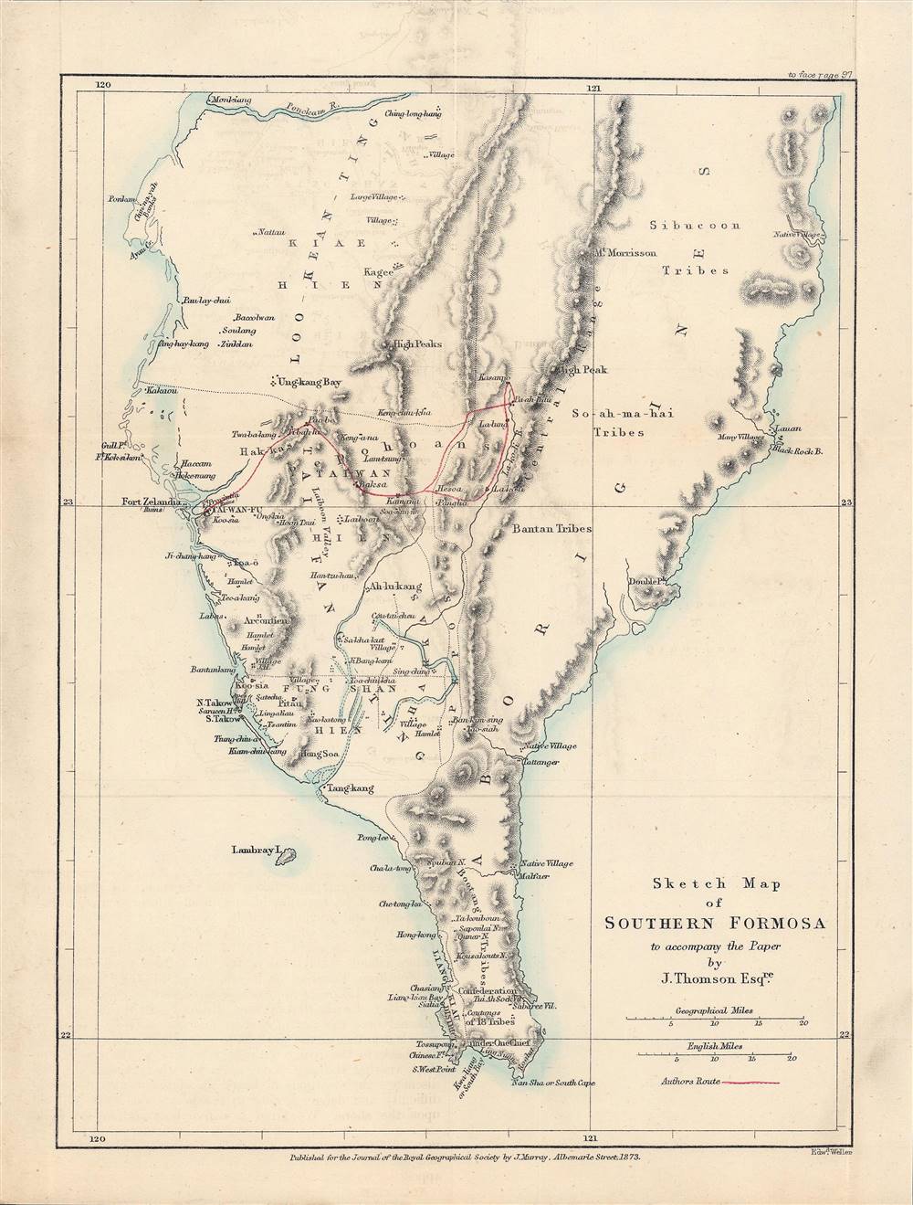

Title
Sketch Map of Southern Formosa.
1873 (dated) 11.25 x 8.5 in (28.575 x 21.59 cm)
1873 (dated) 11.25 x 8.5 in (28.575 x 21.59 cm)
Description
This is a rare 1873 lithograph of the southern tip of Taiwan, published for the The Journal of the Royal Geographical Society. It encapsulates the geographical knowledge gained during an 1871 trip through southern Taiwan by the geographer and photographer John Thomson and his companion, the missionary James Laidlaw Maxwell.
In the second half of the 19th century, both Western and Japanese interest in Taiwan increased as it was seen as a useful and strategically important staging point for naval forces and a source of raw materials. Both the U.S. and Japan launched punitive expeditions against the island after shipwrecked sailors were killed by Taiwanese aborigines (the American expedition was a disaster). France attempted and failed to seize the island in the 1885 Sino-French War and the Qing Dynasty, which had historically tended to see the island as a headache, became more interested in developing and administering it to prevent seizure by a foreign power. Nevertheless, Japan was granted the island in the Treaty of Shimonoseki (1895) and colonized it for the next fifty years.
After stopping at Kaohsiung (高雄, here called Takow), the pair traveled to the prefectural capital of Taiwan-fu (now Tainan); the ruins of the Dutch Forst Zelandia and Provintia are noted nearby. The pair then moved through lowland settlements in the Western Plains and on to aboriginal settlements near the central mountain range. Though their trip was brief, barely over two weeks, their descriptions and Thomson's photographs remain an important source of information about Taiwan prior to the Japanese colonization.
A Closer Look
The map focuses on the southern half of Taiwan, with some areas much more detailed than others, mostly in accordance with areas that Thomson and Maxwell visited. Nevertheless, areas largely unexplored were still recorded, often just as 'village,' 'hamlet,' native village,' 'high peaks,' and so on. Much of the area that Thomson and Maxwell traveled through had seen extensive immigration from Fujian in the preceding decades, to the extent that the aboriginal population was far outnumbered and at least partially assimilated in the lowlands.Taiwan's Relationship with Outside Powers
Europeans had visited, built forts, and even set up government administration on Taiwan in the 17th century, but were driven off by a confederation of trader-pirates led by the Fujianese Zheng family. Soon afterward, the Ming Dynasty fell, and the island was captured by the Qing, who administered it primarily to prevent a revival of the Zheng.In the second half of the 19th century, both Western and Japanese interest in Taiwan increased as it was seen as a useful and strategically important staging point for naval forces and a source of raw materials. Both the U.S. and Japan launched punitive expeditions against the island after shipwrecked sailors were killed by Taiwanese aborigines (the American expedition was a disaster). France attempted and failed to seize the island in the 1885 Sino-French War and the Qing Dynasty, which had historically tended to see the island as a headache, became more interested in developing and administering it to prevent seizure by a foreign power. Nevertheless, Japan was granted the island in the Treaty of Shimonoseki (1895) and colonized it for the next fifty years.
John Thomson and James Laidlaw Maxwell
John Thomson was one of the first photographers to visit East Asia, bringing the most advanced photographic technology to the region in the 1860s and 1870s. While in China, he met Maxwell, who like him was Scottish, and who had been based in Taiwan for much of the previous decade. Thomson was intrigued by Maxwell's description of Taiwan and wanted to visit and photograph it.After stopping at Kaohsiung (高雄, here called Takow), the pair traveled to the prefectural capital of Taiwan-fu (now Tainan); the ruins of the Dutch Forst Zelandia and Provintia are noted nearby. The pair then moved through lowland settlements in the Western Plains and on to aboriginal settlements near the central mountain range. Though their trip was brief, barely over two weeks, their descriptions and Thomson's photographs remain an important source of information about Taiwan prior to the Japanese colonization.
Publication History and Census
This map was made by Edward Weller, a pioneer in the field of lithography, and was published by John Murray, a well-established publishing house in London. It appeared in Vol. 43 of The Journal of the Royal Geographical Society in 1873, accompanying the article 'Notes of a Journey in Southern Formosa' by John Thomson. Examples of the intact journal are scarce, but the separate map is held by Princeton University and the National Museum of Taiwan History Scarce to the market.CartographerS
Edward Weller (July 1, 1819 - 1884) was a cartographer and engraver based in London. Weller was a nephew of another well-known map publisher Sidney Hall (1788 - 1831), who gave him 50 Pounds to pay his apprenticeship fees. He engraved for many prominent mapmakers and was active enough in the community to be recommended for membership to the Royal Geographical Society in 1851 on the recommendation of John Arrowsmith, among others. He eventually inherited the Sidney Hall map business which led him to follow Arrowsmith as the unofficial geographer to the Royal Geographical Society. Weller was among the first map printers in London to embrace lithography. His best known work appears in Cassell's Weekly Dispatch Atlas, published in monthly segments for subscribers of the 'Weekly Dispatch' newspaper. This collection of maps eventually grew to include much of the known world. Published in various editions from 1855 through the early 1880s. Weller died in May of 1884, leaving behind a successful business and an unhappy widow. His son, Francis Sidney Weller (1849 - 1910), followed in his father's footsteps and continued the family map business. The atlas Mackenzie's Comprehensive Gazetteer of England and Wales was published in 1894 and bore F. S. Weller's signature on the maps. More by this mapmaker...
Royal Geographical Society (fl. 1830 - present) is a British Society established in 1830 to promote geographical science and exploration. Originally titled the "Geographical Society of London", the RGS received its royal charter from Queen Victoria in 1859 shortly after absorbing several similar but more regional societies including the African Association, the Raleigh Club and the Palestine Association. The RGS sponsored many of the most important and exciting voyages of exploration ever undertaken, including the exploration of Charles Darwin, David Livingstone, Robert Falcon Scott, Richard F. Burton, John Speke, George Hayward, H. M Stanley, Ernest Shackleton and Sir Edmond Hillary. Today, the RGS remains a leading global sponsor of geographical and scientific studies. The Society is based in Lowther Lodge, South Kensington, London. Learn More...
John Murray I (1737 - 1793) founded the British publishing firm John Murray (1768 - present) in London. Born in Edinburgh, Murray served as an officer in the Royal Marines and built a list of authors that included Isaac D’Israeli and published the English Review. Murray the elder also was one of the founding sponsors of the London evening newspaper The Star in 1788. John Murray II (November 27 1778 - June 27, 1843) continued the family publishing business and developed it into one of the most important and influential publishing houses in Britain. The list of authors published by the firm grew to include Jane Austen, Sir Walter Scott, Washington Irving, George Crabbe, and Lord Byron under his tenure. Murray II also moved the business to 50 Albermarle Street in Mayfair, which became famous for Murray’s tradition of ‘four o’clock friends’, which was afternoon tea with his writers. John Murray III (1808 - 1892) continued to grow the business, and the firm published the first English translation of Goethe’s Theory of Colours, David Livingstone’s Missionary Travels and Charles Darwin’s Origin of Species during his tenure. Murray also published Herman Melville’s first two books. The firm began publishing Murray Handbooks in 1836, an ancestor of all modern travel guides. Sir John Murray IV (1851 - 1928) was publisher to Queen Victoria. Three successive Murray’s after Murray IV led the business until it was purchased by Hodder Headline in 2002, which was acquired by the French conglomerate Lagardère Group in 2004. Today, Murray is an imprint of Lagardère under the imprint Hachette UK. Learn More...
Condition
Very good.