This item has been sold, but you can get on the Waitlist to be notified if another example becomes available, or purchase a digital scan.
1816 Thomson Map of the Southern Hemisphere
SouthernHemisphere-thomson-1816$250.00

Title
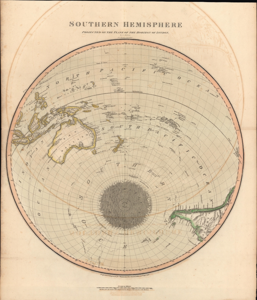
Southern Hemisphere Projected on the Plane of the Horizon of London.
1816 (dated) 25 x 21 in (63.5 x 53.34 cm) 1 : 41000000
1816 (dated) 25 x 21 in (63.5 x 53.34 cm) 1 : 41000000
Description
An unusual offset polar projection map of the Southern Hemisphere, drawn and engraved in 1816 for the 1817 Dublin printing of John Thomson's New General Atlas. Among other features, it highlights the relatively recent voyages of Captain James Cook, including discoveries along the coasts of New Zealand and Australia.
A Closer Look
Centered on the southern Pacific Ocean, coverage ranges from the Sandwich Islands (Hawaii), well north of the Equator, to Antarctica and the southern Atlantic Ocean. The perspective adopted is unusual and highly distinctive, being centered on 'the horizon of the plane of London' (in reality, New Zealand sits near center) rather than the South Pole or the Equator. The voyages of Captain James Cook are traced, demonstrating their importance for filling in much of the geography of the Pacific and the coasts of Antarctica. Still, some coastlines and other geographic features remain hypothetical or cursory (such as New Britain, today part of Papua New Guinea). Notes of interest to navigators, such as currents, the extent of ice, and anything else that might be of use in the vast ocean, including the location where a 'peice [sic] of wood seen,' are recorded. Canton (Guangzhou) appears at top-left, just over the horizon and outside the 'neatline' circle surrounding the map, reflecting its importance to Britain's global trade networks at the time.Publication History and Census
This map was prepared by George Buchanan and engraved by John and George Menzies in 1816 for inclusion in John Thomson's New General Atlas, which went through multiple printings in Edinburgh, London, and Dublin between 1815 and 1817. Examples of the map display different pagination (or none at all, as here) and other details depending on the printing.CartographerS
John Thomson (1777 - c. 1841) was a Scottish cartographer, publisher, and bookbinder active in Edinburgh during the early part of the 19th century. Thomson apprenticed under Edinburgh bookbinder Robert Alison. After his apprenticeship, he briefly went into business with Abraham Thomson. Later, the two parted ways, John Thomson segueing into maps and Abraham Thomson taking over the bookbinding portion of the business. Thomson is generally one of the leading publishers in the Edinburgh school of cartography, which flourished from roughly 1800 to 1830. Thomson and his contemporaries (Pinkerton and Cary) redefined European cartography by abandoning typical 18th-century decorative elements such as elaborate title cartouches and fantastic beasts in favor of detail and accuracy. Thomson's principle works include Thomson's New General Atlas, published from 1814 to 1821, the New Classical and Historical Atlas of 1829, and his 1830 Atlas of Scotland. The Atlas of Scotland, a work of groundbreaking detail and dedication, would eventually bankrupt the Thomson firm in 1830, at which time their plates were sequestered by the court. The firm partially recovered in the subsequent year, allowing Thomson to reclaim his printing plates in 1831, but filed again for bankruptcy in 1835, at which time most of his printing plates were sold to A. K. Johnston and Company. There is some suggestion that he continued to work as a bookbinder until 1841. Today, Thomson maps are becoming increasingly rare as they are highly admired for their impressive size, vivid hand coloration, and superb detail. More by this mapmaker...
John Menzies (October 27, 1772 - October 16, 1857) was a Scottish engraver active in Edinburgh during the late 18th and early 19th centuries. Menzies mastered engraving as an apprentice to James Rymer. In 1811, he partnered with his younger brother, George Menzies, to found the engraving firm of J. and G. Menzies, which was active until about 1831. Later his son, also named John, joined the firm and they engraved jointly under the imprint of J. Menzies and Son. At its height, the Menzies firm employed three men and three apprentices. Menzies engraved maps for Thomas Brown and John Thomson, among others. After his death, his son, John Menzies II (1819 – 1891), continued the family business until about 1891. Learn More...
Source
Thomson, J., A New General Atlas, (Edinburgh) 1817.
Thomson's New General Atlas was first published in 1817 and continued to be published until about 1821. This is the first of Thomson's major cartographic works and the atlas for which is most celebrated. The New General Atlas follows in the Edinburgh School, which eschews excessive decoration in favor of a more minimalistic fact-based cartographic vision, as established by John Pinkerton, Laurie and Whittle, John Cary, and others in the previous decades. The maps are notable for their massive scale, heavy stock, elegant color work, and easy-to-read typefaces. Although the atlas stopped being published after 1821, Thomson continued to offer 'supplementary' maps that could be tipped into the atlas as late as 1830, when he declared bankruptcy. The maps in the Thomson Atlas were engraved by Thomas Clerk, William Dassauville, Nathaniel Rogers Hewitt, James Kirkwood, Robert Kirkwood, John Menzies, George Menzies, Edward Mitchell, John Moffatt, Samuel John Neele, Robert Scott, and James Wyld.
Condition
Good. Offsetting. Light soiling.
References
Rumsey 1007.008.