This item has been sold, but you can get on the Waitlist to be notified if another example becomes available, or purchase a digital scan.
1870 Ravenstein Map of the Southwestern United States
SouthwesternUS-ravenstein-1870$175.00

Title
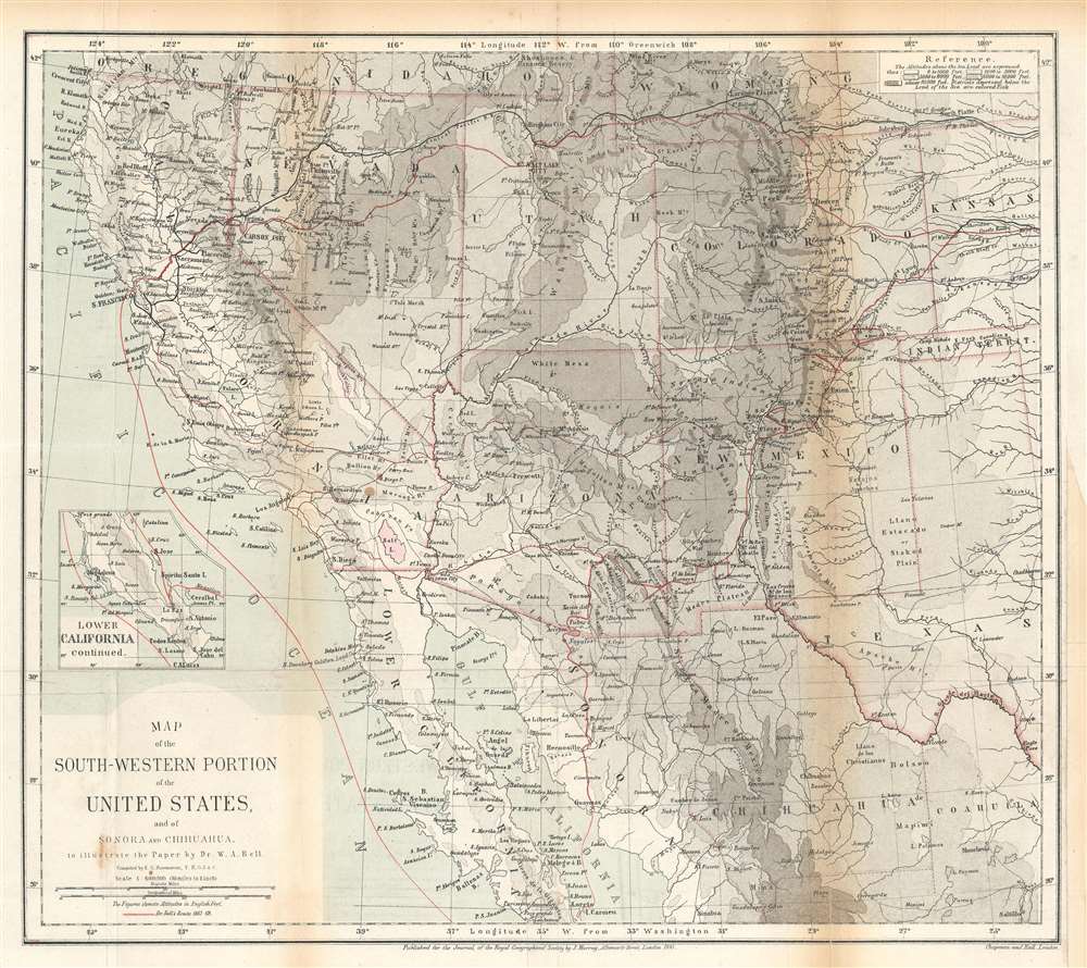
Map of the Southwestern Portion of the United States, and of Sonora and Chihuahua.
1870 (dated) 13.5 x 15.25 in (34.29 x 38.735 cm) 1 : 6000000
1870 (dated) 13.5 x 15.25 in (34.29 x 38.735 cm) 1 : 6000000
Description
This is an 1870 Ernst Georg Ravenstein map of the southwestern United States. The map traces William Abraham Bell's travels in the region, including his time with the Kansas Pacific Railroad Survey. A red line illustrates Bell's peregrinations from Kansas west to the Pacific Ocean, his voyage up the Pacific coast to San Francisco, and his overland trek back to Kansas. From Kansas, Bell headed east where he booked passage across the Atlantic to England. After the expedition Bell co-founded the Denver and Rio Grande Railway.
The Map Itself
A highly detailed piece compiled by Ravenstein, cities, towns, forts, and other settlements are labeled throughout the region, including Denver, Albuquerque, Taos, Santa Fe, San Diego, San Luis Obispo, San Francisco, Carson City, and Salt Lake City. Mountains ranges and individual peaks, including Pike's Peak near Colorado City, are also identified. Rivers and lakes are illustrated in surprising detail. An inset map along the left border illustrates the southern portion of Baja California and Bell's sea voyage around the peninsula.William Abraham Bell, the Kansas Pacific Railroad, and His Trek Across the United States
William Abraham Bell (April 26, 1841 - June 6, 1921) was an English physician and a well-known photographer of the American West. Bell arrived in the United States in 1867, intending to study homeopathy in St. Louis. Instead, Bell joined the Kansas Pacific Railway's survey to identify the best railroad route between Kansas and California. The expedition's geographer recommended Bell to be the expedition's photographer, even though Bell had no photography experience. He undertook a two-week crash course and then went off to meet the expedition in western Kansas. As an aside: history best remembers Bell for a photograph of a mutilated U.S. soldier he took in Kansas in 1867 that was published in Harper's Weekly. This photograph caused the Kansas Pacific to fear that Bell hoped to make money off the photographs he took while on the expedition, so they hired another photographer. However, the expedition split into two parties, and Bell continued south with that party until it reached Camp Grant, about six months after he left Kansas. There, he abandoned his photography equipment (including all the negatives) and headed south to the Mexican coast on horseback. From here, Bell took a ship to San Francisco and then traveled overland back to Kansas, and from there back to England. His travels inspired him to invest in the American west and in 1870 he partnered with William Jackson Palmer (1836-1909) to found the Denver and Rio Grande Railway.Publication History and Census
This map was compiled by Ernst Georg Ravenstein, engraved by Chapman and Hall, and published by John Murray for the Royal Geographical Society. It accompanied Bell's article entitled, 'On the Basin of the Colorado and the Great Basin of North America' published in 1870 for Volume 39 of The Journal of the Royal Geographical Society. Three examples are cataloged in OCLC and are part of the institutional collections at the Newberry Library, the University of Kansas Archives, and Texas Tech University. A fourth example is part of the institutional collection at Princeton University.CartographerS
Ernst Georg Ravenstein (December 30, 1834 - March 13, 1913), also known as Ernest George was a German-English cartographer and geographer. Born in Frankfurt-am-Main, Germany, Ravenstein was the son of the German cartographer and publisher Friedrich August Ravenstein (1809 - 1881), founder of Ravenstein's Geographische Verlagsanstalt (1830 - 2001). Likely fleeing political instability in Germany, he emigrated to England in 1851 or 1852. Upon arrival he immediately became a pupil of Dr. August Heinrich Petermann, also a German exile in England. He subsequently became a naturalized British subject and worked in the topographical-statistical office of the British War Office from 1855 until 1875. He was a member of the Royal Statistical Society and the Royal Geographical Society, and held the position of Professor of Geography at Bedford College from 1882 - 1883. In 1902, the Royal Geographical Society awarded him the first Victoria Gold Medal. Ravenstien is best known for his groundbreaking 'Rules of Migration' a detailed study of human movement. After nearly 60 years abroad, Ravenstein returned to Germany, where he died on March 13, 1913 in Hofheim, just outside his native Frankfurt. Throughout Ernst's time in England, his younger brother Ludwig Ravenstein (1838 - 1915), ran the family business in Frankfurt. More by this mapmaker...
John Murray I (1737 - 1793) founded the British publishing firm John Murray (1768 - present) in London. Born in Edinburgh, Murray served as an officer in the Royal Marines and built a list of authors that included Isaac D’Israeli and published the English Review. Murray the elder also was one of the founding sponsors of the London evening newspaper The Star in 1788. John Murray II (November 27 1778 - June 27, 1843) continued the family publishing business and developed it into one of the most important and influential publishing houses in Britain. The list of authors published by the firm grew to include Jane Austen, Sir Walter Scott, Washington Irving, George Crabbe, and Lord Byron under his tenure. Murray II also moved the business to 50 Albermarle Street in Mayfair, which became famous for Murray’s tradition of ‘four o’clock friends’, which was afternoon tea with his writers. John Murray III (1808 - 1892) continued to grow the business, and the firm published the first English translation of Goethe’s Theory of Colours, David Livingstone’s Missionary Travels and Charles Darwin’s Origin of Species during his tenure. Murray also published Herman Melville’s first two books. The firm began publishing Murray Handbooks in 1836, an ancestor of all modern travel guides. Sir John Murray IV (1851 - 1928) was publisher to Queen Victoria. Three successive Murray’s after Murray IV led the business until it was purchased by Hodder Headline in 2002, which was acquired by the French conglomerate Lagardère Group in 2004. Today, Murray is an imprint of Lagardère under the imprint Hachette UK. Learn More...
Chapman and Hall (fl. 1830 - present) was a British publishing house in London, founded in 1830 by Edward Chapman and William Hall. Upon Hall's death in 1847, Chapman's cousin Frederic Chapman became partner in the company, of which he became sole manager upon the retirement of Edward Chapman in 1864. In 1868 author Anthony Trollope bought a third of the company for his son, Henry Merivale Trollope. From 1902 to 1930 the company's managing director was Arthur Waugh. In the 1930s the company merged with Methuen, a merger which, in 1955 participated in forming the Associated Book Publishers. The latter was acquired by The Thomson Corporation in 1987. Chapman and Hall was sold again in 1998 as part of Thomson Scientific and Professional to Wolters Kluwer, who sold on its well-regarded mathematics and statistics list to CRC Press. Today the name of Chapman and Hall/CRC is used as an imprint for science and technology books by Taylor and Francis, part of the Informa group since 2004. The company is best known for its publication of the works of Charles Dickens (from 1840 until 1844 and again from 1858 until 1870), William Thackeray, Elizabeth Barrett Browning, Eadweard Muybridge and Evelyn Waugh. They continued to publish hitherto unpublished Dickens material well into the 20th century. In cartographic circles they are known as the primary publishers of the Society for the Diffusion of Useful Knowledge Atlas, a massive 200+ map atlas that was popular in England during the mid-19th century. Learn More...
Royal Geographical Society (fl. 1830 - present) is a British Society established in 1830 to promote geographical science and exploration. Originally titled the "Geographical Society of London", the RGS received its royal charter from Queen Victoria in 1859 shortly after absorbing several similar but more regional societies including the African Association, the Raleigh Club and the Palestine Association. The RGS sponsored many of the most important and exciting voyages of exploration ever undertaken, including the exploration of Charles Darwin, David Livingstone, Robert Falcon Scott, Richard F. Burton, John Speke, George Hayward, H. M Stanley, Ernest Shackleton and Sir Edmond Hillary. Today, the RGS remains a leading global sponsor of geographical and scientific studies. The Society is based in Lowther Lodge, South Kensington, London. Learn More...
Source
Bell, W. A., 'On the Basin of the Colorado and the Great Basin of North America', The Journal of the Royal Geographical Society Vol. 39 (London: John Murray) 1869.
Condition
Very good. Exhibits toning and light wear along original fold lines. Verso repairs to fold separations. Blank on verso.
References
Princeton University Library G4212.G7C2 1870 .R6. OCLC 57663546.