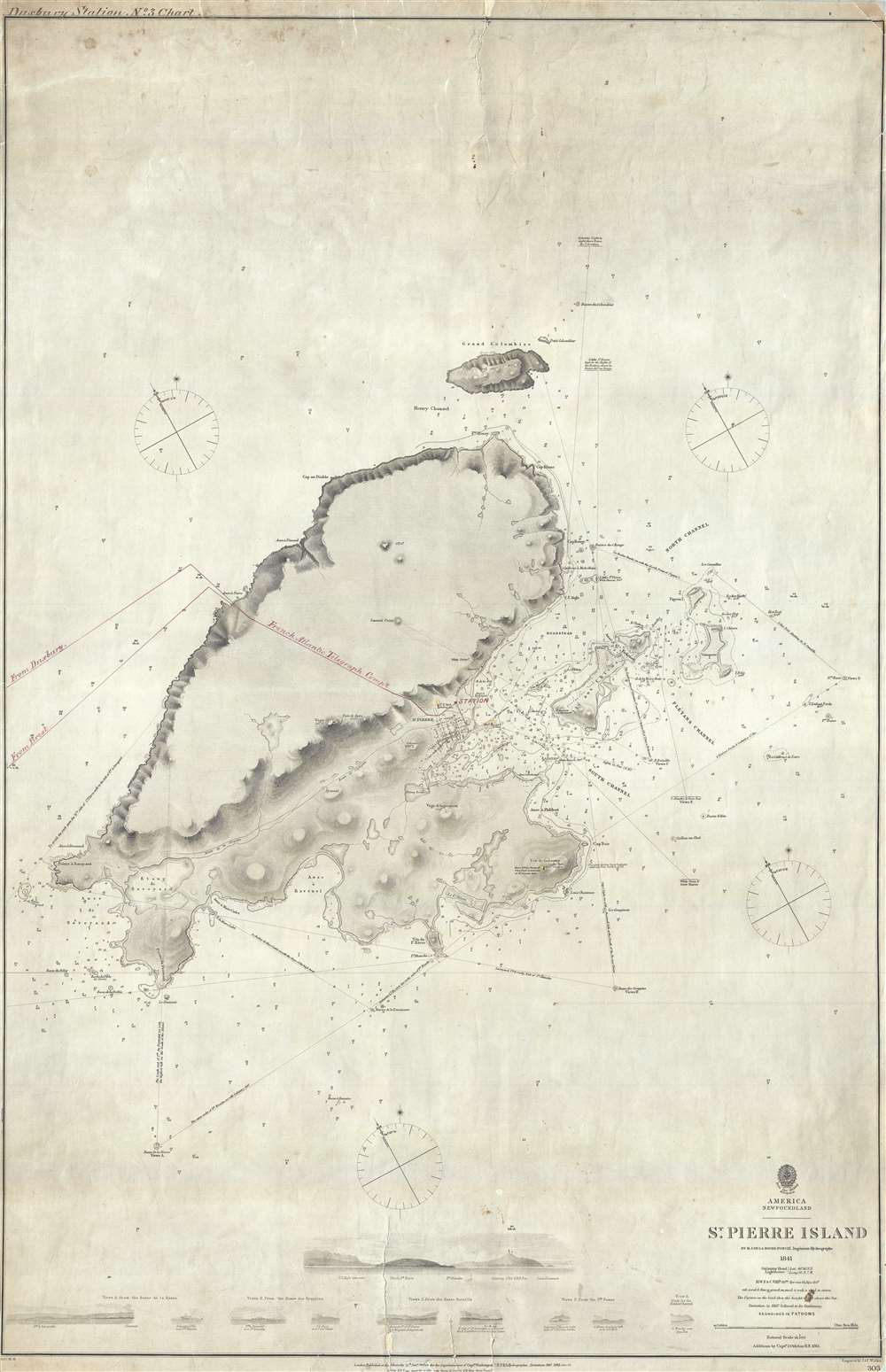
1865 Admiralty Chart of St Pierre Island (Miquelon) w/ TransAtlantic Cable
StPierre-admiralty-1861$750.00


Title
St. Pierre Island.
1861 (dated) 39 x 25 in (99.06 x 63.5 cm) 1 : 18200
1861 (dated) 39 x 25 in (99.06 x 63.5 cm) 1 : 18200
Description
A rare 1861 map of France's last colony in North America, the tiny island of St. Pierre of the coast of Newfoundland, with manuscript additions related to the French Atlantic Telegraph Company. This chart covers all of St. Pierre Island as well as the adjacent islands and the surrounding seas. The harbor community of St. Pierre is detailed with individual streets and buildings recognizable. This map is noteworthy not only for its rarity but also for the manuscript addition of the course of the French Atlantic Telegraph.
The French Atlantic Telegraph
French Atlantic Telegraph Company (La Société du Câble Transatlantique Française) was founded in 1869 with the objective of laying a transatlantic cable independent of British territories. The corporation defined a route from Brest, France, to the St. Pierre Island in the Miquelon Group, and then to Duxbury near Cape Cod. The completion of the French line, only the second such telecommunication line laid, undercut the British monopoly on transatlantic communication and dramatically changed the cable market. Given that this was the finest map of the region available when the telegraph was being laid, and that it bears manuscript notes relating to the telegraph, it is likely that this map was used in the telegraph's laying or management.Publication History
This map is based upon 1841 survey work completed by the French hydrographer Ferdinand Antoine Jules de la Roche-Poncié. It features various updates and revisions completed in 1861 by Captain J. Orlebar of the Royal Navy. The map was published by the British Admiralty and engraved in England by J. and C. Walker. Although there are references to this chart in various Admiralty chart catalogs from the 1860s through 1870s, we are aware of no other surviving examples.CartographerS
The British Admiralty Office (1795 - Present) or the United Kingdom Hydrographic Office refers to the Branch of the English government that is responsible for the command of the British Navy. In 1795 King George III created the United Kingdom Hydrographic Office, known in short as the U.K.H.O., to provide top notch nautical charts to the vast Royal Navy. Prior the founding of the Admiralty the surveying and creation of nautical charts was primarily a commercial venture wherein the cartographer himself, more of than not, actually financed the printing of his own material. The great navigator Cook himself is known to have scrambled for funds to publish his own seminal charts - the most important and advanced of the period. The system of privately funded nautical mapping and publishing left vast portions of the world uncharted and many excellent charts unpublished. King George III, responding significant loss in trade revenue related to shipwrecks and delay due to poor charts, recognized the need for an institutionalized government sponsored cartographic agency - the Admiralty. The first head of the Admiralty, a position known as Hydrographer, was the important cartographer Alexander Dalrymple. Dalrymple started by organizing and cataloging obtainable charts before initiating the laborious process of updating them and filling in the blanks. The first official Admiralty Chart appeared in 1800 and detailed Quiberon Bay in Brittany. By 1808 the position of Hydrographer fell to Captain Thomas Hurd. Hurd advocated the sale of Admiralty charts to the general public and, by the time he retired in 1829, had issued and published some 736 charts. Stewardship of the organization then passed to Rear Admiral Sir Francis Beaufort. It was under Beaufort's administration that the Admiralty truly developed as a "chart making" as opposed to a "chart cataloging" institution. Beaufort held his post from 1829 to 1854. In his 25 years at the Admiralty Beaufort created nearly 1500 new charts and sponsored countless surveying and scientific expeditions - including the 1831 to 1836 voyage of the H.M.S. Beagle. By 1855 the Admiralty's chart catalog listed some 1,981 charts. More by this mapmaker...
Ferdinand Antoine Jules de la Roche-Poncié (August 19, 1810 – March 30, 1881) was a French hydrographic engineer and cartographer active throughout the 19th century. Poncié was born in Vauxrenard, France. After graduating from the École Polytechnique in 1829 he joined the French navy, becoming a naval hydrographic engineer in 1832. Numerous important French surveys bear his name, including the first detailed hydrographic survey of the St. Pierre and Miquelon Islands, and numerous maps of East Asian waters. He received the Legion of Honor in 1841, ultimately attaining the grade of Commander. In 1860 he settled in Paris where he became a member of the Hydrographic Committee under Rear-Admiral Pierre Mathieu. He died in Paris in 1881. Learn More...
John Walker (1787 - April 19, 1873) was a British map seller, engraver, lithographer, hydrographer, geographer, draughtsman, and publisher active in London during the 19th century. Walker published both nautical charts and geographical maps. His nautical work is particularly distinguished as he was an official hydrographer for the British East India Company, a position, incidentally, also held by his father of the same name. Walker's maps, mostly published after 1827, were primarily produced with his brothers Charles Walker and Alexander Walker under the imprint J. and C. Walker. Among their joint projects are more than 200 maps for the influential Society for the Diffusion of Useful Knowledge Atlas (SDUK). In addition they published numerous charts for James Horsburgh and the British Admiralty Hydrographic Office, including Belcher's important map of Hong Kong and Carless' exploratory map of Karachi. The J. and C. Walker firm continued to publish after both Walkers died in the 1870s. Learn More...
Condition
Good. Several repaired tears. Soiling. Narrow margins.