1868 Admiralty Nautical Map or Chart of Russian Manchuria
StVladimirBay-admiralty-1868-2$150.00

Title
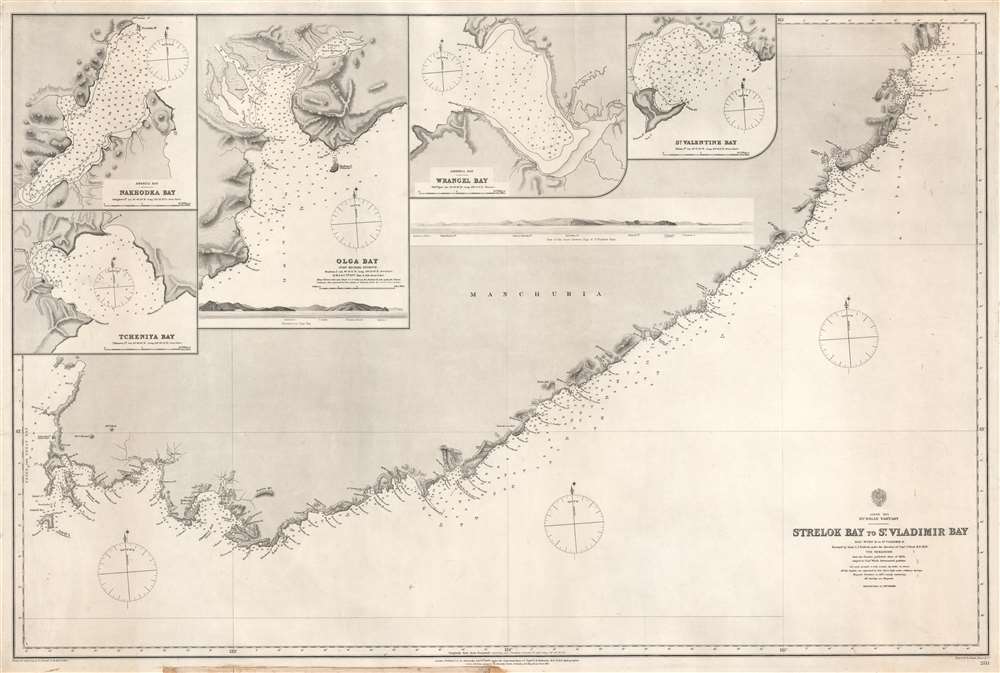
Strelok Bay to St. Vladimir Bay.
1868 (dated) 26.25 x 39 in (66.675 x 99.06 cm) 1 : 298000
1868 (dated) 26.25 x 39 in (66.675 x 99.06 cm) 1 : 298000
Description
This is a rare 1868 Admiralty nautical chart or maritime map of the Pacific coast of Russian Manchuria, just east of Valdivostok. The map is the result of detailed surveys conducted during the Second Opium War Second Opium War (1856 - 1860). The map depicts the coastline in great detail from Nakhodka to St. Vladimir Bay (Zaliv Vladimira). Numerous coastal locations are labeled including several points, islands, rivers, and smaller bays. Depth soundings are noted all along the coast, with the highest concentration around St. Vladimir Bay and America Bay. Four inset maps are situated in the upper left, depicting Tcheniya Bay, Nakhodka Bay, Olga Bay, and Wrangel Bay. Each of these inset maps include numerous depth soundings along with several identified locations. A profile view of the coastline between Olga Bay and St. Vladimir Bay is also illustrated.
Publication History and Census
This map was produced and published by the Admiralty in 1868 from surveys conducted by Lieutenant Charles James Bullock under the direction of Commander John Ward. Additional information was acquired by consulting a Russian chart published in 1863. An example is cataloged in OCLC and is part of the institutional collection at the British Library.CartographerS
The British Admiralty Office (1795 - Present) or the United Kingdom Hydrographic Office refers to the Branch of the English government that is responsible for the command of the British Navy. In 1795 King George III created the United Kingdom Hydrographic Office, known in short as the U.K.H.O., to provide top notch nautical charts to the vast Royal Navy. Prior the founding of the Admiralty the surveying and creation of nautical charts was primarily a commercial venture wherein the cartographer himself, more of than not, actually financed the printing of his own material. The great navigator Cook himself is known to have scrambled for funds to publish his own seminal charts - the most important and advanced of the period. The system of privately funded nautical mapping and publishing left vast portions of the world uncharted and many excellent charts unpublished. King George III, responding significant loss in trade revenue related to shipwrecks and delay due to poor charts, recognized the need for an institutionalized government sponsored cartographic agency - the Admiralty. The first head of the Admiralty, a position known as Hydrographer, was the important cartographer Alexander Dalrymple. Dalrymple started by organizing and cataloging obtainable charts before initiating the laborious process of updating them and filling in the blanks. The first official Admiralty Chart appeared in 1800 and detailed Quiberon Bay in Brittany. By 1808 the position of Hydrographer fell to Captain Thomas Hurd. Hurd advocated the sale of Admiralty charts to the general public and, by the time he retired in 1829, had issued and published some 736 charts. Stewardship of the organization then passed to Rear Admiral Sir Francis Beaufort. It was under Beaufort's administration that the Admiralty truly developed as a "chart making" as opposed to a "chart cataloging" institution. Beaufort held his post from 1829 to 1854. In his 25 years at the Admiralty Beaufort created nearly 1500 new charts and sponsored countless surveying and scientific expeditions - including the 1831 to 1836 voyage of the H.M.S. Beagle. By 1855 the Admiralty's chart catalog listed some 1,981 charts. More by this mapmaker...
John Ward (fl. c. 1840 - 1873) was a hydrographic survey officer of the British Royal Navy. Ward joined the Royal Navy in 1840. His first service was in the Bahamas and the West Indies. In 1848 he passed the naval officers exam and in 1850 was promoted to Lieutenant. From 1855 he worked on the Scotland coast completing a detailed survey under Captain H. C. Otter. In 1858, he was promoted to Commander assigned to the H.M.S. Actaon and sent to complete the survey of the China coast and the waters around Japan made during the Second Opium War (1856 - 1860). This position was initially held by Commander William Thornton Bate (January 31, 1818 - December 29, 1857), who was killed in the Second Opium War's Battle of Canton (1857). Bate's second, Lieutenant Chares Bullock (1826 - 1904), took interim command of the survey, to be replaced with Ward in 1858. From 1858 to 1861, Ward and Bullock completed meticulous surveys ranging from Hong Kong to Manchuria and from the Yangtze River to Japan. In 1864 he was promoted to command the Riflemen, but by 1866, returned to England having received an injury. He was nonetheless not retired from active service until 1873. Learn More...
Charles James Bullock (December 29, 1826 - October 1904) was a British Royal Navy Officer and marine surveyor. He was born in London, the son of Admiral Frederick Bullock (November 7, 1788 - February 6, 1874), also a well-regarded survey officer. From 1844 he served under Commander George Alexander Frazer (1786 - 1865), likely a relation through his wife Mary Louisa Frazer (1831 - 1804), with whom surveyed the east Irish coast. He was promoted to midshipman and Assistant-surveyor in 1846. From October of 1850 to June of 1854, he served as a midshipman under Senior Assistant-Surveyor Commander Captain William Thornton Bate (January 31, 1818 - December 29, 1857), who was assigned to hydrographic work in and around the Philippines. Bullock passed his officer's exam in 1853, and was promoted to Lieutenant on January, 1 1855. In 1856 he was reassigned to the Baltic, again under Frazer. From October of 1856, at the outbreak of the Second Opium War (1856 - 1860), Bullock was again sent to the China Sea, this time in command of the Dove a gunboat and tender to the H.M.S. Actaon. The H.M.S. Actaon was initially commanded by Captain W. Thornton Bate, then head of the China hydrographic Survey. Bate died in the Battle of Canton (1857), leaving Bullock, although just a Lieutenant, as interim commander of the survey. Bullock was replaced in 1858 by Commander John Ward and returned to the Dove. Working under Ward, Bullock completed surveys of the China coast throughout the course of the Second Opium War, from 1858 to 1861. After the war, in 1862, he returned to England, where he was assigned to the Hydrographic Office to assistant in compiling and publishing the China surveys. He was promoted to Commander in January of 1863. Bullock was given command of the H.M.S. Serpent in 1865 and again sent to Asia, where through 1869 he completed survey work in the Java Sea, in China, and around Japan. For his work, he was promoted to the rank of Post-Captain, in April of 1870. His heath having by this time began to decline, he retired from active duty on August 4, 1873. His brother, Augustus Thomas John Bullock (1828 - 1868) was also a survey officer. Learn More...
Condition
Very good. Soiling to lower margin but does not affect printed area. Closed margin tears professionally repaired on verso. Blank on verso.
References
OCLC 557654262.