This item has been sold, but you can get on the Waitlist to be notified if another example becomes available.
1790 Colles Survey of Roads - First American Road Book - Complete
SurveyofRoads-colles-1790$70,000.00

Title
A Survey of Roads of the United States of America by Christopher Colles.
1790 (dated) 9 x 6 in (22.86 x 15.24 cm) 1 : 110000
1790 (dated) 9 x 6 in (22.86 x 15.24 cm) 1 : 110000
Description
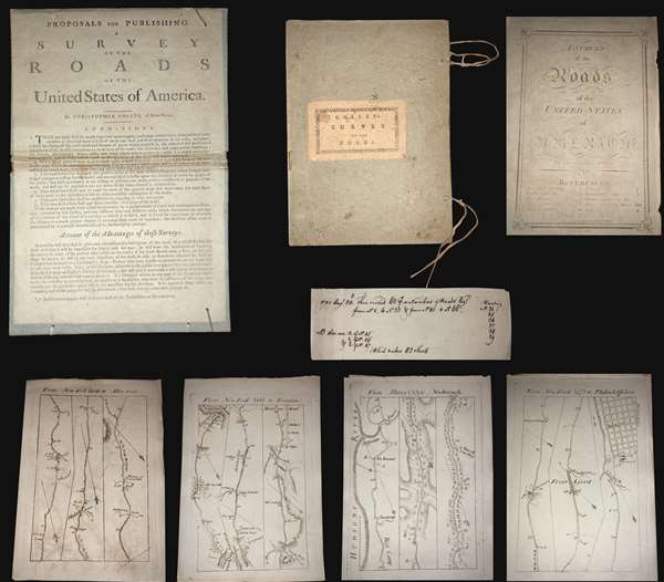
A superb example, entirely complete, of Christopher Colles' 1789 - 1790 A Survey of the Roads of the United States of America. This is the First American Road atlas, wherein at least some of the plates represent the first American maps engraved by a female - Colles' 13-year-old daughter Eliza. Covering depictions from Albany, New York to Williamsburg, Virginia, Colles' atlas consists of a prospectus, a title page, and 83 separate strip maps, each covering some 12 miles of roads and offering invaluable detail about the natural and human landscape of late 18th-century America and was published in commemoration of the founding of the new republic in 1789.
Bringing European Cartographic Ideas to America
The maps appear in a strip-map style previously unknown in North America, but common in European road maps, such as the 1720 Britannia Depicta, or Ogilby Improv'd. Colles' issued the work in separate sheets that could be mixed and matched in a modular format, as needed. This modular format was his own innovation and challenged the user to interpret American roads linearly, as only a traveler can (and must).
The atlas includes 83 separate sheet maps, numbered 1-33, 40-86, and 45*, 46* and 47*. The sheets are laid loose in their original portfolio, with Colles' pastedown title, the original ties and the prospectus pasted to the inside of the front board, as found in most examples. The title page bears the date 1789. It is important to note that it was believed, until recently, that the maps were issued in parts through 1792. However, a hand-written note, laid in by an early-though sadly unnamed-owner, demonstrates that the maps were in fact complete and delivered to subscribers by 1790.
A Federalist Document
In the words of historian Trish Loughran, writing in the The Republic in Print (page 236),
Colles originally intended to survey and map each and every road personally, and many of the maps are indeed based upon his own work. To accomplish this task Colles invented a new kind of perambulator - essentially a modified wagon wheel of a fixed circumference attached to counting cogs that could be used to record distances, a great improvement over the more traditional surveyor's chain. Colles found, however, that completion of the surveys was beyond his limited means, and so, relied upon existing work by military surveyors Simeon DeWitt and Robert Erskine for the maps of Maryland and Virginia. Ultimately, Colles never fully completed his atlas, with only 83 of the originally intended 100 maps published.
Engraved by Americas First Female Map Engraver - Eliza Colles
The maps were drafted by Colles, then engraved by Cornelius Tiebout, and later by his daughter Eliza Colles. It would seem that sometime in the middle of the engraving process, Colles had a falling out with Tiebout and recruited his 13-year-old daughter, Eliza, who may have been Tiebout's apprentice, to complete the engravings. Eliza thus became the first American female engraver. While there is no definitive proof that Eliza engraved for the Survey of Roads, many scholars note that the engraving style of the individual sheets does change, suggesting at least two different engravers were active. In particular the notion is supported by Walter Ristow (page 164) and Benson Lossing, who wrote in his History of New York,
A Financial Failure
Colles sold the maps found in his Survey of Roads by subscription, charging a quarter dollar up front, plus an eighth of a dollar for each delivered section of six sheets. (Nonsubscribers were charged 3 cents per sheet.) Despite a fair price (compare to Abraham Bradley's 1796 map of the United States at 3 1/2 - 5 dollars), accuracy, and fine workmanship, indeed ahead of its time, A Survey of the Roads of the United States of America floundered financially. The intended impact of the work; to promote travel, trade and real-estate transactions, failed to attract sufficient subscribers. As a result, the completed work was offered only in New York and Philadelphia. Deep in debt, Colles began to sell the completed sections of the work separately, with most buyers only acquiring those portions of the maps which they deemed most useful - thus the incompleteness of most known examples.
Incomplete copies are held by the American Antiquarian Society, American Geographical Society, British Library, Clements Library, Columbia, Connecticut Historical Society, Connecticut State Library, Library Company of Philadelphia, New Jersey Historical, New York Historical Society, New York Public Library, and Rutgers. The David Rumsey copy is also incomplete.
The present example was obtained from a private collection in upstate New York where it was acquired more than 25 years ago at an estate auction.
The Collation
Covering the United States from New York to Virginia, the collation is as follows;
Bringing European Cartographic Ideas to America
The maps appear in a strip-map style previously unknown in North America, but common in European road maps, such as the 1720 Britannia Depicta, or Ogilby Improv'd. Colles' issued the work in separate sheets that could be mixed and matched in a modular format, as needed. This modular format was his own innovation and challenged the user to interpret American roads linearly, as only a traveler can (and must).
The atlas includes 83 separate sheet maps, numbered 1-33, 40-86, and 45*, 46* and 47*. The sheets are laid loose in their original portfolio, with Colles' pastedown title, the original ties and the prospectus pasted to the inside of the front board, as found in most examples. The title page bears the date 1789. It is important to note that it was believed, until recently, that the maps were issued in parts through 1792. However, a hand-written note, laid in by an early-though sadly unnamed-owner, demonstrates that the maps were in fact complete and delivered to subscribers by 1790.
A Federalist Document
In the words of historian Trish Loughran, writing in the The Republic in Print (page 236),
Colles placed the year 1789 on the title page in order to make the book's publication coincide with the ratification of the Constitution and the formation of the new government. Indeed, Colles even goes so far as to begin the book's fictional journey on Plate 1 at New York's Federal Hall, which was in 1789, the new national capitol and the recent site of Washington's inauguration. In this way, the book makes the continual literal and symbolic reference to the newly invented nation-state even as it attempts to collect and contain a map to every known space within it in the highly singular space of a book. That it does so in such a way that each represented space can also be experienced locally, by the body hold up any given map on any given road, makes this an exceptional artifact in the production of federalist space.The Work of a Mad Tinkerer
Colles originally intended to survey and map each and every road personally, and many of the maps are indeed based upon his own work. To accomplish this task Colles invented a new kind of perambulator - essentially a modified wagon wheel of a fixed circumference attached to counting cogs that could be used to record distances, a great improvement over the more traditional surveyor's chain. Colles found, however, that completion of the surveys was beyond his limited means, and so, relied upon existing work by military surveyors Simeon DeWitt and Robert Erskine for the maps of Maryland and Virginia. Ultimately, Colles never fully completed his atlas, with only 83 of the originally intended 100 maps published.
Engraved by Americas First Female Map Engraver - Eliza Colles
The maps were drafted by Colles, then engraved by Cornelius Tiebout, and later by his daughter Eliza Colles. It would seem that sometime in the middle of the engraving process, Colles had a falling out with Tiebout and recruited his 13-year-old daughter, Eliza, who may have been Tiebout's apprentice, to complete the engravings. Eliza thus became the first American female engraver. While there is no definitive proof that Eliza engraved for the Survey of Roads, many scholars note that the engraving style of the individual sheets does change, suggesting at least two different engravers were active. In particular the notion is supported by Walter Ristow (page 164) and Benson Lossing, who wrote in his History of New York,
Colles constructed and published a series of sectional road maps which were engraved by his daughter.It should be underlined that Eliza also engraved another of Colles' extremely rare but monumental Geographical Ledger, which appeared in 1794 shortly after the Survey of Roads and bears Eliza's imprint.
A Financial Failure
Colles sold the maps found in his Survey of Roads by subscription, charging a quarter dollar up front, plus an eighth of a dollar for each delivered section of six sheets. (Nonsubscribers were charged 3 cents per sheet.) Despite a fair price (compare to Abraham Bradley's 1796 map of the United States at 3 1/2 - 5 dollars), accuracy, and fine workmanship, indeed ahead of its time, A Survey of the Roads of the United States of America floundered financially. The intended impact of the work; to promote travel, trade and real-estate transactions, failed to attract sufficient subscribers. As a result, the completed work was offered only in New York and Philadelphia. Deep in debt, Colles began to sell the completed sections of the work separately, with most buyers only acquiring those portions of the maps which they deemed most useful - thus the incompleteness of most known examples.
Census and Provenance
Today, examples of A Survey of the Roads of the United States of America, are exceedingly rare. Historian Walter Ristow, who composed a work on the road book, estimated that only between 30 and 35 complete examples are known to exist, but this number needs revision in the light of our own research. Complete copies are known at the Boston Athenaeum, Dartmouth, Harvard, Huntington Library, John Carter Brown Library, Library of Congress (2), New York Historical Society (2), New York Public Library, New York State Library (2), Pennsylvania Historical Society, University of Virginia, Williams College, and Yale.Incomplete copies are held by the American Antiquarian Society, American Geographical Society, British Library, Clements Library, Columbia, Connecticut Historical Society, Connecticut State Library, Library Company of Philadelphia, New Jersey Historical, New York Historical Society, New York Public Library, and Rutgers. The David Rumsey copy is also incomplete.
The present example was obtained from a private collection in upstate New York where it was acquired more than 25 years ago at an estate auction.
The Collation
Covering the United States from New York to Virginia, the collation is as follows;
Covers and Prospectus Title page 7-Jan New York to Stratford 13-Aug New York to Poughkeepsie 14 Poughkeepsie - Albany 15 - 20 Stratford to Poughkeepsie 21 - 25 Poughkeepsie - Albany 26 - 33 Albany to Newborough 34 - 39 Never published, lacking in all known copies 40 New York to Elizabeth town 41 - 42 New York to Brunswick 43 New York to Kingston 44 New York to Trenton 45 New York to Bristol 45* New York to Cranberry 46 New York to Frankford 46* New York to Allentown 47 New York to Philadelphia 47* New York to Blackhorse 48 New York to Mount Holly 49 - 50 New York to Philadelphia 51 - 60 New York to Annapolis 62 - 63 Annapolis to Bladensburg 64 - 65 Annapolis to Alexandria 66 Annapolis to Dumfries 67 - 68 Annapolis to Fredericksburg 69 Annapolis to Tod's Ordinary 70 Annapolis to Bowling-green Ord* 71 Annapolis to Head Lynch's Ord* 72 Annapolis to Hanover Courthouse 73 Annapolis to Hanover and New Castle 74 - 75 Annapolis to New Kent Court-house 76 - 77 Annapolis to Williamsburgh 78 - 79 Annapolis to York 80 - 81 Williamsburgh to Aylett's Warehouse 82 Williamsburgh to Sneed's Ordinary 83 - 84 Williamsburgh to Port-Royal 85 - 86 Williamsburgh to Hooe's Ferry
CartographerS
Christopher Colles (May 9, 1739 - 1816) was an Irish-born American polymath, civil engineer, inventor, and publisher active in New York during the late British Colonial, Revolutionary War, and post-Revolutionary War periods. Colles was born in Ireland where as young man, he proved adept at mathematics and mechanics under the patronage of his uncle, William Colles, and the tutelage of Rochart Pococke, an English clergyman and anthropologist. His first mapping projects included 1777 surveys of Limerick, which were later collated and compiled into a published map. When his uncle/patron William Colles died, in 1771, Colles emigrated to Philadelphia where he attempted to established himself as an engineer. Failing to draw clients to his grandiose visions, he instead turned to lecturing, advertising courses on hydraulics, mechanics, hydrostatics, pneumatics, and geography, among others. Shortly before the outbreak of the American Revolutionary War (1775 - 1783), Colles relocated to New York City, where he convinced the Municipal Council to fund an ambitious water management and distribution project. By the time the British invaded New York, in 1776, the project was well underway, but was sadly demolished by the invading army. Sympathizing with the Continental cause, Colles fled the British controlled city, first to New Jersey, then to Kingston New York, and possibly as far as Albany. Following the war, he petitioned George Washington and the New York State legislature for funds to complete major waterway projects in the Ohio River and Mohawk River Valleys. Both projects, failing to secure funding, were abandoned. From 1789 - 1790, Colles published one of his most significant works, A Survey of the Roads of the United States, detailing, two or three maps to a sheet, American roads from New England to Virginia. This important project was the first comprehensive road atlas published in the United States. While A Survey of Roads of the United States is a seminal work of great historical significance, it was financial failure. Over the subsequent years, Colles continued to propose high-minded civil engineering projects, ranging from a proto 'Erie Canal' to a raised New Jersey 'Timber Canal.' During the War of 1812, Colles worked in the New York optical telegraph office, only the second to have been established in the United States. He was also a commissioned captain of the New York Militia. As he grew older, Colles' careers floundered and he fell into a state of extreme poverty, ultimately taking work as the janitor of an alms house. He died shortly thereafter. In describing the Geographical Ledger, one of Colles' great unpublished works, the historian Trish Longhran, gives us a great understanding of the genius's character and tragic life marked by ambition and failure:
The Geographical Ledger went the way of all of Colles' projects: it failed because it lacked subscribers, because Colles did not have the resources to produce it on the terms he had proposed, and because it was, in short, materially unfeasible for an impoverished New York tinkerer to produce a map of the world that recorded and cross-referenced every imaginable everything. (Longhran, T., The Republic in Print, page 298)Christopher Colles was buried at St. Paul's, in New York City, in an unmarked grave, a remarkable man driven by a vision and genius, that, ahead of its time, was also his downfall. Colles was survived by his wife Anee Keough Colles and their surviving children, including his daughter, Eliza [Elizabeth] Colles (1775 - 1799), who engraved many of his maps becoming, as such, America's first female map engraver. More by this mapmaker...
Elizabeth Colles (1775 - 1799) or Eliza, was an American engraver of Irish descent, the daughter of visionary inventory and mapmaker, Christopher Colles. She was the first American female map engraver. Working for her father, Eliza engraved many of the plates for A Survey of the Roads of the United States, the first American road book, and the unpublished/unfinished Geographical Ledger (New York plate, Canada/Vermont Plate, and the two diagrams in the index). Eliza was probably taught engraving by either her father or Cornelius Tiebout, and appears to have become involved with the Colles Survey of Roads at just 13 years of age, when her father, Christopher Colles, had a falling out with Tiebout. Her name is often represented as Eliza Coles. Elizabeth died at 23 or 24, probably in the 1799 Yellow Fever Epidemic. Learn More...
Cornelius Tiebout (c. 1760 - February 1832) was an American engraver of portraits and maps, possibly the first American-born engraver. He is credited with engraving most of the maps for Christopher Colles' 1789-1790 A Survey of the Roads of the United States of America and for introducing English stippled portraiture to America. Tiebout was born to Tunis Tiebout and Elizbeth Lamb in New York City. They were an hold Huguenot family with lands on the Delaware River as early as 1656. He was initially apprenticed as a silversmith under John Burger (1747 - 1828), but began engraving on copper to make extra money. His imprint appears alongside that of Burger on a collection of psalm tunes from about 1780-1785 - suggesting this is apprentice work. Apprenticeships ran from about 14 - 21, and his master adding his name to the imprint suggesting a late apprenticeship stage, meaning he was likely born about 1766 - 1765. Most references regarding his birth place it around 1773 - 1777, but this latter range seems a stretch. As early as 1789 he was working with Christopher Colles on various projects including A Survey of the Roads of the United States of America. In 1790, Tiebout had a falling out with Colles, abandoned the incomplete road book project, and took work engraving for New York Magazine and Brown' Family Bible. Early in 1793, Tiebout traveled to London where he studied English stipple engraving under James Heath. Returning to New York in 1796, he completed a stipple engraving of John Jay, the first strong example of that style by an American, establishing his reputation as a portraitist. Tiebout remained as an engraver in New York until 1799, after which he relocated to Philadelphia where he achieved some success selling portrait prints, becoming in the process wealthy. In a turn-around, in 1825 most of his riches were lost in a failed business venture of uncertain aspect. Shortly after his financial collapse, Tiebout relocated to New Harmony, Indiana, where he founded a free school of printing and engraving with industrialist William Maclure. He died in February of 1832. Tiebout maintained offices in New York at 24 Golden Hill and 273 Pearl Street. Learn More...
Condition
Very good. Complete. Original boards, original ties. Letterpress Prospectus pasted down on inside of boards, as in most examples. Maps are loose. Some maps exhibit foxing and toning and there is some variance in the paper, as per all examples. 'Beekman' added in ink to sheet 1, and laid in is a slip of laid paper bearing ink notations dated Aug. 30, 1790.
References
ESTC #W22401. Evans, American Bibliography, #21741. Phillips, Atlases, #1326. Sabin, J., A Dictionary of Books Relating to America: from its Discovery to the Present Time, #14411. Rumsey #2467 (incomplete). Streeter #3936. Much background from Ristow, American Maps and Mapmakers, pp. 158-166. Wheat & Brun: Maps And Charts Published In America Before 1800, R.97 (with each map sheet also assigned its own entry).