This item has been sold, but you can get on the Waitlist to be notified if another example becomes available, or purchase a digital scan.
1732 Homann Heirs Map of Switzerland
Switzerland-homann-1732$175.00

Title
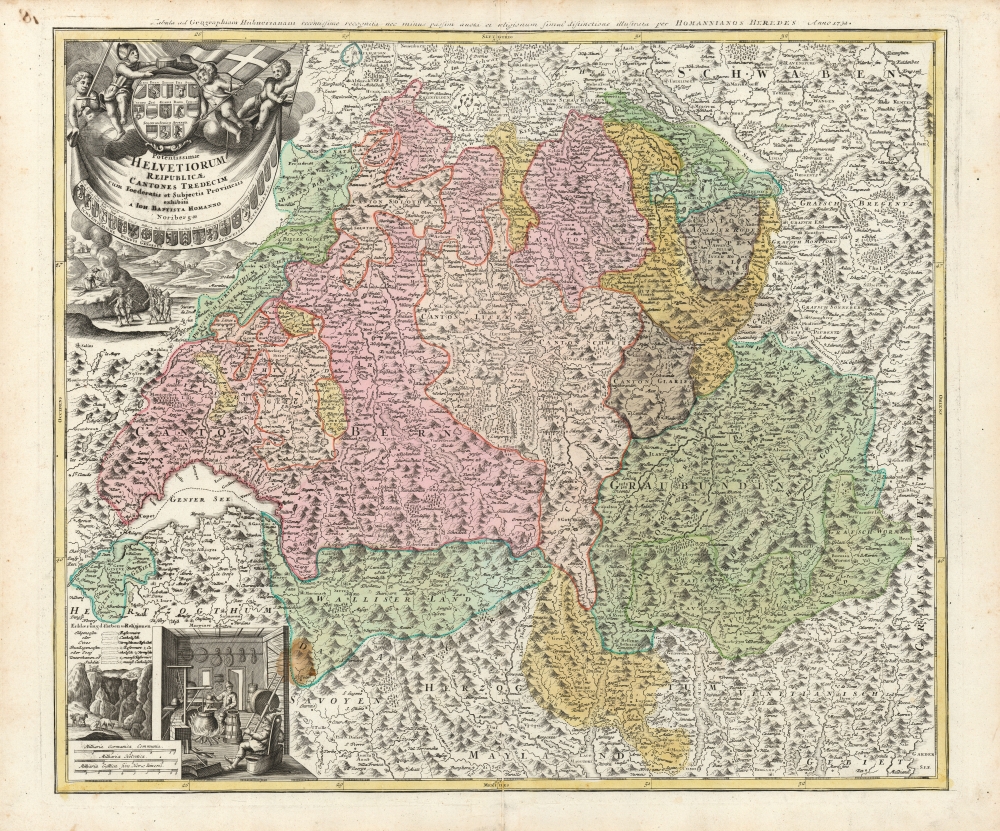
Potentissime Helvetiorum Reipublicae Cantones Tredecium cum Foederatis edt Subjectis Provinciis exhibiti a Joh. Baptista Homanno Noribergae.
1732 (undated) 19 x 22 in (48.26 x 55.88 cm) 1 : 580000
1732 (undated) 19 x 22 in (48.26 x 55.88 cm) 1 : 580000
Description
This is Johann Baptist Homann's map of Switzerland divided into its thirteen cantons, in an example printed by Homann Heirs for inclusion in Hübner's popular school atlas starting in 1732. It is an evocative map, with the alpine landscape indicated pictorially in profile.
A Closer Look
The map is beautifully engraved, with a baroque, martial cartouche surmounted with putti brandishing weapons. The cartouche is further embellished with the arms of Switzerland's cantons, primary cities, and municipalities. Below the cartouche, soldiers march through a mountainous landscape, drawn by signal fires lit on the mountaintops. In the lower left are two characteristically Swiss vignettes: cows graze in a valley between alpine cliffs, while cattleherds guide their bovine charges atop ludicrously precarious peaks. To the right of this scene is depicted the workings of a Swiss cheese dairy. Not for nothing were the Swiss famous for their cheese: not only was it the principal food of the country, but it also was used as currency.Publication History and Census
This map was first engraved for inclusion in Homann's atlases; the earliest example we see was bound in a 1712 edition of Homann's Atlas Novus Terrarum Orbis Imperia Regna. After Homann's death, his heirs continued to use the map in their variously-titled school atlas, intended to accompany Johann Hübner's geographical course. As is often the case with the Homann Heirs maps, we see examples of the map printed from no fewer than two plates, with these showing multiple changes. None of these, to our knowledge, have been given a comprehensive bibliography. We identify two different plates with an engraved date of 1732 in the upper margin, such as the present example. Maps with this date are well represented in institutional collections, but it is not at all clear when the various plates were actually printed.CartographerS
Johann Baptist Homann (March 20, 1664 - July 1, 1724) was the most prominent and prolific map publisher of the 18th century. Homann was born in Oberkammlach, a small town near Kammlach, Bavaria, Germany. As a young man, Homann studied in a Jesuit school and nursed ambitions of becoming a Dominican priest. Nonetheless, he converted to Protestantism in 1687, when he was 23. It is not clear where he mastered engraving, but we believe it may have been in Amsterdam. Homann's earliest work we have identified is about 1689, and already exhibits a high degree of mastery. Around 1691, Homann moved to Nuremberg and registered as a notary. By this time, he was already making maps, and very good ones at that. He produced a map of the environs of Nürnberg in 1691/92, which suggests he was already a master engraver. Around 1693, Homann briefly relocated to Vienna, where he lived and studied printing and copper plate engraving until 1695. Until 1702, he worked in Nuremberg in the map trade under Jacob von Sandrart (1630 - 1708) and then David Funck (1642 - 1709). Afterward, he returned to Nuremberg, where, in 1702, he founded the commercial publishing firm that would bear his name. In the next five years, Homann produced hundreds of maps and developed a distinctive style characterized by heavy, detailed engraving, elaborate allegorical cartouche work, and vivid hand color. Due to the lower cost of printing in Germany, the Homann firm could undercut the dominant French and Dutch publishing houses while matching their diversity and quality. Despite copious output, Homann did not release his first major atlas until the 33-map Neuer Atlas of 1707, followed by a 60-map edition of 1710. By 1715, Homann's rising star caught the attention of the Holy Roman Emperor Charles VI, who appointed him Imperial Cartographer. In the same year, he was also appointed a member of the Royal Academy of Sciences in Berlin. Homann's prestigious title came with several significant advantages, including access to the most up-to-date cartographic information as well as the 'Privilege'. The Privilege was a type of early copyright offered to very few by the Holy Roman Emperor. Though less sophisticated than modern copyright legislation, the Privilege offered limited protection for several years. Most all J. B. Homann maps printed between 1715 and 1730 bear the inscription 'Cum Priviligio' or some variation. Following Homann's death in 1724, the firm's map plates and management passed to his son, Johann Christoph Homann (1703 - 1730). J. C. Homann, perhaps realizing that he would not long survive his father, stipulated in his will that the company would be inherited by his two head managers, Johann Georg Ebersberger (1695 - 1760) and Johann Michael Franz (1700 - 1761), and that it would publish only under the name 'Homann Heirs'. This designation, in various forms (Homannsche Heirs, Heritiers de Homann, Lat Homannianos Herod, Homannschen Erben, etc.) appears on maps from about 1731 onwards. The firm continued to publish maps in ever-diminishing quantities until the death of its last owner, Christoph Franz Fembo (1781 - 1848). More by this mapmaker...
Homann Heirs (1730 - 1848) were a map publishing house based in Nuremberg, Germany, in the middle to late 18th century. After the great mapmaker Johann Baptist Homann's (1664 - 1724) death, management of the firm passed to his son Johann Christoph Homann (1703 - 1730). J. C. Homann, perhaps realizing that he would not long survive his father, stipulated in his will that the company would be inherited by his two head managers, Johann Georg Ebersberger (1695 - 1760) and Johann Michael Franz (1700 - 1761), and that it would publish only under the name 'Homann Heirs'. This designation, in various forms (Homannsche Heirs, Heritiers de Homann, Lat Homannianos Herod, Homannschen Erben, etc..) appears on maps from about 1731 onwards. The firm continued to publish maps in ever diminishing quantities until the death of its last owner, Christoph Franz Fembo (1781 - 1848). Learn More...
Source
Homann, J. B., Neuer Atlas bestehend in einig curieusen Astronomischen Kuppren und vielen auserlesenen accuratensten Land-Charten über die Gantze Welt, (Nuremberg: Homann), 1716.
Homann's Neuer Atlas bestehend in einig curieusen Astronomischen Kuppren und vielen auserlesenen accuratensten Land-Charten über die Gantze Welt was first publihsed in 1707 with 33 maps. A second edition followed in 1710 with 60 maps. Subsequent editions followed until about 1730. The title page notes proudly that the atlas features measurements based on the 'Copernican principle of the moving sky', a truly state-of-the-art innovation for the period. Regardless of editions, collations of the atlas are inconsistent, with some examples having less, while others have more maps - a consequence of the fact that the map sheets were delivered loose, to be bound at the buyer's discretion, and so some buyers chose to omit maps they did not consider relevant, or add others they did. Between editions, the constituent maps, particularly of European regions, were regularly updated to reflect the most recent political events. The atlas continued to be published by Homann's son, J. C. Homann (1703 - 1730), and then by Homann Heirs. Most examples also feature a fine allegorical frontispiece with the title Atlas Novus Terrarum Orbis Imperia, regna et Status, which was used for multiple Homann atlases, including the Neuer Atlas and the Atlas Minor.
Condition
Good. Small visible stain, some printers' smudging. Else very good with original outline and wash color.
References
OCLC 60345235. Rumsey 12499.081 (1716).