
1925 Map of North Sydney and Mosman, Australia

North Sydney / Mosman.
Development of the Lower North Shore.
$350.00
Choose a Collection:
- Digital Map Information
- Suitable for large format printing
- Full resolution TIFF file
- ICC color profile embedded
- Delivered instantly via download link
This Item
Enquire
Development of the Lower North Shore.
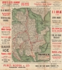
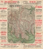
This is a fascinating c. 1925 double-sided map of Mosman and North Sydney, capturing Sydney's Lower North Shore in the midst of dramatic suburban transformation. Dense networks of trams, ferries, railways, new roads, real-estate development, and automobile advertising document communities expanding rapidly across the harbor from central Sydney. Most significantly, the North Sydney map marks the future Sydney Harbour Bridge as the 'North Shore Bridge' and 'under construction,' recording the monumental infrastructure project that both responded to this growth and would soon accelerate it.A Closer Look
One side details Mosman, tracing its roads, tramways, ferry routes, parks, military lands, and other features, including Taronga Zoological Park. The reverse maps North Sydney, where an especially dense tram network converges with the North Shore railway line and the ferry connections linking the suburb to central Sydney. By this period, Sydney possessed one of the world's great urban tram systems, essential to the development of suburbs beyond the older metropolitan core.Dominating the historical context of the North Sydney map is the Sydney Harbour Bridge, identified here by the earlier name 'North Shore Bridge' and explicitly marked as 'under construction.' The bridge was among Australia's most ambitious engineering projects and would fundamentally reshape movement between Sydney and the North Shore after its opening in 1932. Its appearance here places the map at a particularly evocative moment: the Lower North Shore was already flourishing, but the structure that would permanently transform its connection to the city had not yet been completed.
Both maps are enclosed by lettered reference grids and surrounded by commercial advertisements, particularly for automobiles and real estate. These are more than incidental decoration. Together with the transportation networks filling the maps, they evoke the forces reshaping suburban Sydney during the 1920s: population growth, property development, increasing mobility, and the gradual rise of the automobile alongside established tram, rail, and ferry systems.
Publication History and Census
An unidentified publisher produced this map around 1925. Although undated, its depiction of the Sydney Harbour Bridge as under construction places it after work commenced in 1923 and before the bridge opened in 1932, while other details suggest a date near the middle of that period. References to additional sheets, including 'See Map City of Sydney,' indicate that it likely belonged to a larger series of metropolitan maps - none of which we have been able to identify.As for this map, we see no other examples in either institutional collections or on the marketCondition
Good. Wear and soiling along fold lines.