
1561 Ruscelli/ Ptolemy Map of the British Isles

This item has been sold.
Tabula Europae I.
Mapping the Northern Limits of the Roman Empire.
- Digital Map Information
- Suitable for large format printing
- Full resolution TIFF file
- ICC color profile embedded
- Delivered instantly via download link
Mapping the Northern Limits of the Roman Empire.
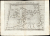
This is a handsome example of Girolamo Ruscelli's 1561 Ptolemaic map of the British Isles. The map captures the northwest limits of what Ancient Rome knew of the world, reflecting Julius Caesar and Claudius' invasions of England.A Closer Look
The map, presented on Ptolemy's trapezoidal projection, spans from the northern coasts of Roman Gaul and Germany in the south to the legendary island of Thule (Thyle) at 63° north; it centers the islands of Ireland (Ibernia), England, and Scotland (Albion). Both Ireland and Scotland exhibit a pronounced eastward bend, characteristic of Ptolemy's mapping of the Isles. England and Wales are somewhat more accurate, and the Bristol Channel is identifiable. Topography is indicated pictorially with rivers named. Towns are not marked, although tribal regions are. The Orkney Islands appear north of Scotland; an array of islands in the Irish Sea includes Mona (Isle of Man). The surrounding oceans are neatly stippled.Developing Cartography of the British Isles
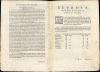
The inaccuracies of Ptolemy's map - particularly the drastic errors in mapping Scotland - have long inspired comment and are the subject of continuing debate. In the Roman era, this region represented the northwestern extremity of the known habitable world. The scientific survey had not yet been developed, and the systematic use of astronomical triangulation was not widespread. Ptolemy's knowledge was pieced together from several sources. His most accurate, contemporary data derived from Roman military itineraries as related by Marinus of Tyre (c. CE 70 - 130). Distances were typically determined by travel time or dead reckoning. For regions that had not yet been reached by Roman conquest, Ptolemy had to rely on the reports of the ancient Greek geographer Eratosthenes (c. 276 - c. 194 BCE ) and the Roman Strabo (135 - 87 BCE). Thule holds its place in the utmost north limit of Ptolemy's oikoumene, which follows Eratosthenes' model. Ptolemy's placement of the tip of Scotland farther south is interpreted by some scholars as consistent with that, and by others as an arbitrary choice to maintain Thule's place as the northernmost feature of the oikoumene, bending Scotland to make it 'fit.'While the specific reasons for Ptolemy's distortion of Scotland remain a puzzle, the basic issue appears to hold: that while he had minimal data for Scotland and Ireland, his data for the southern part of the British Isles was better, being based on Roman reports from the invasions of Julius Caesar (BCE 55 and 54) and Claudius (43 CE). While towns are not named on the map, a table on the verso gives the positions of London and York. The map names rivers and promontories, the forests of Vidogara and Caledonia in Scotland, and several of the Britannic tribes (identified by Caesar).
Ancient Cartography Revisited
Ruscelli's La Geografia di Claudio Tolomeo Alessandrino was firstly a definitive edition of Ptolemy's ancient geographical text, and so Ruscelli's 16th-century maps shared a binding with maps like this one, which reflected 2nd-century geographical knowledge. Ruscelli was not the only late Renaissance geographer to publish Ptolemy's work. The ancient maps in this edition were derived from Giacomo Gastaldi's 1548 works, which in turn were derived from Sebastian Münster's 1540 work.Publication History and Census
Giulio Sanuto engraved this map for inclusion in Ruscelli's 1561 La Geografia di Claudio Tolomeo Alessandrino, and the plate appeared in all editions of that work. The separate map is cataloged in just 4 institutional collections, although it occasionally appears on the market. The maps of the 1561 edition were engraved two to a plate; consequently, the platemark extends beyond the upper edge of the sheet in the 1561, 1562, and 1564 printings. Afterward, the plates were divided, and examples from 1574 onward exhibit a platemark surrounding the map; furthermore, the plates show considerable evidence of reworking, in many cases simplifying mountain forms to improve clarity. In 1599, letterpress was added to the upper border, along with decorative engraving in water areas. The present example conforms typographically to the 1561 first edition.Cartographers
Girolamo Ruscelli (1500 - 1566) was an Italian polymath, humanist, editor, and cartographer active in Venice during the early 16th century. His work as a polygraph - a writer on many subjects, producing, editing, and copying content for the new printing industry - required erudition in a broad array of fields. Born in Viterbo, Ruscelli lived in Aquileia, Padua, Rome, and Naples before relocating to Venice, where he spent much of his life. Cartographically, Ruscelli is best known for his important revision of Ptolemy's Geographia, which he published in 1561, with further editions as late as 1599. Ruscelli's work represented a marked improvement on Gastaldi's 1548 Ptolemy, presenting both the ancient and modern maps in larger, more clearly-engraved examples. His edition also included maps not present in Gastaldi's Ptolemy, including the first double-hemisphere world map to appear in a Geography, the earliest mapping of the British Isles from an English source, and the notorious and influential Zeno map of the North Atlantic. Ruscelli is also listed as the editor of such important works as Boccaccio's Decameron, Petrarch's verse, Ariosto's Orlando Furioso, and various other works. In addition to his well-known cartographic work, many scholars associate Ruscelli with Alexius Pedemontanus, author of the popular De' Secreti del R. D. Alessio Piemontese. This well-known work, or "Book of Secrets," was a compilation of scientific and quasi-scientific medical recipes, household advice, and technical commentary on a range of topics that included metallurgy, alchemy, dyeing, and perfume making. Ruscelli, as Alexius, founded an "Academy of Secrets," a group of noblemen and humanists dedicated to unearthing "forbidden" scientific knowledge. This was the first known experimental scientific society and was later imitated by a number of other groups throughout Europe, including the Accademia dei Secreti of Naples. Further Details...
Claudius Ptolemy (83 - 161 AD) is considered to be the father of cartography. A native of Alexandria living at the height of the Roman Empire, Ptolemy was renowned as a student of Astronomy and Geography. His work as an astronomer, as published in his Almagest, held considerable influence over western thought until Isaac Newton. His cartographic influence remains to this day. Ptolemy was the first to introduce projection techniques and to publish an atlas, the Geographiae. Ptolemy based his geographical and historical information on the "Geographiae" of Strabo, the cartographic materials assembled by Marinus of Tyre, and contemporary accounts provided by the many traders and navigators passing through Alexandria. Ptolemy's Geographiae was a groundbreaking achievement far in advance of any known pre-existent cartography, not for any accuracy in its data, but in his method. His projection of a conic portion of the globe on a grid, and his meticulous tabulation of the known cities and geographical features of his world, allowed scholars for the first time to produce a mathematical model of the world's surface. In this, Ptolemy's work provided the foundation for all mapmaking to follow. His errors in the estimation of the size of the globe (more than twenty percent too small) resulted in Columbus's fateful expedition to India in 1492.
Ptolemy's text was lost to Western Europe in the middle ages, but survived in the Arab world and was passed along to the Greek world. Although the original text almost certainly did not include maps, the instructions contained in the text of Ptolemy's Geographiae allowed the execution of such maps. When vellum and paper books became available, manuscript examples of Ptolemy began to include maps. The earliest known manuscript Geographias survive from the fourteenth century; of Ptolemies that have come down to us today are based upon the manuscript editions produced in the mid 15th century by Donnus Nicolaus Germanus, who provided the basis for all but one of the printed fifteenth century editions of the work.
Further Details...
Giulio Sanuto (fl. 1540 – 1580) was a Venetian engraver. He was born the illegitimate son of Cavaliere Francesco di Angelo Sanuto; With his brother, the cartographer and scientific instrument maker Livio Sanuto (1520 – 1576) he produced an array of some of the most important geographical works produced in Venice during the second half of the sixteenth century. These included a 27-inch globe and the 1588 12-sheet atlas, Geografia della Africa. Giulio's career is singluar among Venice's engraves in that it appears to have been equally based on artistic, figurative work as well as his cartographic works. Giulio is more broadly known for a small but sought-after selection of decorative engravings; no more than twelve of these can be attributed confidently to him, including the monumental Apollo and Marsyas, measuring over 1.30 meters wide. Whilst Sanuto's engravings were generally based upon the designs of other artists, his work was both ambitious and grand, and he often signed these works. Further Details...
Source
Ruscelli, G., La Geografia di Claudio Tolomeo Alessandrino…, (Venice: Valgrisi) 1561.
Beginning in 1561, Girolamo Ruscelli published this important, expanded edition of Giacomo Gastaldi's 1548 Ptolemy. Its maps, engraved in Venice by Giulio Sanuto, were in the main based directly upon those in Gastaldi's 1548 work. The maps were larger format than Gastaldi's, however, and Sanuto's engraving was far clearer and more legible than those appearing in the 1548 work. There are some important additions that distinguish Ruscell's Ptolemy from Gastaldi's. Ruscelli's work contained a map of the habitable world according to Ptolemy, which the Gastaldi lacked; also, the double-hemisphere map appearing in the Ruscelli was new and did not appear in the Gastaldi. Ruscelli's modern map of England was based on the work of George Lily, rather than on the Waldseemüller-derived map appearing in the Gastaldi; the Ruscelli map is the earliest generally available map of England based on firsthand knowledge. In a fateful innovation, Ruscelli's work included Septentrionalium partium nova tabula,the first copy of Nicolo Zeno's 1558 fraud Carta da Navegar, which introduced a novel mapping of the northern parts of the world, including the phantom islands of Frisland, Icaria, Drogeo, and Estotiland. Had Ruscelli not copied the Zeno, which had a narrow, brief publication, this preposterous geography would have probably not taken hold. Its inclusion in Ruscelli's beautiful, authoritative, and popular work would lead to the adoption of the Zeno map by Mercator, Ortelius, Plancius, and their successors, baffling scholars for centuries. Ruscelli's Ptolemy had a long publication history, cementing the influence of the work. It appeared both in Italian and Latin editions, all printed in Venice, throughout the latter 16th century:
- 1561 La Geographia di Claudio Tolomeo Alessandrino, Italian. Venice, Vincenzo Valgrisi.
- 1562 Geographia Cl. Ptolemaei Alexandrini, Latin. Venice, Vincenzo Valgrisi.
- 1564 La Geographia di Claudio Tolomeo Alessandrino, Italian. Venice, Giordano Ziletti.
- 1564 Geographia Cl. Ptolemaei Alexandrini, Latin. Venice, Giordano Ziletti.
- 1574 La Geographia di Claudio Tolomeo Alessandrino, Italian. Venice, Giordano Ziletti.
- 1598 Geographia di Claudio Tolomeo Alessandrino, Italian. Venice, heirs of Melchoir Sessa.
- 1599 Geographia di Claudio Tolomeo Alessandrino, Italian. Venice, heirs of Melchoir Sessa.
Maps from the above four editions are distinguishable from later issues by their platemarks, which run off the top of the sheet. (The maps were engraved two-to-a-plate head-to-head, and printed simultaneously. Some examples of the uncut sheets have survived.) There is some evidence that, during the course of the publication of the 1564 Latin edition, Ziletti had begun to divide the plates. The map of the ancient world in the editions above was based on Ptolemy's second, curvilinear projection; the Zeno map appears on its first plate.
Condition
Excellent. Some rippling at edges, else fine.
References
OCLC 7470062. Rumsey 11311.009. Shirley, R. W.,Early Printed Maps of the British Isles, #67.