
1570 / 1573 Ortelius Map of Tartary: China, Siberia, Japan... and the American Northwest

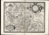
Tartariae Sive Magni Chami Regni typus.
One of the first maps to show the Pacific Northwest.
- Digital Map Information
- Suitable for large format printing
- Full resolution TIFF file
- ICC color profile embedded
- Delivered instantly via download link
One of the first maps to show the Pacific Northwest.
This is Abraham Ortelius' seminal 1570 map of Tartary, one of the first maps to focus on the North Pacific coasts of America and Asia, in a sharp, early edition of 1573. While the map is intended to the Asian empire of the Great Khan, it is also notable for what it presents of America. The map includes what is now the west coast of the United States, northwestern Canada, and Alaska, a part of the world almost entirely unknown at that time. It is the earliest obtainable map to name California. It also one of the most definitive early maps to distinctly separate the continents of Asia and America (via the Strait of Anian) well before the explorers of the 18th century proved that separation to be fact.A Closer Look
The map is a partial conic projection with coverage extending from the Black Sea to the Gulf of California and from the Arctic to southern China, then considered by Europeans to represent the extent of the Tartar Kingdom. In fact, much of the content north of China is mythical or loosely derived from the journals of Marco Polo, the legends of Prester John, and Biblical sources.A Groundbreaking Map
This is one of the earliest maps to attempt a modern mapping of northeast Asia. Prior maps relied on the second-century conjectures of Ptolemy, whose concrete data seldom reached beyond Eastern Europe. The present map is also informed by Marco Polo's 13th-century voyages, but Ortelius does much to reconcile the medieval knowledge of Asia with 16th-century revelations of the Western Hemisphere. The Pacific Ocean is optimistically narrow, particularly at the Strait of Anian, encouraging the notion of a close connection between the Americas and the Orient.Treasure Cities in the Americas
Near America's peninsular California, six of the legendary Seven Cities of Gold are noted: Chicuich, Axa, Tiguas, Totonteas, Chicana, and Coana. The legend of the Seven Cities emerged in Europe long before Columbus, during the Moorish invasion of Spain. It was said that when the Moors invaded Porto, Portugal, in the early 8th century, the city's seven bishops took their substantial wealth and fled to sea, purportedly founding cities on islands to the west. As European explorers pressed onwards without discovering any such cities of gold, their imagined locations were relocated ever westward.Richly Decorative and Evocative
The map is superbly engraved, with an elaborate strapwork-and-floral cartouche. The Pacific Ocean features a flying fish and a sailing ship plying the Strait separating Asia and America (something no European would do for centuries). In the upper right, the Grand Duke of Muscovy sits in a splendid tent and, in Central Asia, another tent houses the Great Khan.A Text-Rich Map
The Asian portion of the map is heavily annotated, revealing that much of Ortelius' information for these remote regions came from a broad range of sources both ancient and modern. Some are puzzling, such as the report of an apocryphal and ill-starred mission of the King of the Tatars to Charles the Fifth. Other textss derive from Biblical interpretation, such as speculations of lost tribes of Israel (specifically the Naphtalites, and the tribe of Dan). For the Arctic Ocean, which he terms the Scythian Ocean, Ortelius relies on both the first-century historian Pliny and Marco Polo. He identifies Turkestan as a region which allied with Persia against the 7th century onslaught of the young Islamic Caliphate. And while Ortelius is more famed for his Prester John map of Africa, here he identifies the land of Argon in extreme northeastern Asia as the location of another Christian Kingdom 'subject to Rome through Prester John of Africa.'Marco Polo's Japan
Japan appears here roughly equidistant to both Asia and America, including a descriptive note derived from Marco Polo reporting that the island had withstood the assaults of the Great Khan. Japan appeared on five different maps in Ortelius' atlas, and was portrayed differently each time: it was among the most remote and puzzling parts of the world for the 16th century European, and over the course of the Theatrum's print run one can observe the development of Ortelius' understanding of Japan run from relative ignorance to remarkable clarity, as reports from Spanish and Portuguese travelers filtered back.Publication History and Census
This map was first issued in 1570 to accompany Ortelius' atlas, Theatrum Orbis Terrarum, and was one of the first fifty-three maps included in the work. This map appears in four states, of which this is the second. The typography of the text on the verso identifies this specific example as belonging to the 1573 Latin edition of the atlas, variant b. Ortelius' masterpiece atlas was successful, and thus is well represented in institutional collections.Cartographer
Abraham Ortelius (April 14, 1527 - June 28, 1598) also known as Ortels, was a cartographer, geographer, and cosmographer of Brabant, active in Antwerp. He was the creator of the first modern atlas, Theatrum Orbis Terrarum and is a seminal figure in the history of cartography. Along with Gerard Mercator and Gemma Frisius, he was a founder of the Netherlandish school of cartography. His connections with Spain - culminating in his 1575 appointment as Royal Cartographer to King Phillip II of Spain - gave him unmatched access to Spanish geographical knowledge during a crucial period of the Age of Discovery. Ortelius was born in 1527 in Antwerp. In 1547 he entered the Antwerp Guild of Saint Luke as an illuminator of maps. He began trading in books, prints, and maps, traveling regularly to the Frankfurt book and print fair, where in 1554 he met Mercator. He accompanied Mercator on journeys throughout France in 1560 and it was at this time, under Mercator's influence, that he appears to have chosen his career as a scientific geographer. His first published geographic work appeared in 1564, an eight-sheet cordiform world map. A handful of other maps preceded the 1570 publication of the first edition of the Theatrum Orbis Terrarum, which would prove to be his life work. Appearing with but 53 maps in its first edition, Ortelius' work expanded with new maps added regularly. By 1592, it had 134 maps. Many of Ortelius' maps remained the standard for nearly a century. He traveled extensively, but his genius was as a compiler, locating the best informed maps on which to base his own. His contacts throughout Europe and extending even (via the Portuguese) to the Far East were formidable. Moreover, many of his maps were based on his own scholarship, particularly his historical works. His theories of geography were particularly ahead of his time with respect to the notion of continental drift, the possibility of which he mused on as early as 1596, and which would be proven correct centuries later. In a sense his greatest achievement was his successful navigation of the religious and political violence endemic to his city throughout his adult life: The Dutch Revolt, or Eighty Years' War (1568 - 1648), fully embroiled Antwerp. Although outwardly and officially recognized as Catholic (Arias Montanus vouched for Ortelius' Catholic orthodoxy prior to his appointment as Royal Geographer), Ortelius was able to separate himself from the religious furor which characterized the war in the low countries. Ortelius showed a glimpse of himself in a letter to a friend, regarding humanist Justus Lipsius: 'I do not know whether he is an adherent of the Pope or a Calvinist, but if he has ears to hear, he will neither be one nor the other, for sins are committed on both sides'. Ortelius' own explorations of Biblical history in his maps, and the Christogram contained in his own motto, suggest him to be a religious man, but his abjuration of political religious authorities mark him as an individualist. His tombstone at St Michael's Præmonstratensian Abbey in Antwerp bears the inscription, Quietis cultor sine lite, uxore, prole. ('served quietly, without accusation, wife, and offspring.') Further Details...
Source
Ortelius, A., Theatrum Orbis Terrarum, (Antwerp: Plantin) 1573.
Abraham Ortelius' magnum opus, Theatrum Orbis Terrarum, was the world's first regularly produced atlas, which 'set the standards for later atlases ... It was the first undertaking of its kind to reduce the best available maps to an uniform format.' (Koeman) A modestly-sized work of fifty-three maps in its first edition of May 1570, it was an immediate success: there were three further editions that year, and the work remained in print for a total of 32 editions, the last of which was 1641, well after its author's 1598 death. Ortelius added to his atlas constantly, and by 1595 the Theatrum contained 147 maps. Ortelius is renowned generally as an editor, and indeed much of the Theatrum is compiled from a variety of sources: in such cases, Ortelius was scrupulous in naming his sources. But Ortelius was also a mapmaker in his own right: many of his maps are a distillation of various sources into his own work, and there were many maps - particularly in his atlas of Biblical and ancient history Parergon - which were entirely Ortelius' work. In his role as an editor, Ortelius followed in the footsteps of Munster, whose Cosmographia was, until Ortelius, the best window on the world for the curious European reader. In terms of the artistry of his maps, Ortelius oversaw the first great flourishing of copperplate engraving in the service of cartography to occur in Northern Europe. Ortelius' work provided the model for the atlases of Mercator, Hondius, Blaeu and all their progeny in the 17th century - many of whom were to produce faithful editions of Ortelius' maps in their own productions.
Condition
Very good. Centerfold reinforced at top and bottom. Else excellent with a remarkably sharp strike.
References
Rumsey 10000.103(1570). van den Broecke, M. Ortelius Atlas Maps, Ort 163 (State 2). Burden, P., The Mapping of North America, #41. Van der Krogt, P. C. J., Koeman's Atlantes Neerlandici, (3 Vols) 8050:31. Wheat, C. I., Mapping of the Transmississippi West, 1540 - 1861, #16. Wagner, H. R., The Cartography of the Northwest Coast of America To the Year 1800, #81. Cortazzi, H., Isles of Gold: Antique Maps of Japan, plate 16. Walter, L., Japan: A Cartographic Vision: European Printed Maps from the Early 16th to the 19th Century, #11E.